Brian Peters: Rain today and colder Wednesday in Alabama

A cold front will be moving slowly but steadily across the Southeast US today and Wednesday. This will produce a rainy day for today and usher in some colder weather for Wednesday. Fortunately for us, colder does not mean extreme cold as the upper flow does not become strongly northwesterly. Temperatures will be held down today as compared with yesterday but we should still see most places reach the upper 50s. The rain will take its time moving across the state but should be exiting Central Alabama late tonight. Wednesday will see a good deal of clouds as the somewhat colder air reaches us with highs in the upper 40s.
 The trough finally comes by Thursday which will see the coolest morning with lows around 30 degrees. Highs Thursday should bounce back a little with highs in the lower and middle 50s.
As the surface high moves by us on Friday, the upper flow will become nearly zonal across the southern tier of the US. This signals a nice warmup as we head into the weekend. By Saturday the morning lows will still be in the 30s but most spots should stay at or slightly above freezing.
With a good supply of sunshine, the upper flow becoming southwesterly, and the surface flow coming around to the south, those afternoon highs should surge upward with highs in the lower 60s. Those values will be about 8 to 10 degrees above the late January 30-year averages.
We stay dry until Tuesday as we benefit from the southerly surface flow as well as the southwesterly flow aloft. That should keep highs in the 60s and lows in the middle 40s to lower 50s. The next good chance for rain will come on Tuesday with the approach of a cold front.
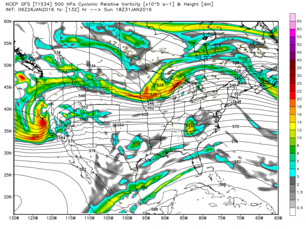
The main storm system located in the Central Plains is expected to be a very strong one. This could mean a round of severe weather for Tuesday from the Lower Mississippi River Valley into the Ohio River Valley as well as a significant round of winter weather behind the low from Colorado to Minnesota. We’re verging on voodoo country here, so no specifics just yet, but this will definitely bear close watching.
That strong upper low will come by around the 3rd of February as we trend colder once again but not extremely cold. Another trough comes across the Lower Mississippi River Valley around the 5th, but that trough is followed by a nearly zonal flow for the last several days of the forecast period. So for now there does not appear to be any signs of any extreme cold for us to deal with.
For more information, visit Alabamawx.com.


