James Spann: Alabama’s winter storm watch expands southward
James Spann: Winter weather problems possible Friday for much of Alabama from Alabama NewsCenter on Vimeo.
CALM TODAY: While all of the attention is focused on wintry precipitation possibilities tomorrow, we need to mention that today will a cool, calm day for the state. We are in the 27- to 32-degree range early this morning, and the high this afternoon should be in the low 50s with a mix of sun and clouds.
WINTER STORM WATCH EXPANDED: Confidence is growing in the scenario tomorrow as models are in better agreement. The National Weather Service has expanded the Winter Storm Watch southward to include counties as far south as Sumter, Marengo, Dallas, Autauga, Elmore, Tallapoosa and Chambers.

The watch will be in effect from 6 a.m. tomorrow through 9 a.m. Saturday.
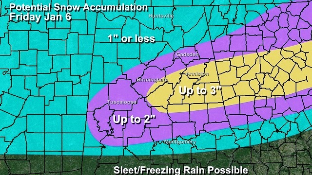
Light snow will likely move into the northern third of Alabama early tomorrow morning; to the south a mix of light sleet and light snow is possible across the central counties, with rain over South Alabama. As better dynamics come into play, and cold Arctic air drops southward, precipitation will increase late tomorrow afternoon and tomorrow night, with snow and sleet possible down to U.S. 80. Then, late tomorrow night and early Saturday morning, there is a chance of some sleet, freezing rain or even a few snowflakes deep into South Alabama. There’s some chance all 67 Alabama counties could see a little freezing or frozen precipitation by Saturday morning when it all winds down.
The heavier snow will most likely come over East-Central Alabama, but amounts to 2 inches are possible across all of the Winter Storm Watch area. It is important to understand there will be some places in the Winter Storm Watch that see only a few snowflakes and no accumulation.

NOTE: It is likely that a Winter Weather Advisory will be needed for parts of Alabama tomorrow as the event begins to unfold. That is an upgrade from a Winter Storm Watch.
Here is a look at the impacts you can expect tomorrow.
POWER: We do not expect power outages tomorrow, since for most places snow accumulation will be relatively light and winds won’t be over 25 mph. In Alabama, it usually takes lots of freezing rain (an ice storm) or heavy, wet snow for major outages in winter.
ROADS: Light snow could begin early tomorrow over the northern third of the state, with icy spots developing on bridges and overpasses. Soil temperatures are relatively warm, so many road surfaces will be wet initially, but keep in mind many places across North Alabama will stay below freezing all day tomorrow, meaning potential for some icy travel where snow falls.
But the most widespread travel issues will come late tomorrow afternoon, through tomorrow night and into Saturday morning as precipitation rates increase and temperatures fall into the 20s. Roads could very well become icy and dangerous over the northern half of Alabama, where the heavier precipitation comes down. The main travel issues will be in the Winter Storm Watch area, but we can’t rule out a few spotty issues to the south as well.
Keep in mind icy travel is likely to the north and east of Alabama, with some of the heaviest snow likely over parts of North and Central Georgia up into the Carolinas. Atlanta could be a big mess Saturday morning.

BIRMINGHAM-SHUTTLESWORTH AIRPORT: Snow could mean potential for flight delays or reduced operation, mainly tomorrow afternoon and tomorrow night.
STAY UP TO DATE: If you are using old weather information (more than six hours old), that is bad information. More changes in the forecast are very possible during the day today.
FRIGID WEEKEND: The wintry precipitation will end early Saturday morning, and the weekend will be very cold and dry. We won’t get out of the 30s Saturday, and early morning temperatures will drop into the 15- to 20-degree range both Sunday and Monday morning.
NEXT WEEK: Expect a warm-up, with rain returning by Tuesday night and Wednesday.
WEATHER BRAINS: You can listen to our weekly 90-minute netcast anytime on the web, or on iTunes. This is the show all about weather featuring many familiar voices, including meteorologists at ABC 33/40.
CONNECT: You can find me on all of the major social networks:
Facebook
Twitter
Google Plus
Instagram
For more weather news and information, visit AlabamaWX.