Bill Murray: Round One of severe weather moving through Alabama; Round Two tonight

IT’S HERE: Our well-advertised morning rain and thunderstorm event is in progress across Central Alabama. The complex arrived in West Alabama before sunrise after wreaking havoc across southern Mississippi overnight. A significant tornado struck the Hattiesburg and Petal areas of southeast Mississippi just after 4 a.m. It crossed I-59 about 1 mile south of Forrest General Hospital. William Carey University sustained damage, and a fire station was struck. Injuries were reported. This storm moved into Choctaw County, Alabama, where some wind damage was reported. It weakened, though, as it moved into Marengo County.
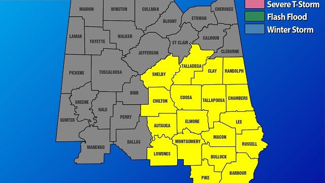
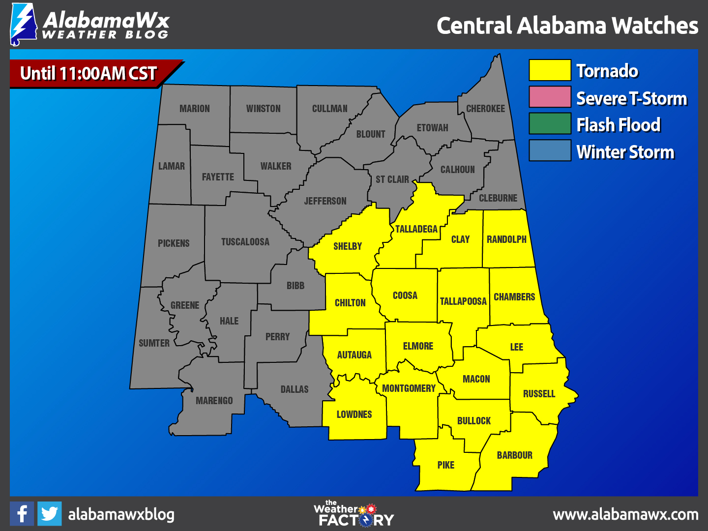
MORNING MESO: This morning’s activity is associated with a well-developed mesoscale convective vortex that will track just south of I-59 through the morning. It was passing south of Tuscaloosa as I wrote this. The large area of rain and embedded thunder will continue along and north of the track, but no severe weather is expected with this activity. To the south,there is still the chance of damaging winds and an isolated tornado or two. A tornado watch remains in effect until 11 a.m. for counties south of the row of counties that includes Hale, Bibb, Shelby, Talladega, Clay and Randolph.
BACK EDGE: The rain should end in Tuscaloosa by 10 a.m. and Birmingham before 11 a.m. The heaviest rain will be out of the Birmingham area by 9:30 a.m. or so. One- to 2-inch amounts should be pretty common across the area.
CLEARING COMES LATER: Within a couple of hours after the rain departs, you will see clearing skies. This increasing sunshine will allow the mercury to top out around 70 degrees.
TONIGHT/TOMORROW MORNING: The threat for more severe weather will increase again late tonight through Sunday morning. Another shortwave will move out of the low-pressure center in the Southern Plains. The latest guidance is showing more thunderstorms developing and moving into the northwestern parts of Central Alabama sometime after 11 tonight. Stronger low-level shear will lead to the potential for isolated tornadoes across the area, but the higher chances will be for those in the southeastern portions of the area. There will be a higher hail threat for the storms that will move through the northwestern parts of the area. The threat of golf-ball-sized hail or larger, damaging winds and a few isolated tornadoes will exist for these northwestern locations. For the locations between these two higher-risk areas, threats will be lower. There will be enough low-level shear and instability for a limited risk for small hail and damaging winds, and a brief tornado is not out of the question. Timing for strong to severe storms will be from 11 tonight until 6 tomorrow morning.
SUNDAY AFTERNOON AND EVENING: Looking at the latest run of the North American Mesoscale 3km model, there will be several rounds of rain moving through the area for the remainder of the afternoon and evening. There will be a few breaks in the rain coverage, so it will not be a complete wash-out. Afternoon highs will be in the lower to mid 60s for the early afternoon and will fall into the mid 40s for the overnight low. No severe weather will be expected after 6 a.m. Rain totals through the day will mostly be around 1 inch or less throughout the area, with a few locations in the northeastern corner of the state possibly picking up a little more.
BENIGN, AND THEN COOLER: Showers should move out early Monday morning, with clearing skies and a brisk northwest wind. Highs on Monday should be limited to the lower 50s, but the real airmass change won’t come until later in the week. Expect 30s Tuesday morning and 40s Wednesday morning, with highs both days in the 60s. As a trough moves eastward across the northern United States, it will allow colder air to infiltrate the Southeast by Wednesday night and Thursday. There could be a few showers with this front, and temperatures will drop behind it. Highs will be in the 50s Thursday, but will struggle to reach 50 degrees on Friday. Highs in the 40s will be commonplace on Saturday. Lows will go back below freezing for the end of the week.
HEADED TO THE BEACH: Showers and thunderstorms are likely throughout the day today and tomorrow, but partly sunny skies return for the first part of the week. Highs will be in the 70s throughout the weekend, then will briefly fall back into the 60s Monday and Tuesday. Click here to see the Beach Forecast Center page.
HEAR TIM MARSHALL: Are you a member of the Central Alabama Chapter of the National Weather Association? Come hear a world-class weather speaker Tuesday evening at Vulcan, when Tim Marshall will share his countless tornado stories. Ten dollars will get you in, unless you’re a member, which is $25 for the year. Join on the spot or online. Meet and greet at 6; meeting starts at 6:30.
WEATHER BRAINS: The weekly netcast that’s all about the weather had a great time visiting with Jesse Haro, the Meteorologist in Charge at the National Weather Service in San Francisco. He shared lots of information about California weather and meteorology and social media. Check out the show on iTunes or at WeatherBrains.com. Tim Marshall will be next week’s guest.
For more weather news and information from James Spann, Bill Murray and other members of the James Spann team, visit AlabamaWX.


