James Spann: Rain moves into Alabama later today; subfreezing mornings ahead
James Spann: Much colder air hits Alabama for the next three days from Alabama NewsCenter on Vimeo.
TURNING WET: Rain will push into Alabama today ahead of a strong disturbance that is one ingredient that will spin up the “Blizzard of 2017” for the Northeast U.S. tomorrow. Most of the rain across our state will come from noon to midnight, and amounts around one-half inch are likely. The high this afternoon will be in the 48- to 52-degree range for most communities.
TOMORROW: The day will be breezy and cold, and we could see a few sprinkles tomorrow morning. There’s even a chance of a few snow flurries over the northern third of the state as the cold air rushes in. Clouds linger much of the day, and the high will be between 47 and 50 degrees.
SUBFREEZING MORNINGS: We project lows in the 20s both Wednesday and Thursday mornings; colder pockets across North Alabama could see upper teens Thursday morning, with a clear sky and light wind. Wednesday and Thursday will be sunny; the high Wednesday will stay between 47 and 50 degrees, with low 50s Thursday. Keep in mind our average highs are in the mid to upper 60s in mid-March; temperatures this week are way below average.
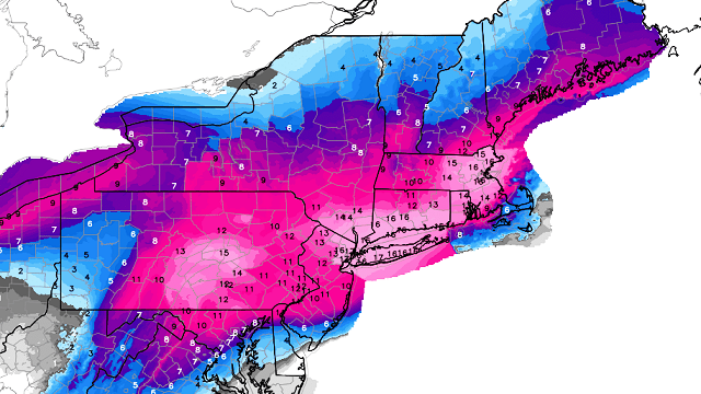
NORTHEAST U.S. BLIZZARD: A crippling blizzard will impact major cities like Philadelphia, New York City and Boston tomorrow and tomorrow night, with snow amounts of 1-2 feet. Travel in and out of these places will be shut down for a couple of days.

FRIDAY AND THE WEEKEND: Forecast confidence is not especially high due to model inconsistency; for now we will mention some scattered light rain Friday, Saturday and Sunday with a pronounced warming trend. We rise into the low 60s Friday, upper 60s Saturday and mid 70s Sunday. We will be able to be more specific on the timing of the rain later this week, but for now it looks like it won’t be anything especially heavy.
NEXT WEEK: It will feel like spring again as highs go up into the 70s. Seems like there will be a decent rain event toward the end of the week that might feature some strong storms.

ON THIS DATE IN 1993: The great “Blizzard of 93” was winding down. It was one of those very rare times when all 67 counties in Alabama had a snow cover. Here is a selection:
- 20 inches at Walnut Grove.
- 17 inches at Valley Head.
- 16 inches in Oneonta and Bessemer.
- 13 inches at Anniston, Talladega, Pinson and Birmingham.
- 12 inches at Thomasville, Childersburg and Scottsboro.
- 11 inches at Sylacauga.
- 10 inches at Cullman, Clanton and Heflin.
- 9 inches in Thorsby.
- 8 inches in Ashland, Centreville, Moulton and Guntersville.
- 7 inches in Alexander City, Huntsville and Whatley.
- 6 inches in Camden, Evergreen, Jasper, Livingston, Andalusia, Haleyville and Highland Home.
- 5 inches in Auburn, Winfield, Muscle Shoals and Chatom.
- 4 inches in Montgomery, Union Springs, Vernon, Tuscaloosa, Demopolis, Frisco City, Greenville and Troy.
- 3 inches at Brewton, Hamilton, Bay Minette and the Mobile Airport.
- 2 inches at Atmore and Robertsdale.
- A trace at Fairhope and Coden.
Remember, this does not count drifts. Those drifts were humongous in some areas, especially by Alabama standards. The drifts were 5 to 6 feet deep in parts of the Birmingham metro area.
WEATHER BRAINS: You can listen to our weekly 90-minute netcast anytime on the web, or on iTunes. This is the show all about weather featuring many familiar voices, including meteorologists at ABC 33/40.
CONNECT: You can find me on all of the major social networks:
Facebook
Twitter
Google Plus
Instagram
Pinterest
Snapchat: spannwx
For more weather news and information, visit AlabamaWX.