James Spann: Alabama trending drier, hotter for Friday, Saturday
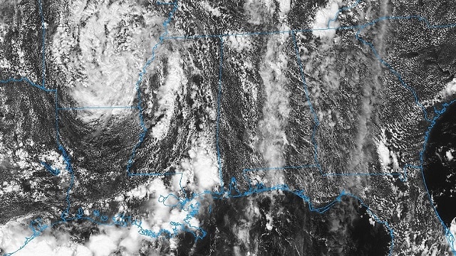
RADAR CHECK: In the moist air over Alabama we have a number of scattered showers and thunderstorms this afternoon. They are moving northeast and are producing heavy rain, gusty winds and lots of lightning. Showers will end after the sun goes down.
FRIDAY AND THE WEEKEND: The upper ridge will begin to strengthen across Alabama, and as the air becomes more stable, heat levels will rise and afternoon showers will become fewer in number. Look for a partly sunny sky both days with a high around 90 degrees. The chance of any one spot getting wet is around 20 percent during the afternoon and evening hours.
Afternoon showers and thunderstorms will become more numerous over the northern third of the state on Sunday as a surface front drifts down into Tennessee. Otherwise, expect a mix of sun and clouds Sunday with a high in the upper 80s.
FOOTBALL WEATHER: For the high school games Friday night, there will be just a small risk of a shower during the first half; otherwise it should be mostly fair and very warm, with temperatures falling though the 80s during the games.
Alabama hosts Arkansas State Saturday afternoon in Tuscaloosa at Bryant-Denny Stadium (2:30 p.m. kickoff); the sky will be partly to mostly sunny with just a small risk of a shower during the game. It will be a hot and humid day. The kickoff temperature will be close to 90 degrees, falling back into the 80s by the fourth quarter.
Auburn will host Alabama State Saturday evening at Jordan-Hare Stadium (6:30 p.m. kickoff). The sky will be mostly fair with only a slight risk of a shower during the first half. Temperatures will fall from near 86 at kickoff into the upper 70s by the final whistle.
UAB travels to Conway, South Carolina, to take on Coastal Carolina Saturday evening (6 p.m. kickoff). A shower or storm is possible during the first half of the game; otherwise it will be warm and humid, with temperatures falling through the 80s during the game.
NEXT WEEK: The weather looks rather unsettled next week with moist, unstable air over the state and a stalled surface front just to the north. The sky will be occasionally cloudy with scattered to numerous showers and thunderstorms each day; highs will be mostly in the mid 80s.
FLORENCE: Hurricane Florence, in the Atlantic far from land, has weakened today because of shear and dry air; top winds are now 105 mph. It is expected to grow stronger again late this weekend, becoming a major hurricane again south of Bermuda early next week. The mean of the European global model ensemble shows the hurricane recurving before making landfall on the U.S. East Coast late next week, but it is still too early to call. Interests along the Atlantic coast of the U.S. need to keep a close eye on Florence in coming days and watch for updates.
HELENE/ISAAC?: Two well organized waves are in the far eastern Atlantic; the lead wave is expected to become Tropical Storm Helene over the next few days. It could be close to the northern Leeward Islands in 5-6 days, but it’s still too early to know if this one will be a problem for North America. The wave just coming off the coast of Africa is expected to become Tropical Storm Isaac in a few days.
BEACH FORECAST: Click here to see the AlabamaWx Beach Forecast Center page.
WEATHER BRAINS: You can listen to our weekly 90-minute netcast any time on the web, or on iTunes. This is the show all about weather featuring many familiar voices, including meteorologists at ABC 33/40.
CONNECT: You can find me on all of the major social networks:
Facebook
Twitter
Instagram
Pinterest
Snapchat: spannwx
For more weather news and information from James Spann and his team, visit AlabamaWx.com.
