James Spann: Unsettled weather for Alabama through tomorrow, then much colder
James Spann has the Alabama forecast for the rest of the work week from Alabama NewsCenter on Vimeo.
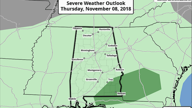
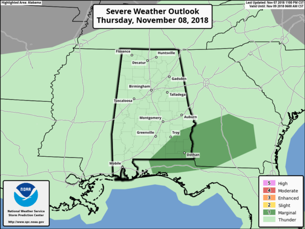
RADAR CHECK: A band of rain and storms is pushing through Alabama early this morning; some of you will hear some thunder, but the storms are not severe. We will continue to mention periods of rain today and tonight; otherwise, the sky will be cloudy with a high close to 60 degrees. There is a marginal risk (level 1 out of 5) of severe storms over southeast Alabama today below a stalled surface front.
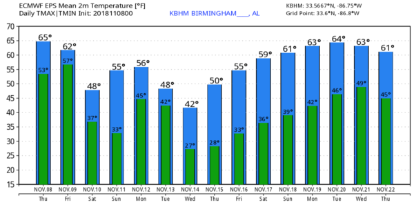
TOMORROW: Rain is likely tomorrow morning as a cold front pushes through the state; the rain tapers off by afternoon, and temperatures will go the wrong way. We start the day in the 50s, but fall into the 40s during the afternoon with a brisk north wind. The sky will clear tomorrow night, and the rain should be gone in time for the high school football games.
THE ALABAMA WEEKEND: Many north and central Alabama communities will experience their first freeze of the season early Saturday; we project a low between 28 and 34 degrees with a clear sky. During the day Saturday, the sky will be sunny with a high around 50 degrees. Sunday morning will be cold again with widespread frost likely; then clouds increase during the day with a chance of rain by the evening. The high Sunday afternoon will be in the upper 50s.
FOOTBALL WEATHER: For the high school games Friday night, we expect a clearing sky with temperatures falling through the 40s.
Saturday, Alabama hosts Mississippi State at Bryant-Denny Stadium (2:30 p.m. kickoff). The sky will be sunny with a kickoff temperature near 53 degrees, falling into the 40s by the fourth quarter.
Auburn is at Georgia Saturday (6 p.m. kickoff). The sky will be clear with temperatures falling from near 50 at kickoff into the low 40s by the final whistle.
UAB will host Southern Miss at Legion Field Saturday evening (6:30 p.m. kickoff). The sky will be clear with temperatures falling through the 40s.
NEXT WEEK: A cold rain is likely Monday as a wave of low pressure moves across the northern Gulf of Mexico; we will struggle to get out of the 40s. Tuesday promises to be a cold, raw, windy day; rain ends during the morning, but the sky will stay cloudy with a brisk north wind of 12 to 25 mph. Some places across the Tennessee Valley of far north Alabama won’t reach 40; the high for the central counties of the state will be only in the mid 40s, and the wind will make it feel colder.
The sky will clear Tuesday night, and we project a low early Wednesday in the mid 20s, right at record levels for Nov. 14. Birmingham’s record low for the date is 24, set in 1986. The rest of the week will be dry with a slow warming trend.
TROPICS: Tropical storm formation is not expected across the Atlantic basin through the weekend.
BEACH FORECAST: Click here to see the AlabamaWx Beach Forecast Center page.
WEATHER BRAINS: You can listen to our weekly 90-minute show any time on your favorite podcast app. This is the show all about weather featuring many familiar voices, including meteorologists at ABC 33/40.
CONNECT: You can find me on all of the major social networks:
Facebook
Twitter
Instagram
Pinterest
Snapchat: spannwx
For more news and information from James Spann and his team, visit AlabamaWx.


