James Spann: Alabama trends colder in days ahead
James Spann has the midweek forecast for Alabama from Alabama NewsCenter on Vimeo.
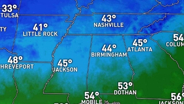
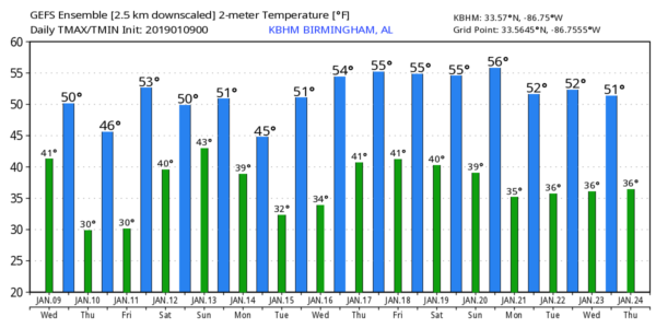
WINDY, COOLER TODAY: Look for sunshine in full supply across Alabama today, but the day will be cooler with a high in the 50s, and a brisk northwest wind of 12-22 mph will make it feel colder. The winds will calm down tonight, allowing temperatures to drop into the 20s across north and central Alabama early Thursday morning. Freezing temperatures are likely deep into south Alabama.
Thursday and Friday will be sunny with cold mornings; the high will be in the 40s for the northern half of the state Thursday, with low 50s Friday. Clouds will move in Friday night.
THE ALABAMA WEEKEND: Saturday will be a cloudy, cool day with periods of rain as a surface wave of low pressure moves across the state. The latest data from global models suggest the best chance of meaningful rain will come from about noon until midnight; rain amounts will be around one-half inch. The air will be stable, so there will be no worries with severe storms, and most will hear no thunder.
Sunday will be cloudy and cool, and there will be some risk of a little lingering light rain or drizzle during the morning. The high Sunday will be in the 48- to 54-degree range for most communities across north and central Alabama.
NEXT WEEK: The weather looks dry with seasonal temperatures Monday through Wednesday; highs will be mostly in the 50s and lows in the 30s. Rain will return late in the week; the latest data suggest rain is most likely Thursday night into Friday. There’s no sign of any winter weather mischief for Alabama anytime soon (snow, sleet, freezing rain, etc.).
ON THIS DATE IN 2006: With cold air sweeping in from the Himalayas, New Delhi reported frost for the first time in 70 years with a low temperature of 32.3 degrees. The cold prompted officials to order all schools to close for three days.
ON THIS DATE IN 2011: Snow and freezing rain developed across Alabama during the afternoon and evening, and by daybreak the following day (Jan. 10, 2011), areas north of Interstate 20 were reporting anywhere from 1 to 14 inches of snow, with the heaviest totals near the Alabama-Tennessee state line. Ice reports were as high as one-half inch in multiple counties south of Interstate 20. Businesses and schools had declared they would be closed on Monday, Jan. 10, and for good reason. Road conditions around central Alabama caused many counties to declare that roads would be closed. Unfortunately, this winter weather event caused the loss of at least two lives on area roadways because of slick conditions.
BEACH FORECAST: Click here to see the AlabamaWx Beach Forecast Center page.
WEATHER BRAINS: You can listen to our weekly 90-minute show any time on your favorite podcast app. This is the show all about weather featuring many familiar voices, including meteorologists at ABC 33/40.
CONNECT: You can find me on all of the major social networks:
Facebook
Twitter
Instagram
Pinterest
Snapchat: spannwx
For more weather news and information from James Spann and his team, visit AlabamaWx.