James Spann: One more dry day for Alabama; showers return Wednesday
VERY PLEASANT LATE WINTER DAY: The sky is mostly sunny across Alabama today, with just a few high-altitude cirrus clouds overhead. Temperatures are mostly in the 60s, although some places over the northern quarter of the state are in the upper 50s. Tonight will be mostly fair and not as cold as last night; we project a low between 36 and 42 degrees for most places. Colder valleys could see another freeze.
Tuesday will be dry for most of the state, although a few showers are possible near the Gulf Coast, maybe even a strong storm. The Storm Prediction Center has southern parts of Mobile and Baldwin counties in a marginal risk (level 1 of 5) for severe storms as the air becomes unstable there. With a partly sunny sky we expect a high in the mid to upper 60s.
WEDNESDAY THROUGH FRIDAY: Moisture returns Wednesday, and we will mention a chance of showers statewide — maybe even a thunderstorm in spots. But it won’t rain all day, and the sun could break out at times. The high will be close to 70 degrees as the warming trend continues.
Expect occasional showers and possibly a thunderstorm Thursday and Friday as a moist, unstable air mass stays in place. For now we don’t expect any severe storms, and rain amounts should be around 2 inches. No additional flash flooding issues are forecast, but, of course, river levels will remain high.
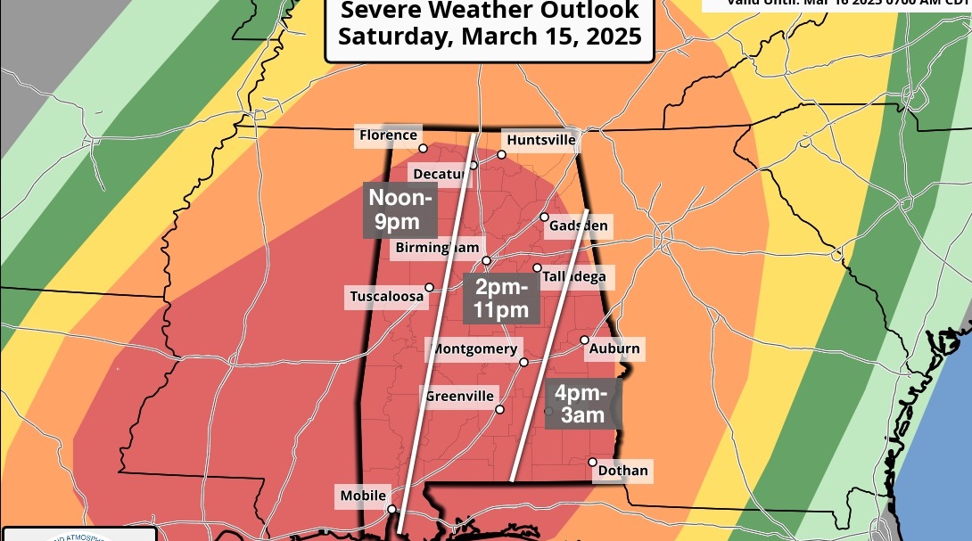
THE ALABAMA WEEKEND: The weekend forecast is fairly challenging as a cold front pushes into the state. The front will become stationary somewhere across the region, and where this happens will pretty much determine our weather. We will maintain a chance of rain Saturday morning; otherwise the day will be cloudy and colder with temperatures falling through the 50s over the northern half of the state. A wave of low pressure forms on the stalled front to the west, and Sunday looks cold and wet, with periods of rain and a high only in the 40s.
There is evidence that the air could be cold enough for some wintry precipitation over far north Alabama Sunday night or Monday, but there is absolutely no skill in a specific forecast this far out. The pattern looks cold and unsettled Sunday and Monday; we will have a much higher-confidence forecast later this week.
NEXT WEEK: Temperatures should stay below average for much of the week, and drier air should return by Tuesday and Wednesday.
TORNADO SURVEYS: National Weather Service Birmingham identified three tornadoes in Alabama from Saturday’s thunderstorms: an EF-1 near Kingville in Lamar County (between Vernon and Kennedy); another EF-1 in Coosa County southeast of Rockford, and an EF-0 near the Fayette/Walker county line. Thankfully there were no injuries. The tornado at Columbus, Mississippi, was rated EF-3 by the NWS Jackson. One person was killed there and 11 injuries were reported.
BEACH FORECAST: Click here to see the AlabamaWx Beach Forecast Center page.
WEATHER BRAINS: You can listen to our weekly 90-minute show any time on your favorite podcast app. This is the show all about weather featuring many familiar voices, including the meteorologists at ABC 33/40.
CONNECT: You can find me on the major social networks:
Facebook
Twitter
Instagram
Pinterest
Snapchat: spannwx
For more weather news and information from James Spann and his team, visit AlabamaWx.