James Spann: Dry weather for most of Alabama today
James Spann has the Alabama forecast to start the work week from Alabama NewsCenter on Vimeo.
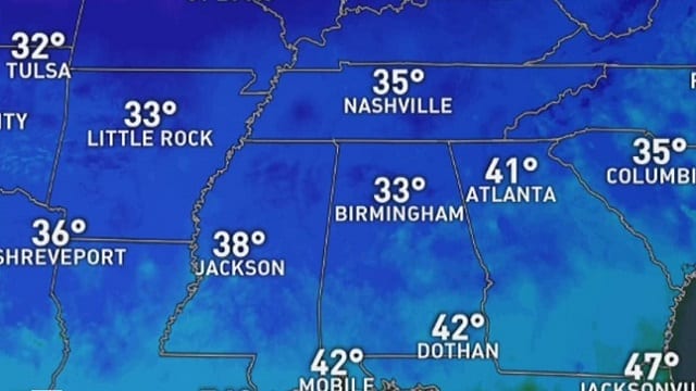
CHILLY START: Temperatures are generally in the 28- to 34-degree range across Alabama early this morning; the air remains dry and we expect ample sunshine today with a high in the low 60s this afternoon. A few showers could appear in the Gulf Coast region late this afternoon and tonight, mainly over Mobile and Baldwin counties.
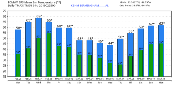
Tonight will be mostly fair for the northern half of the state with a low in the 38- to 42-degree range early Tuesday. Then, during the day, the sky will be partly sunny with a high between 65 and 69 degrees. Showers remain possible near the Gulf Coast during the day. Clouds will increase statewide Tuesday night.
WEDNESDAY THROUGH FRIDAY: The weather will be unsettled over the latter half of the week. A few showers are possible Wednesday, but nothing too heavy or widespread, with a high in the 60s. Showers will be a bit more numerous Thursday and Friday, and thunderstorms could be involved Friday as the air becomes unstable. The degree of instability Friday will certainly support strong storms, but the surface and upper air features you need for severe storms, for now, don’t look overly impressive. That could always change, of course, in coming days.
Rain amounts will be in the 2-inch range Wednesday through Friday night, so for now we don’t expect any flooding issues.
THE ALABAMA WEEKEND: Showers and storms will end very early Saturday morning; we expect a clearing sky and colder temperatures during the day, with a high in the 50s. Some places over north Alabama could drop into the 40s with a brisk north wind. There is great uncertainty concerning Sunday’s forecast; the American global model (the GFS) keeps us dry, while the European model (the ECMWF) brings moisture back quickly with cold rain likely. We will trend the forecast toward the wetter Euro model for now. One way or another Sunday will be chilly, with a high only in the 40s.
NEXT WEEK: There will be some risk of rain early in the week, and temperatures look to be below average for a decent part of the week.
TORNADO SURVEYS: The National Weather Service Birmingham identified two tornadoes in Alabama from Saturday’s thunderstorms — an EF-1 near Kingville in Lamar County (between Vernon and Kennedy), and an EF-0 near the Fayette/Walker county line. Thankfully there were no injuries. The tornado at Columbus, Mississippi, was rated EF-3 by the NWS Jackson. One person was killed there, and 11 injuries were reported.
RIVER FLOODING: Flooding continues along many major rivers in Alabama. Cherokee County is in a state of emergency because of the flooding. A curfew is in effect for the Town of Cedar Bluff from 9 p.m. until 6 a.m. daily until the state of emergency has expired. The curfew is to help deter looting and help prevent driving into unexpected hazards caused by the flooding.
BEACH FORECAST: Click here to see the AlabamaWx Beach Forecast Center page.
WEATHER BRAINS: You can listen to our weekly 90-minute show any time on your favorite podcast app. This is the show all about weather featuring many familiar voices, including the meteorologists at ABC 33/40.
CONNECT: You can find me on the major social networks:
Facebook
Twitter
Instagram
Pinterest
Snapchat: spannwx
For more weather news and information from James Spann and his team, visit AlabamaWx.


