Scott Martin: Last day for the blast furnace in Alabama; rain, cooler weather on the way
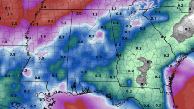
RAINFALL TOTALS FOR THE NEXT SEVEN DAYS: The quantitative precipitation forecast map shows a mix of colors over Alabama, which means we finally get some rainfall. Much of central Alabama is forecast to get more than one-half inch to nearly 1 inch of rain over the next seven days, while some in the northern parts of the state could get up to 2 inches. While it’s not drought-busting rainfall, it may keep conditions from worsening.
BETTER RAIN CHANCES TODAY: We may continue our streak of record-breaking high temperatures across parts of the state, but a backdoor wedge will force more moisture-rich air into eastern Alabama. This will bring a decent chance of scattered afternoon and early evening showers and thunderstorms to the state, with the higher chances in the eastern half. Afternoon highs will reach the mid-90s, with a few spots hitting the upper 90s. Rain chances will be in the 20%-50% range from west to east. For tonight, the better rain chances shift to northwestern Alabama. Those chances will range from 20% to 50% from southeast to northwest. Lows will be in the mid to upper 60s for most.
BYE-BYE 90s, HELLO COOLER WEATHER: Sometimes you would hate for it to rain on a weekend, but after the miserable, dry late summer and early fall, I’m sure most of us would take a few showers. A cold front will be approaching from the northwest, and with an already-moist atmosphere out ahead of it we’ll see higher rain chances, especially for northwestern Alabama. Afternoon highs will be in the mid to upper 80s. Rain chances will be in the 20% to 60% range from southeast to northwest. Those rain chances will rise during the late-night and overnight hours as the front starts to move into the northwest corner of Alabama.
MONDAY/TUESDAY: Our real first shot of fall weather will come Monday as the cold front continues to work through Alabama. We’ll have periods of showers and a few claps of thunder, but no severe weather is expected. Highs will be in the lower 70s to the upper 80s from northwest to southeast. The front will be out of the state on Tuesday, but a few lingering showers are possible over the southeastern portions during the day. Skies will be clearing behind that, with highs reaching the upper 70s to the mid-80s from north to south.
WEDNESDAY/THURSDAY: This latest run has introduced a small chance of a few isolated showers during the heating of the day on Wednesday, especially for the southern half of Alabama. Highs will be back up in the lower to mid-80s. Thursday will be much the same, but the focus of the small chance of isolated showers moves to the western parts of the state as another cold front approaches from the west. Highs will be in the lower to mid-80s.
END OF THE WORK WEEK: The cold front will move through Alabama during the daylight hours but will lose its punch as it moves eastward. Rain chances will be highest during the morning on the western side of the state, but at this point they top out at only 30%. The front looks to lose moisture as it moves through, so rain chances will diminish somewhat throughout the day. Highs will be in the upper 70s to the mid-80s.
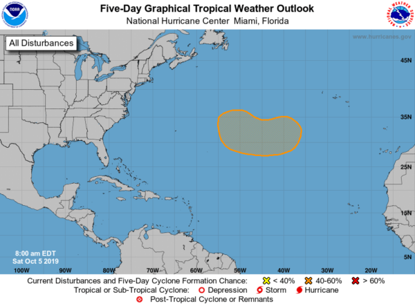
TROPICS: For now, all of the Atlantic Basin is quiet, but in a few days we could see a tropical disturbance develop over the northern Atlantic between the Azores and Bermuda. There is a medium chance of tropical or subtropical development with this disturbance during the middle of next week as it moves west; the National Hurricane Center is giving it a 40% chance of growing into a depression.
BEACH FORECAST CENTER: Get the latest weather and rip current forecasts for the beaches from Fort Morgan to Panama City on our Beach Forecast Center page. There, you can select the forecast of the region you are interested in.
For more weather news and information from James Spann, Scott Martin and other members of the James Spann team, visit AlabamaWx.com.


