James Spann: Alabama stays dry through Friday
James Spann has the midweek forecast for Alabama from Alabama NewsCenter on Vimeo.
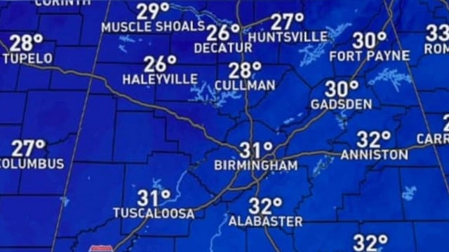
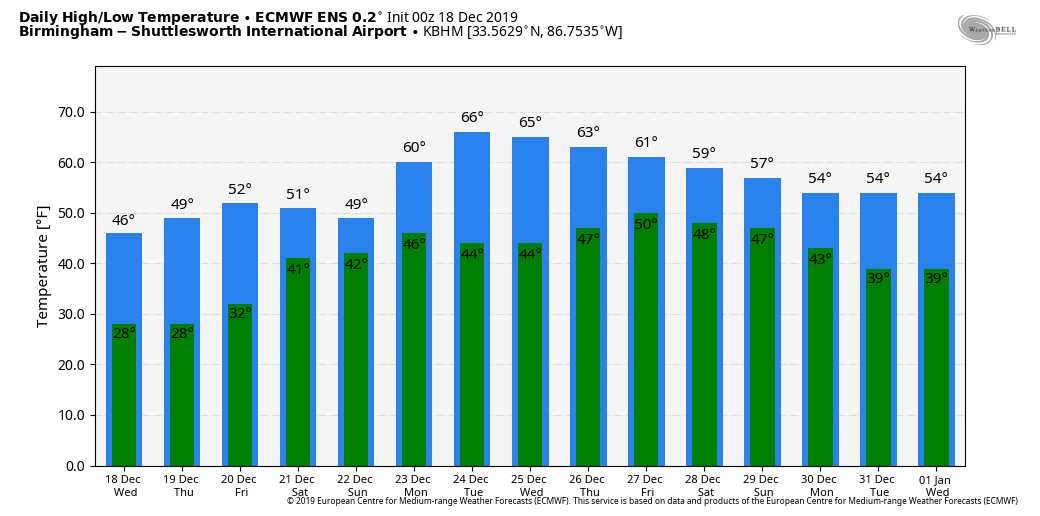
BRIGHTER DAY: Dry air returns to Alabama today. Look for a sunny sky with a high in the 45- to 50-degree range this afternoon, still about 5 to 8 degrees below average for Dec. 18. Tonight will be clear and cold again; most north and central Alabama communities will be in the 20s by daybreak Thursday. The weather remains dry Thursday and Friday; we rise into the low 50s Thursday and then the mid to upper 50s Friday. The sky will be mostly sunny Thursday and partly sunny Friday. Clouds thicken Friday night.
THE ALABAMA WEEKEND: Saturday will be a cloudy day with rain likely over the southern half of the state. Rain will increase statewide Saturday night and Sunday as a surface low passes along the Gulf Coast. The heaviest rain will come over southeast Alabama; places like Dothan could see more than 3 inches. Amounts should be one-half inch to 1 inch for the I-20 corridor, with only light amounts over the Tennessee Valley. There will be no risk of severe storms and probably no thunder. Highs will be in the 50s Saturday and Sunday.
CHRISTMAS WEEK: The weather looks dry across Alabama Monday through Thursday with mild afternoons; highs will be in the 60s with lows in the 30s. Global model data hints clouds will return late in the week with a chance of showers on Friday, Dec. 27.
TORNADO SURVEYS: At least nine tornadoes touched down in Alabama late Monday and Monday night:
- EF-2 tornadoes touched down at Colbert Heights, Town Creek and Salt Well (west of Demopolis).
- EF-1 tornadoes touched down at Monrovia and Brierfield.
- EF-0 tornadoes touched down at Meridianville, Little Brush Creek (near the Hale/Perry county line), Deer Creek Road (Bibb County) and Clay Pit Road (near Montevallo in Shelby County).
ON THIS DATE IN 1944: Typhoon Cobra, also known as the Typhoon of 1944 or Halsey’s Typhoon (after Admiral William “Bull” Halsey), was the United States Navy designation for a tropical cyclone that struck the Task Force 38 in the Pacific Ocean during World War II. The typhoon was first observed Dec. 17 as it surprised a fleet of ships in the open waters of the western Pacific. Sustained winds associated with the storm were up to 100 mph with gusts to 140 mph. On Dec. 18, the small but violent typhoon hit the Task Force while many of the ships were attempting to refuel. Because of the extreme seas and winds, three destroyers capsized and went down with practically all hands, while a cruiser, five aircraft carriers and three destroyers sustained serious damage. Approximately 790 officers and men were lost or killed, with an additional 80 injured. This storm inflicted more damage on the Navy than any storm since the hurricane at Apia, Samoa, in 1889.
BEACH FORECAST: Click here to see the AlabamaWx Beach Forecast Center page.
WEATHER BRAINS: You can listen to our weekly 90-minute show any time on your favorite podcast app. This is the show all about weather featuring many familiar voices, including the meteorologists at ABC 33/40.
CONNECT: You can find me on the major social networks:
Facebook
Twitter
Instagram
Pinterest
Snapchat: spannwx
For more weather news and information from James Spann and his team, visit AlabamaWx.


