Scott Martin: A few isolated showers possible for Alabama today, Saturday
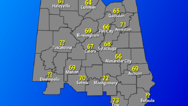
THURSDAY’S HIGHS: Most locations were a little cooler Thursday compared to Christmas Day, thanks to a little extra cloud cover. Here is a list of high temperatures across central Alabama:
- Alexander City — 66 degrees
- Anniston — 71
- Auburn — 69
- Birmingham — 69
- Calera — 67
- Cullman — 64
- Gadsden — 65
- Haleyville — 61
- Marion — 69
- Montgomery — 72
- Pell City — 66
- Selma — 70
- Sylacauga — 68
- Troy — 73

ISOLATED SHOWERS POSSIBLE: Ridging that has been in place over Alabama will break down today as moisture is pulled up from the Gulf of Mexico. We could see a few isolated showers across the southern two-thirds of the state, mainly along and south of the I-20 corridor. Highs will be in the mid-60s to the lower 70s. Rain chances will be around 20%.
THE ALABAMA WEEKEND: The European model and the Global Forecast System have come into better agreement on our next cold front that will affect Alabama during the weekend. A low will start off at daybreak Saturday in southwestern Kansas, moving northeast, and will end up in southern Minnesota at midday Sunday. Timing on this has slowed down; a few showers ahead of the cold front will enter western Alabama late Saturday. Highs will be in the upper 60s to the lower 70s.
On Sunday, the cold front continues to lag back before finally entering western Alabama by evening. Rain and thunderstorms will become likely in the west during the morning and slowly progress eastward throughout the day. A few strong storms are possible, with a very minimal severe weather threat throughout the day. Highs will be in the mid-60s to the lower 70s. Rainfall amounts look to be in the one-quarter inch to 1 1/4-inch range from southeast to northwest.
COOLER START FOR NEXT WEEK: Rain should be out of the area well before sunrise Monday, and skies will clear out nicely. We’ll end up with mostly sunny skies and much cooler temperatures. Highs look to top out in the mid-50s to the lower 60s.
NEW YEAR’S EVE AND DAY: Tuesday looks to start off very nice, but clouds will begin to move into Alabama during the late-night and overnight hours. Both the GFS and European models keep us dry through at least midnight. Afternoon highs will be in the lower to mid-50s, dropping into the upper 30s to the mid-40s by midnight.
The models go in completely different directions for the start of 2020 on Wednesday. The GFS has high pressure over the state keeping us dry the entire day. The European model has rain and storms throughout the day and not ending until late Thursday. I’ll go with the European model on this run and say showers and storms will be possible throughout Wednesday with afternoon highs in the 50s.
On Thursday, the GFS finally has rain moving into Alabama during late morning and persisting throughout the day. The European model has rain ending during late afternoon and early evening. I’ll side with the European again and say rain and storms will be likely through the daylight hours, ending after sunset. Highs will be in the mid-50s to the mid-60s.

VOODOO LAND: Highs will stay mainly in the 50s and 60s, with a couple of days holding in the 40s. Lows throughout the period will mostly be in the 40s and 50s, with a few in the 30s. This can and probably will change, as this is out in Voodoo Land.
BEACH FORECAST: Get the latest weather and rip current forecasts for the beaches from Bay St. Louis, Mississippi, to Panama City Beach, Florida, on our Beach Forecast Center page. There, you can select the forecast of the region you are interested in.
CONNECT: You can find us on the major social media networks:
Facebook
Twitter
Instagram
For more weather information from James Spann, Scott Martin and other members of the James Spann team, visit AlabamaWx.