James Spann: Rising heat levels for Alabama; strong storms Sunday

James Spann forecasts hotter and hotter weather for Alabama from Alabama NewsCenter on Vimeo.
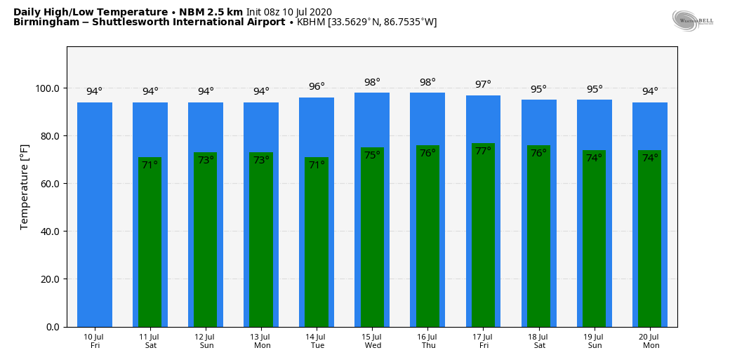
HOT, HUMID SUMMER WEATHER: Look for a high in the low 90s today and mid 90s Saturday as heat levels continue to rise across Alabama. The sky will be partly sunny both days, and while showers and thunderstorms are possible, they will be few and far between. On Sunday, a surface boundary will slice into the hot, humid, unstable air and will set the stage for strong, possibly severe thunderstorms. The Storm Prediction Center has roughly the northern two-thirds of the state in a marginal risk (level 1 of 5).
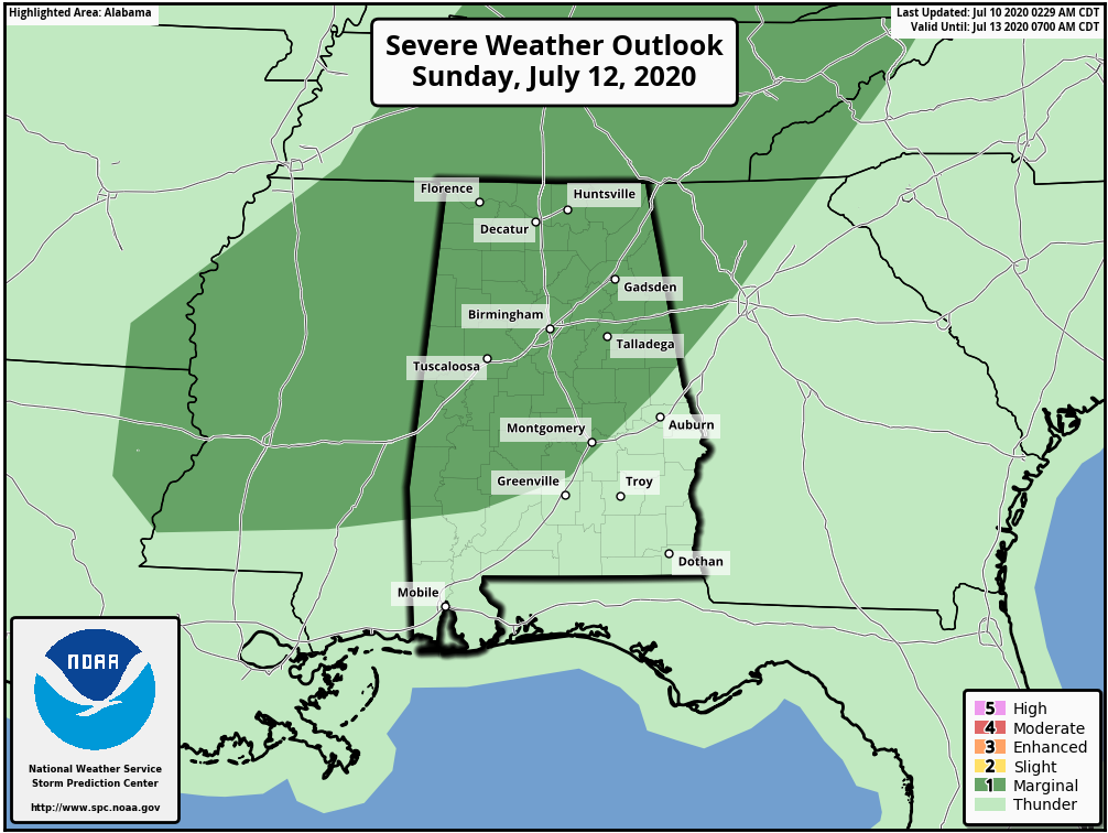
The main threat with thunderstorms Sunday will come from strong, potentially damaging winds, mainly during the afternoon and evening. Otherwise we expect a mix of sun and clouds with a high in the low 90s.
NEXT WEEK: No doubt it will be the hottest week so far in 2020. We expect highs in the 94- to 99-degree range through the week as an upper ridge builds over the region. The chance of a cooling shower is tiny Monday through Wednesday. A few widely scattered afternoon storms could pop up Thursday and Friday, but nothing widespread. The heat will be the big story.
TROPICS: Tropical Storm Fay is packing sustained winds of 50 mph and is just offshore near the Delmarva peninsula. A Tropical Storm Warning is in effect for Cape May, New Jersey, to Watch Hill, Rhode Island, including Long Island and Long Island Sound. The center will move inland tonight; it is expected to produce 2 to 4 inches of rain with isolated maxima of 7 inches along and near the track from the lower Maryland eastern shore and Delaware northward into New Jersey, eastern Pennsylvania, southeast New York and southern New England. These rains may result in flash flooding where the heaviest amounts occur.
The rest of the Atlantic basin, including the Gulf of Mexico, is very quiet.
ON THIS DATE IN 2005: Dennis made landfall as a Category 3 hurricane near Navarre Beach. The hurricane had reached Category 4 strength for the third time earlier in the day as it approached Florida, attaining its lowest barometric pressure of 27.46 inches. This ranked Dennis as the strongest hurricane in the Atlantic basin to form before August; however, this record was broken just six days later by Hurricane Emily, which surpassed Dennis and attained Category 5 status. In Alabama, sustained winds reached minimal hurricane force in the interior of the state. In total, 280,000 people in our state experienced power outages during the storm. No deaths occurred, although Dennis caused three injuries and total damage amounted to $127 million, mostly structural damage. There was also severe damage to cotton crops.
BEACH FORECAST: Click here to see the AlabamaWx Beach Forecast Center page.
WEATHER BRAINS: You can listen to our weekly 90-minute show anytime on your favorite podcast app. This is the show all about weather featuring many familiar voices, including the meteorologists at ABC 33/40.
CONNECT: You can find me on the major social networks:
Facebook
Twitter
Instagram
Pinterest
Snapchat: spannwx
For more weather news and information from James Spann and his team, visit AlabamaWx.


