Scott Martin: Potential tropical storm may affect Alabama Gulf Coast
THE ALABAMA WEEKEND: Deeper moisture and an easterly wave will be just to our west near the Mississippi River. With that proximity to Alabama, scattered to numerous showers and thunderstorms will be likely, mainly during the afternoon and evening. Showers and storms will also be possible during the morning, but chances will increase with the rising temperatures. Highs will be in the lower 90s.
We could see a lessening in our chance for showers and storms on Sunday with the approach of Tropical Depression 19, but rain chances will remain elevated, mainly for the afternoon and evening. Highs will be in the lower 90s.
THE WORK WEEK: Tropical moisture will begin moving into Alabama from the south along with the outer rain bands of TD-19 on Monday. Showers and storms will be likely mainly over the southern half of the state through much of the day, but those will eventually move northward. Highs will be in the mid to upper 80s.
As TD-19 makes landfall on the Louisiana and Mississippi Gulf Coast on Tuesday, we’ll continue to have tropical showers and storms across Alabama. We may have to watch for some stronger cells within those outer bands that may start to rotate and drop a quick spin-up tornado, but it is too early to be certain on that. Highs will be in the lower to mid-80s.
On Wednesday, the remnants of TD-19 will be pulled eastward across Alabama, bringing the greater potential for tropical showers and storms. Again, it looks like we may have to watch closely for rotating cells throughout the day. Highs will be in the upper 70s to the lower 80s.
The remnants of TD-19 will finally make their way into Georgia on Thursday, but tropical showers and storms will remain likely throughout the day across Alabama. If any severe weather occurs, it looks to be confined to eastern Alabama. Highs will be in the upper 70s to the lower 80s.
While showers and thunderstorms will remain possible Friday, much of the tropical moisture will be out of the area, leaving us with our standard rain chances for the afternoon and evening. Highs will be in the upper 70s to the mid-80s.
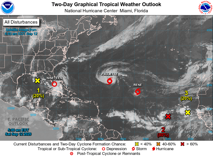
TROPICS: An area of showers and thunderstorms may develop a little more as it moves westward and southwestward over the Gulf of Mexico through the middle of the week, but is given only a small chance of developing into a depression within the next five days.
Another disturbance just off the coast of Africa may become a depression during the next few days, but conditions will become unfavorable for any further development by Tuesday.
Invest 95L, over the east-central parts of the tropical Atlantic Ocean, will likely become a depression over the next couple of days. It is projected to move generally westward for at least the next five days. Most of the ensemble members have it curving to the northwest well before reaching the Leeward Islands.
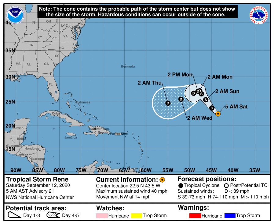
We also have Rene in the middle of the Atlantic, struggling to stay at tropical storm strength. Winds are at 40 mph and are expected to weaken into a depression by early Monday morning. We’ll have to watch and see what happens after the next five days, but, for now, he stays out to sea bothering the fish.
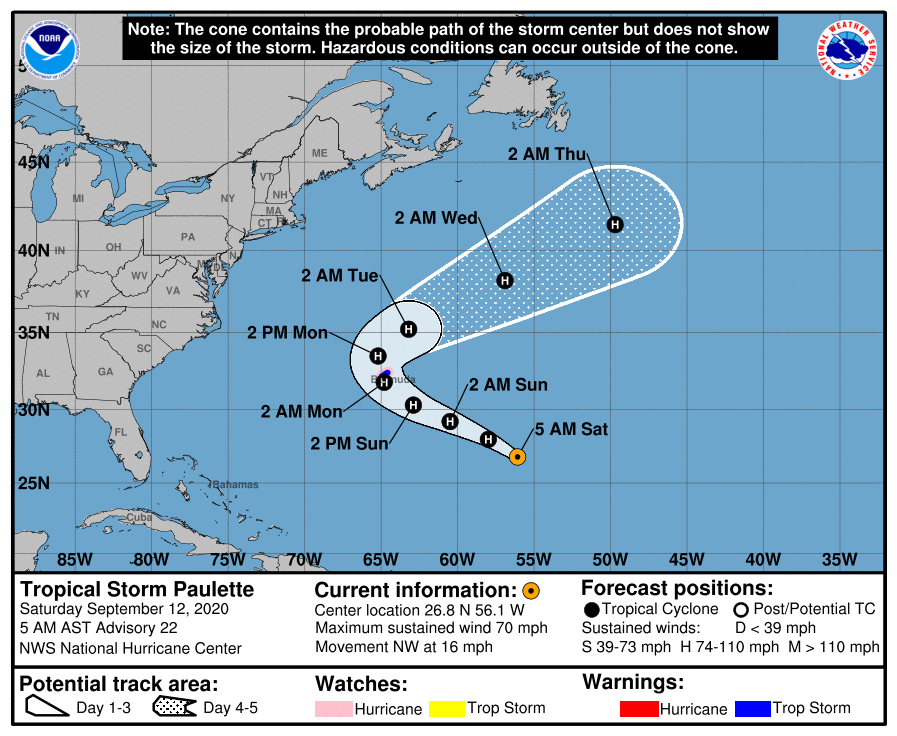
Tropical Storm Paulette is on a path toward Bermuda, packing winds at 70 mph and moving northwest at 16 mph. Additional strengthening is very likely and Paulette should become a hurricane later today. The center of Paulette is expected to move very close to Bermuda on Sunday night and Monday. Fortunately, Paulette will be out of there rather quickly and moving back out to open waters late Monday, expected to drop only 2-4 inches of rain on the island. Paulette is forecast to be a Category 2 hurricane with 100 mph winds as it passes over Bermuda.
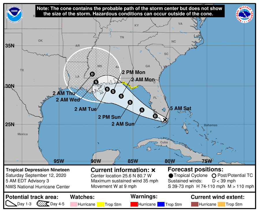
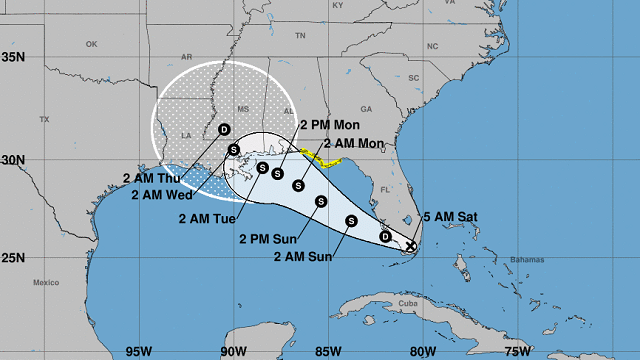
Then we get to the big story, Tropical Depression 19. Currently, maximum sustained winds are at 35 mph as the center is just 35 miles west-southwest of Miami. TD-19 is expected to move out over the Gulf of Mexico later today and will gradually start to intensify into a tropical storm, gaining the name Sally. The current forecast track has 19 moving west-northwest, passing very close to the Alabama Gulf Coast before making landfall very near the Louisiana-Mississippi state line.
Tropical storm watches are up for portions of the western Florida Gulf Coast and tropical storm conditions are likely by Sunday night in the watch locations. Rainfall totals of 2-4 inches with isolated spots reaching 6 inches are expected across the central Gulf Coast from Sunday through Tuesday morning. Rough surf and dangerous rip currents can be expected as well.
For more weather news and information from James Spann, Scott Martin and other members of the James Spann team, visit AlabamaWx.