James Spann: Arctic cold settles into Alabama; snow dusts parts of state
James Spann forecasts a below-freezing day for much of Alabama from Alabama NewsCenter on Vimeo.
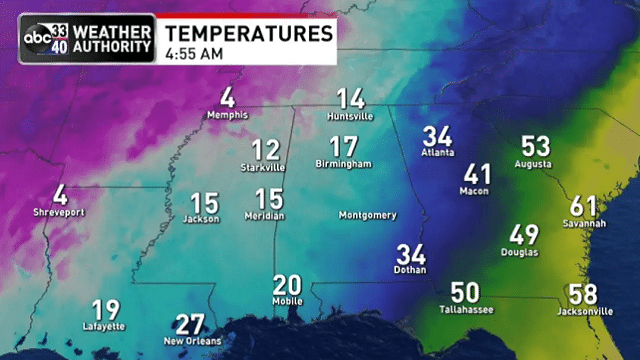
FRIGID AIR: Temperatures are generally between 10 and 18 degrees over the northern half of Alabama this morning. We even had a hard freeze down to the Gulf Coast; Mobile reported 20 degrees just before daybreak. Snow flurries overnight have provided a “dusting” to almost 1 inch this morning for many areas, and between that and black ice travel is very difficult in many areas. Unfortunately, temperatures won’t go above freezing over north Alabama today, but at least we expect to see some sun at times.
Tonight will bring another hard freeze, with lows mostly between 15 and 22 degrees.
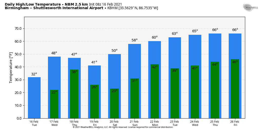
THE NEXT STORM SYSTEM: Clouds will increase across the state Wednesday as temperatures rise into the 40s. Rain is likely Wednesday night into part of the day Thursday. That precipitation, however, will likely fall in the form of sleet, some freezing rain and maybe a few snowflakes over northwest Alabama Wednesday night — a “wintry mix.”
Some light accumulation will be possible Wednesday night where the wintry mix develops. Impacts will be heavily dependent on the surface temperatures, which will be hovering around freezing. Temperatures are expected to rise into the mid upper 30s and low 40s on Thursday, preventing long-term impacts. The counties with potential for some impact Wednesday night include Marion, Winston, Franklin, Colbert, Lauderdale, Lawrence, Morgan, Limestone and Madison. For the rest of the state, it will be just rain.
Rain will end Thursday afternoon, and a few snow flurries are possible on the back side of the system Thursday night, but for now no accumulation is expected. Friday will be cold and dry with a clearing sky; the high will be between 38 and 44 degrees.
THE ALABAMA WEEKEND: Expect a nice warming trend with a good supply of sunshine both days. The high will be in the low 50s Saturday, followed by low 60s Sunday.
NEXT WEEK: We get a nice break from the cold air; highs will be in the 60s. Showers are possible with a cold front Monday and then again Friday.
ON THIS DATE IN 1989: A surge of Arctic air produced all-time record high barometric pressure readings of 31.08 inches at Duluth, Minnesota, 30.97 inches at Chicago and 30.94 inches at South Bend, Indiana. Readings of 31 inches at Milwaukee and 30.98 inches at Rockford, Illinois, tied their all-time records. Unseasonably warm weather prevailed across the Southeast. Highs of 81 degrees at Athens, Georgia, 87 degrees at Charleston, South Carolina, 85 degrees at Macon, Georgia, and 86 degrees at Savannah, Georgia, were records for February.
BEACH FORECAST: Click here to see the AlabamaWx Beach Forecast Center page.
WEATHER BRAINS: You can listen to our weekly 90-minute show anytime on your favorite podcast app. This is the show all about weather featuring many familiar voices, including the meteorologists at ABC 33/40.
CONNECT: You can find me on the major social networks:
For more weather news and information from James Spann and his team, visit AlabamaWx.


