High-risk area expanded in Alabama; severe weather outbreak imminent
SEVERE WEATHER OUTBREAK IMMINENT: A very dangerous and life-threatening tornado outbreak is about to occur across the Deep South, including portions of Alabama. Be ready to take immediate action as large hail, destructive winds to 80 mph and tornadoes — including some violent, long-track ones — will occur. Currently temperatures are surging into the 70s and 80s across the state, along with gusty winds of 25-35 mph not associated with storms, and a Wind Advisory is in effect.
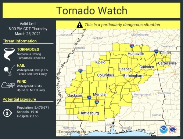
A Particularly Dangerous Situation (PDS) Tornado Watch is in effect until 8 p.m. for much of north and central Alabama.
COUNTIES INCLUDED
- In north Alabama — Colbert, Cullman, DeKalb, Franklin, Jackson, Lauderdale, Lawrence, Limestone, Madison, Marshall and Morgan.
- In central Alabama — Bibb, Blount, Calhoun, Cherokee, Chilton, Dallas, Etowah, Fayette, Greene, Hale, Jefferson, Lamar, Marengo, Marion, Perry, Pickens, Shelby, St. Clair, Sumter, Talladega, Tuscaloosa, Walker and Winston.
- In south Alabama — Choctaw, Clarke, Washington and Wilcox.
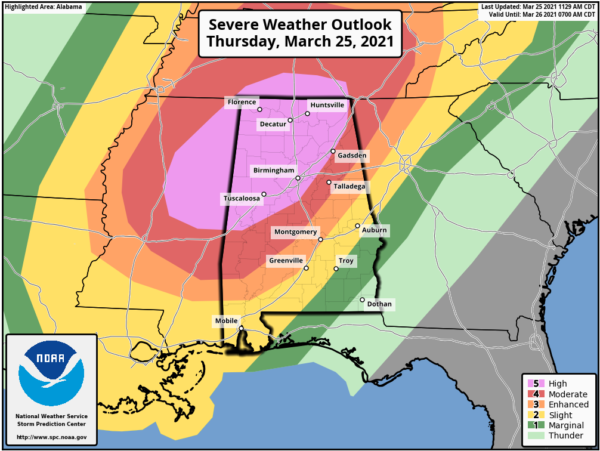
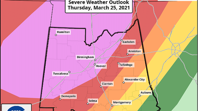
PLACEMENT: The midday update from the Storm Prediction Center expands the high risk (level 5 of 5) up for much of central Alabama and now includes Birmingham, Tuscaloosa and Gadsden, with a moderate risk (level 4 of 5) down to Anniston to Selma to Jackson. The enhanced risk (level 3 of 5) extends as far south as Alexander City, Montgomery and Monroeville, with the other risk levels farther to the south and east.
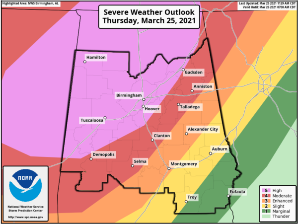
Don’t focus on the lines or colors on the maps. All of Alabama is under the threat for severe storms the rest of today. The storms can produce a tornado in a marginal risk area just like they can in a high or moderate risk area.
THE SETUP: A very dynamic storm system with a negatively tilted upper-air trough is causing the surface low to deepen as it approaches Alabama. A very warm, unstable and volatile atmosphere is in place due to surging instability values, strong wind fields aloft, high shear values and steep lapse rates, providing an environment very favorable for explosive thunderstorm development across Alabama and the Deep South.
THREATS: Thunderstorms will be capable of producing large hail, damaging winds up to 80 mph and tornadoes. Some violent, long-track tornadoes are very possible, especially in the high and moderate risk areas, but, again, all of Alabama is under the threat for severe storms during this event.
TIMING: From now through midnight is when the core threat for severe storms will be across northwest, west and central Alabama.
FLOODING: With recent rain and more expected, there will be some issues with flooding and flash flooding. The heaviest rain with this event will come over the Tennessee Valley of north Alabama, where some places could see 2-4 inches of rain. For the rest of the state, amounts will be around 1-2 inches. But some locations, as we have already seen this morning, could receive higher amounts.
CALL TO ACTION: Be ready to act immediately. Have multiple, reliable ways to receive severe weather alerts; never, ever, ever rely on a siren. Every Alabama home and business needs a NOAA Weather Radio (the most popular model is the Midland WR-120, which is sold in most big box retailers). The other way is your phone; be sure emergency alerts are enabled (look under settings and notifications) and install the free ABC 33/40 Weather app.
Know the safe place in your house, and in that safe place have helmets for everyone. Bicycle helmets and batting helmets work well. We also recommend portable air horns and hard-soled shoes for everyone. If you live in an apartment complex, you can’t be above the first level. Shelter with a friend on the ground level or ask management to open the clubhouse during a tornado warning.
If you live in a mobile home, you can’t stay there during a tornado warning. They offer little to no protection from severe storms. Know the location of the nearest shelter or business that is open 24/7. Know how to get there quickly.
BE A HERO: You can help us. Tell your friends, neighbors and relatives about the threat and what they need to do to get ready. If they fall in a tornado warning polygon, call them or text them to let them know about the threat. You are our most valuable resource in spreading the word.
Many of you have anxiety about severe weather, especially those who have gone through tornadoes or other kinds of violent weather. Have comfort knowing that even on the biggest severe weather days, odds of any one home being hit by a tornado are very low. But you have to pay attention and be prepared. We will get through the day together.
For more weather news and information from James Spann, Ryan Stinnett and other members of the James Spann team, including current warnings for specific areas, visit AlabamaWx.


