James Spann: Strong to severe storms for Alabama Wednesday, then much colder
James Spann: Strong or severe storms for Alabama Wednesday followed by drop in temperatures from Alabama NewsCenter on Vimeo.
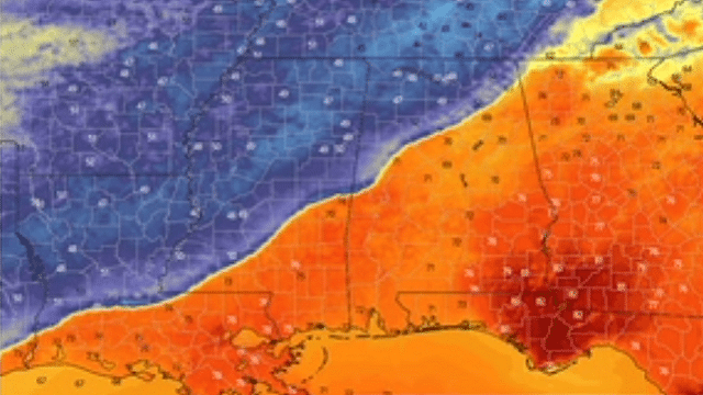
CHANGES AHEAD: Clouds will increase across Alabama today ahead of a cold front; a few showers will likely develop this afternoon and tonight. Then, on Wednesday, thunderstorms just ahead of the front could become strong to severe. There is a major National Weather Service data/web outage this morning, so the Storm Prediction Center outlook is not available, but I would imagine much of the state will be in a marginal or slight risk (levels 1-2 out of 5).
The main threat with the line of thunderstorms Wednesday will be strong, potentially damaging winds. Pay attention to severe thunderstorm warnings, since strong winds could easily knock down trees with the saturated soil conditions we have across Alabama. Some small hail is also possible with the heavier thunderstorms. A brief, isolated tornado is possible in spots, but not especially likely. Rain amounts of around 1 inch are likely.
Once the front passes, temperatures will fall quickly through the 50s and into the upper 40s with a brisk north wind. For some in central Alabama, temperatures will fall from around 70 degrees at midday Wednesday into the 47- to 52-degree range by 4-5 p.m. It will be a sharp, noticeable change.
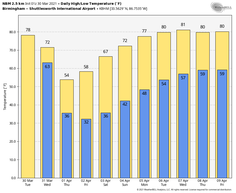
LATE-SEASON FREEZE AHEAD: We are projecting a low around 30 degrees Thursday morning, and between 23 and 32 degrees early Friday, when the wind will be light. The sky will be sunny both days with highs between 55 and 59 degrees, well below average for early April. Will this be the last freeze of the season? Possibly, but we have experienced a freeze as late as April 23.
The weekend ahead will be dry with a warming trend. Expect a good supply of sunshine both days. The high will be in the mid 60s Saturday, followed by low 70s Sunday.
NEXT WEEK: The first half of the week will be dry; temperatures will be close to 80 by Tuesday and Wednesday. Showers and storms return by Thursday and Friday; it’s too early to know whether severe thunderstorms will be an issue.
SURVEY UPDATE: National Weather Service Birmingham has confirmed 10 tornadoes in its County Warning Area last Thursday. Four of them were rated EF-3. One of them was on the ground for 80 miles; it first touched down near Sawyerville in Hale County and lifted near Wilsonville. The path was very similar to the May 27, 1973 tornado; both hit the NWS radar site near Brent (it was decommissioned in the mid 1990s).
BEACH FORECAST: Click here to see the AlabamaWx Beach Forecast Center page.
WEATHER BRAINS: You can listen to our weekly 90-minute show any time on your favorite podcast app. This is the show all about weather featuring many familiar voices, including the meteorologists at ABC 33/40.
CONNECT: You can find me on the major social networks:
For more weather news and information from James Spann and his team, visit AlabamaWx.


