James Spann: Alabama mostly dry through Friday; watching the Gulf
James Spann forecasts a mostly dry week for Alabama from Alabama NewsCenter on Vimeo.
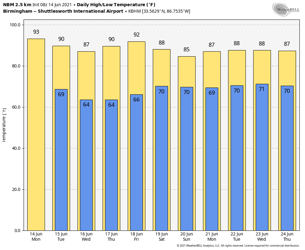
A CHANCE TO DRY OUT: While we have a couple of rogue showers near Birmingham and Tuscaloosa early this morning, most of the day will be dry across Alabama as precipitable water values will be coming down. The chance of any one spot seeing a shower this afternoon is only 5-10%, and with a partly to mostly sunny sky we expect a high in the low 90s this afternoon. The average high for Birmingham on June 14 is 88.
REST OF THE WEEK: We are forecasting partly to mostly sunny days, fair nights and only very isolated showers during the afternoon and evening hours Tuesday through Friday. Highs will be mostly between 86 and 90 degrees with lows in the 60s. Some of the cooler spots over the northern half of the state might even reach the upper 50s early Wednesday and Thursday mornings thanks to the drier air. It will be a welcomed chance to dry out.
THE ALABAMA WEEKEND: We will bring in a chance of scattered showers and thunderstorms Saturday over the northern half of the state as tropical moisture begins to increase, and Sunday could very well be wet much of the day as a tropical low moves into Louisiana. There is considerable uncertainty in the forecast track and timing of the tropical system, and this forecast could change. Highs over the weekend will be in the 80s.
NEXT WEEK: We will maintain an enhanced chance of rain in the forecast Monday with the tropical system nearby; showers and storms should become more scattered in nature over the latter half of the week. Highs will be mostly in the mid to upper 80s.
TROPICS: The National Hurricane Center is monitoring two areas this morning. A well-defined, non-tropical low-pressure system is about 120 miles south of Cape Hatteras, North Carolina, in the Atlantic. Satellite and radar data indicate that thunderstorm activity has continued to increase and become more concentrated near the center of the low early this morning, and environmental conditions are expected to be at least marginally conducive for tropical cyclone formation. If this recent development trend continues, then a short-lived tropical depression or tropical storm could form later today while the system moves northeastward away from the United States. The low will move over colder waters south of Nova Scotia on Wednesday, ending any opportunity for further development.
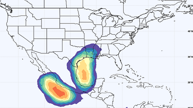
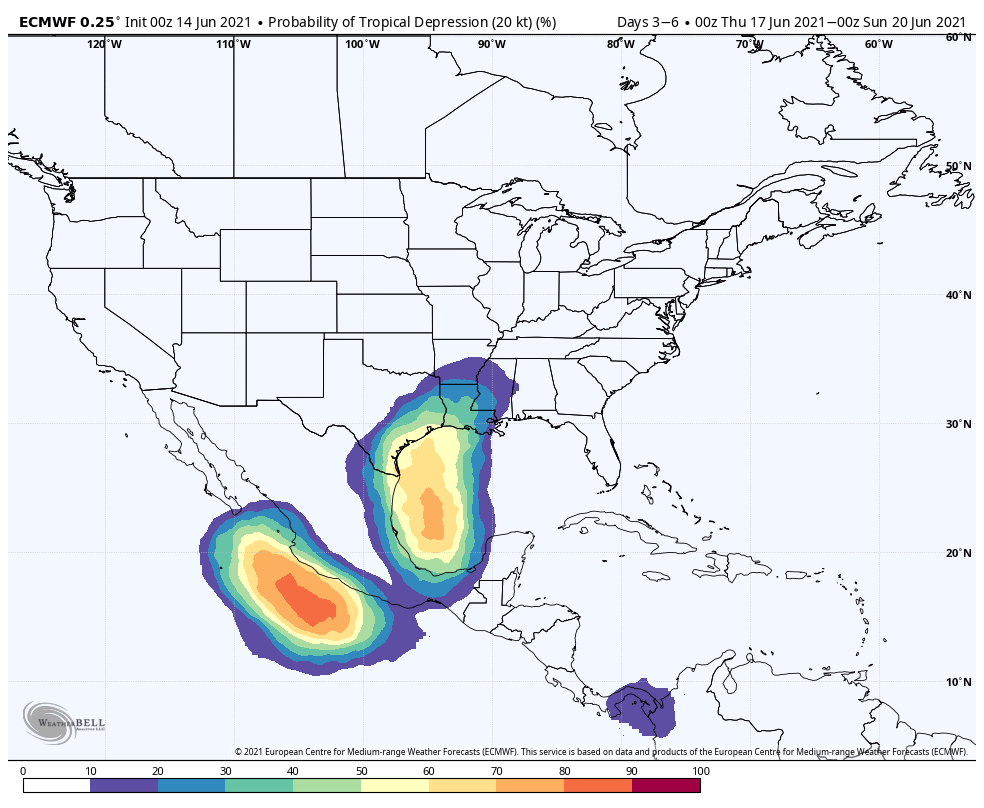
Of more interest to Alabamians is the disturbance in the Bay of Campeche in the far southwest Gulf of Mexico. This is forecast to become a tropical depression late this week as it moves slowly northward. This has potential to bring lots of rain and a high rip-current danger to the Gulf Coast from Galveston to the Florida Panhandle six to eight days from now. There is potential for the system to become a tropical storm, but for now it looks like the main threat will come from rain, flooding and rip currents. Interests along the Gulf Coast will need to keep an eye on this one.
RAIN UPDATE: Here are rain totals since Jan. 1, and the departure from average:
- Mobile — 32.87 inches (3.4 inches above average)
- Muscle Shoals — 32.62 (6.5 above average)
- Huntsville — 31.65 (4.96 above average)
- Tuscaloosa — 31.53 (5.84 above average)
- Birmingham — 30.41 (2.77 above average)
- Montgomery — 24.83 (0.56 above average)
- Anniston — 23.4 (2.52 below average)
ON THIS DATE IN 1903: Major flash flooding along Willow Creek destroyed a significant portion of Heppner, Oregon. With a death toll of 247 people, it remains the deadliest natural disaster in Oregon.
BEACH FORECAST: Click here to see the AlabamaWx Beach Forecast Center page.
WEATHER BRAINS: You can listen to our weekly 90-minute show any time on your favorite podcast app. This is the show all about weather featuring many familiar voices, including the meteorologists at ABC 33/40.
CONNECT: You can find me on the major social networks:
For more weather news and information from James Spann and his team, visit AlabamaWx.


