James Spann: Alabama showers, storms thin out a bit in coming days
RADAR CHECK: We have numerous showers and thunderstorms across Alabama this afternoon. The stronger storms are producing very heavy rain, gusty winds and lots of lightning. The Storm Prediction Center maintains a low-end, marginal risk (level 1 out of 5) of severe thunderstorms for much of the state through the evening.
Away from the storms, we have a mix of sun and clouds with temperatures mostly in the low to mid 80s, about 10 degrees below average for mid-July in Alabama. Storms will fade away after sunset.
REST OF THE WEEK: Warm, humid weather continues with the ocean of humidity across the Deep South. We do believe showers and storms will thin a bit through midweek; odds of any one spot getting wet will drop to 30-40% Tuesday through Thursday. Most (but not necessarily all) of the showers will come from about 1 until 11 p.m.
Another trough will approach Friday, and an increase in the number of showers and storms is likely, but it won’t be a washout or all-day kind of rain. Highs will remain in the 80s for the rest of the week.
THE ALABAMA WEEKEND: Look for a mix of sun and clouds Saturday and Sunday with scattered showers and storms both days, especially during the afternoon and evening hours. The chance of any one location getting wet both days is 55-65%, and highs will be mostly between 85 and 89 degrees. Humidity levels stay high.
NEXT WEEK: We will maintain a persistence forecast — partly sunny, warm, humid days with the usual threat of scattered showers and storms, mostly between 1 and 11 p.m. Temperatures remain below average, with highs generally in the mid to upper 80s.
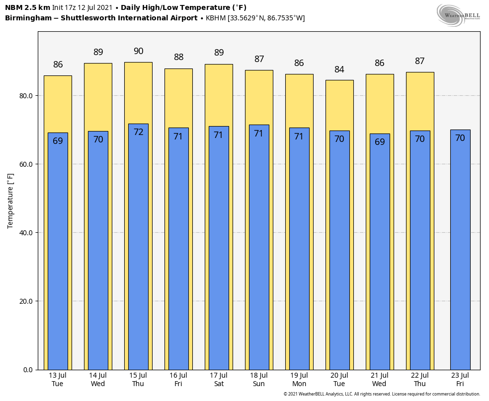
LOWER HEAT LEVELS THIS SUMMER: Temperatures have reached 90 degrees on only 10 days in Birmingham since June 1. The average high for June was 86 degrees, 2 degrees below average, and so far the average high for July is 87 degrees, which is 3 degrees below average. Our hottest temperature so far is 94, recorded on June 14. On the morning of June 23, the official low was 60, but many places across north and central Alabama dropped into the 50- to 55-degree range.
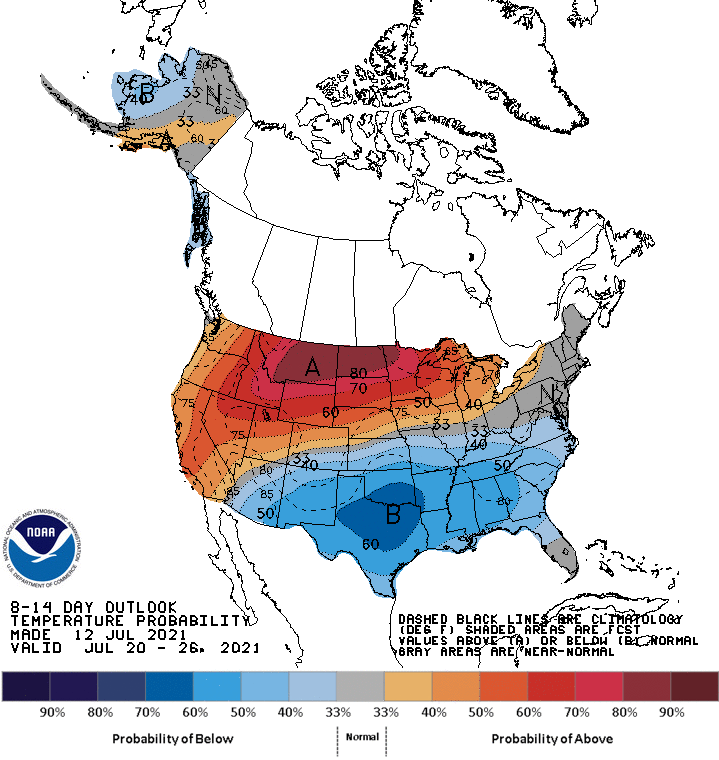
The Climate Prediction Center continues to forecast below-average temperatures for the southern U.S. in its outlook for July 19-25.
TROPICS: All is quiet across the Atlantic basin thanks to dry air and subsidence (sinking air), and tropical storm formation is not expected at least for the next five days.
ON THIS DATE IN 1995: An intense heat wave affected much of the Midwest for four days beginning on this day. The worst effects were noted in the Chicago metropolitan area, where 583 people died from the heat. Temperatures across the region reached as high as 104 degrees, with overnight lows falling only to the upper 70s to low 80s. Dew point temperatures in the upper 70s to low 80s created heat indexes peaking at 125 degrees. Electricity and water usage reached record levels, causing periodic outages.
ON THIS DATE IN 1996: Hurricane Bertha made landfall near Wrightsville Beach, North Carolina, with maximum winds of 105 mph, but the storm surge dealt the most devastation. The U.S. Virgin Islands, along with North Carolina, were declared federal disaster areas. Surveys indicate that Bertha damaged almost 2,500 homes on St. Thomas and St. John. For many, it was the second hit in the 10 months since Hurricane Marilyn devastated the same area. The primary effects in North Carolina were to the coastal counties and included storm surge flooding and beach erosion, roof damage, piers washed away, fallen trees and damage to crops.
BEACH FORECAST: Click here to see the AlabamaWx Beach Forecast Center page.
WEATHER BRAINS: You can listen to our weekly 90-minute show any time on your favorite podcast app. This is the show all about weather featuring many familiar voices, including the meteorologists at ABC 33/40.
CONNECT: You can find me on the major social networks:
For more weather news and information from James Spann and his team, visit AlabamaWx.