James Spann: Scattered showers, storms for Alabama later today; watching Fred
James Spann forecasts more classic Alabama summer weather from Alabama NewsCenter on Vimeo.
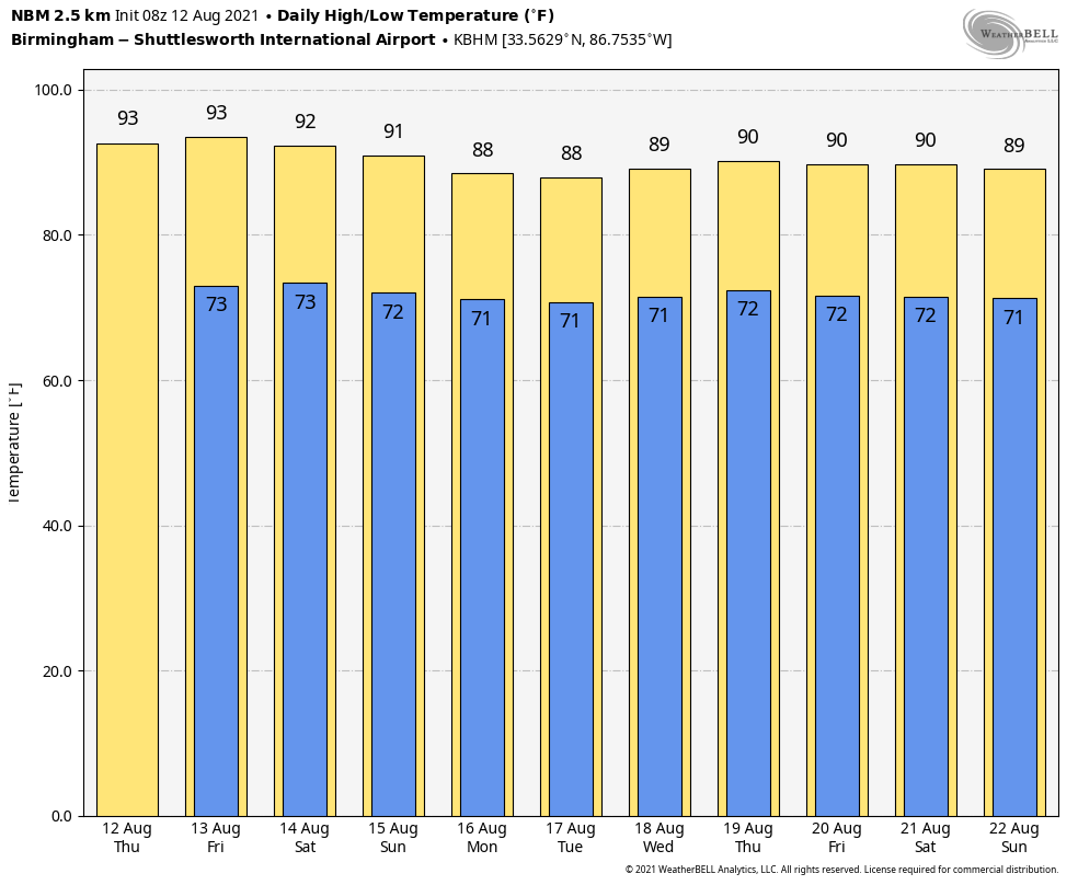
SUN, HEAT, STORMS: Alabama’s weather won’t change much through the beginning of the weekend. Expect hot, humid days with highs in the low 90s, and scattered showers and thunderstorms daily, mostly between noon and 10 p.m. Like Wednesday, some spots will see heavy rain and some places won’t get a drop. Odds of any one spot seeing rain each day are 35-45%. Coverage of showers and storms could be a little higher by Sunday, especially over the southeast part of the state, as deeper tropical moisture spreads northward.
NEXT WEEK: A tropical system will likely pull higher precipitable water values into the state, so scattered to numerous showers and storms are likely Monday through Wednesday, although the heaviest rain is expected to be east of Alabama. Temperatures next week are expected to be below average; highs will generally be in the mid to upper 80s.
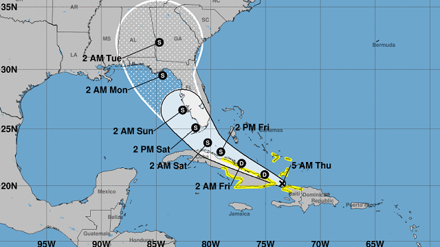
EYES ON FRED: Fred is a disorganized tropical depression this morning; it was pretty much shredded by Hispaniola Wednesday. The system will move near the northern coast of Cuba later today through Friday, slowly regaining tropical storm strength. The latest National Hurricane Center forecast track has Fred moving over the far eastern Gulf of Mexico over the weekend, making landfall near Carrabelle, Florida, Sunday night as a tropical storm.
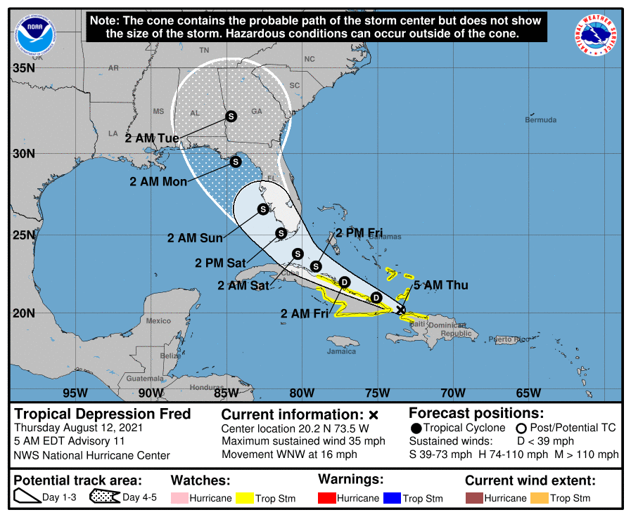
Here are some notes on Fred:
- The system is expected to remain below hurricane strength in the Gulf due to interaction with the Florida peninsula and southwest winds aloft creating shear over the system.
- The main wind, rain and storm surge impact will be east of the circulation center, over the Florida peninsula and north Florida. Most of the Florida Panhandle and the Alabama Gulf Coast is expected to be on the “good,” drier, west side of the system (places like Gulf Shores, Orange Beach, Pensacola, Navarre Beach, Destin and Panama City Beach). However, in those places the rip current danger will be high Sunday and Monday, and there will be some rain.
- The heaviest rain in association with Fred is expected to be east of Alabama, over the Florida peninsula, Georgia and the Carolinas. Still, deeper tropical moisture will be pulled into the state with higher rain coverage Sunday into early next week.
- I can’t give specific advice on beach trip plans since different people go to the beach for different reasons. The main impact of Fred is expected to be east of the central Gulf Coast (east of Panama City Beach), but there will be some rain and a high rip current danger.
- This forecast can change. If you are working with old information on tropical systems, you are working with bad information.
Elsewhere in the tropics, showers and thunderstorms remain disorganized in association with a tropical wave (Invest 95L) about 1,500 miles east of the Lesser Antilles. Environmental conditions are expected to gradually become more conducive for development, and a tropical depression could form by early next week while the system moves generally westward at about 20 mph across the tropical Atlantic. This system is expected to reach portions of the Leeward Islands late Saturday or early Sunday. If this becomes a tropical storm, the name will be Grace.
ON THIS DATE IN 2005: A tornado struck Wright, Wyoming, a coal-mining community, killing two, destroying 91 homes and damaging about 30 more around the town.
BEACH FORECAST: Click here to see the AlabamaWx Beach Forecast Center page.
WEATHER BRAINS: You can listen to our weekly 90-minute show any time on your favorite podcast app. This is the show all about weather featuring many familiar voices, including the meteorologists at ABC 33/40.
CONNECT: You can find me on the major social networks:
For more weather news and information from James Spann and his team, visit AlabamaWx.


