James Spann: Nice warm-up for Alabama today; dry through Friday
James Spann forecasts warming weather for Alabama through the work week from Alabama NewsCenter on Vimeo.
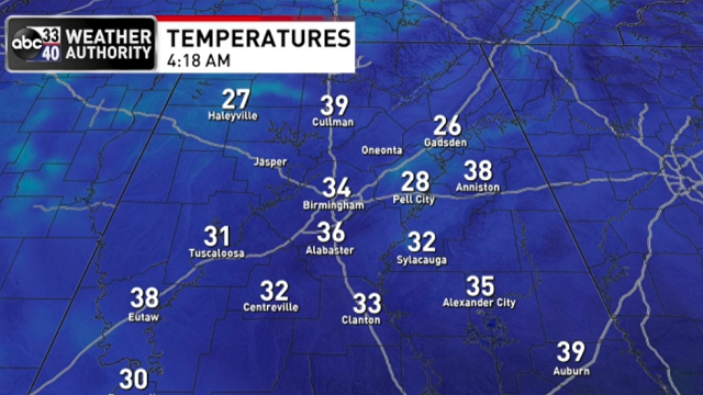
COLD START: Here are some temperatures across Alabama just before sunrise this morning:
- Gadsden — 26
- Haleyville — 27
- Black Creek — 27
- Pell City — 28
- Scottsboro — 28
- Muscle Shoals — 29
- Decatur — 29
- Trussville — 30
- Talladega — 30
- Demopolis — 30
- Sylacauga — 32
- Selma — 32
- Birmingham — 33
- Huntsville — 33
- Tuscaloosa — 33
- Montgomery — 36
- Anniston — 39
- Mobile — 43
- Dothan — 48
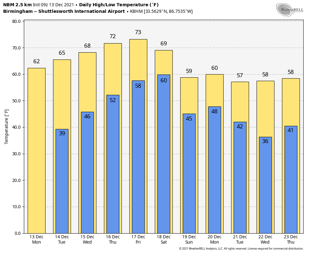
Look for a nice warm-up today; with sunshine in full supply, temperatures reach the 60s this afternoon.
REST OF THE WEEK: Dry weather will continue for the rest of the week with a warming trend. The sky will stay sunny Tuesday and Wednesday; we reach the mid 60s Tuesday, and the high will be near 70 Wednesday afternoon.
Moisture levels will begin to rise Thursday and Friday, but for now it looks like the upper ridge over the Gulf Coast will keep showers north of Alabama on these two days. The weather will be unseasonably mild, with highs in the low to mid 70s both days.
THE ALABAMA WEEKEND: The ridge weakens, allowing a cold front to approach. The sky will be mostly cloudy Saturday and Sunday, and showers are likely statewide both days. It won’t be a total washout, but if you have an event planned outdoors be ready for occasional showers. There will be some instability Saturday over the southern half of the state, so thunder is possible there, but severe storms are not expected. The high will be in the mid 60s Saturday, followed by low 60s Sunday. Some north Alabama communities won’t get out of the 50s Sunday afternoon.
NEXT WEEK: For now, most of the week looks dry. Temperatures should be near or a bit above seasonal averages, with highs between 57 and 62 degrees. There is a decent chance the weather stays quiet for the Christmas weekend, but it’s a bit too early for a specific forecast.
 ALABAMA TORNADO: Survey teams determined that a brief EF-0 tornado touched down in Elmore County Friday afternoon on the northern side of Albritton Lane, just northeast of Montgomery and southeast of Wetumpka. The parent thunderstorm produced a well-defined wall cloud over eastern Montgomery before the brief tornado touched down.
ON THIS DATE IN 1962: A cold wave covered the Deep South; Birmingham’s official low was 1 degree. The day before, on Dec. 12, 1962, the high was only 13 degrees, the lowest maximum temperature on record.
ON THIS DATE IN 1997: A freak cold snap and snowstorm struck parts of northern Mexico, leaving 12 people dead and the area paralyzed. It snowed in the city of Guadalajara for the first time since 1881, leaving amazed residents to gawk at the white stuff and make snowmen. The temperature plunged to 5 degrees in Chihuahua.
BEACH FORECAST: Click here to see the AlabamaWx Beach Forecast Center page.
WEATHER BRAINS: You can listen to our weekly 90-minute show any time on your favorite podcast app. This is the show all about weather featuring many familiar voices, including the meteorologists at ABC 33/40.
CONNECT: You can find me on the major social networks:
For more weather news and information from James Spann and his team, visit AlabamaWx.


