James Spann: Wintry mix for the Tennessee Valley in Alabama Thursday
James Spann has the midweek forecast for Alabama from Alabama NewsCenter on Vimeo.
COOL, DRY TODAY: Clouds will increase across Alabama today, but the weather will stay dry with a high in the mid 50s. The average high for Birmingham on Jan. 5 is 54.
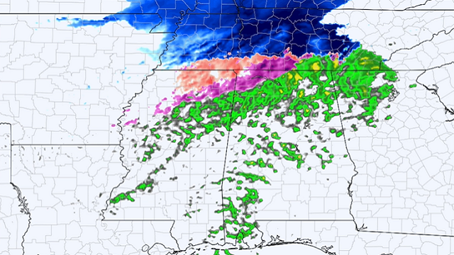
THURSDAY: On Thursday most of the state will see periods of light rain, and another shot of very cold air moves into the state. There will be potential for freezing or frozen precipitation over parts of north Alabama.
The forecast is complex for the northern third of the state. As the precipitation begins Thursday morning, a period of sleet or freezing rain is possible due to evaporative cooling and cold air advection. Then, after a change to a cold rain, precipitation could change back to freezing rain or sleet again by afternoon as cold air deepens. A few snow flakes could be in the mix before it all ends Thursday evening.
This chance of wintry precipitation is mainly north of a line from Millport to Cullman to Scottsboro. The highest chance of travel impact (icy bridges) will be along and north of the Tennessee River, however. A few snow flurries are possible Thursday evening as far south as I-20, but we expect no impact for places like Tuscaloosa, Birmingham, Anniston and Gadsden at this point.
Temperatures will fall through the 30s over north Alabama Thursday afternoon.
FRIDAY AND THE WEEKEND: Friday morning will feature the coldest temperatures so far this season for most of the state. We project lows between 18 and 24 degrees, with a wind chill index as low as 10 degrees. During the day Friday, the sky will be sunny with a high between 37 and 41 degrees.
Saturday will be mostly sunny; after a low in the 20s temperatures rise into the 50s by afternoon. Rain returns to the state Sunday ahead of the next cold front. Temperatures could reach the low 60s Sunday afternoon before the next shot of cold air rolls in.
NEXT WEEK: Rain will end before dawn Monday. The sky will clear during the day with a high in the 40s. Tuesday and Wednesday will be dry; then another disturbance brings a chance of rain late Thursday and Thursday night.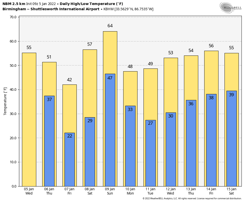
ON THIS DATE IN 1892: From the History of Fayetteville, Georgia, “Another traumatic event occurred in Fayetteville on Jan. 5, 1892, about 6 o’clock in the evening. A terrible tornado or cyclone struck the town of Fayetteville just as many had sat down for dinner. The storm killed three people and injured many more as its raging force destroyed numerous residences, outbuildings and structures, including the academy, as well as killing abundant livestock. The event was written about as far away as Savannah.”
ON THIS DATE IN 1962: Two tornadoes, about 100 yards apart and each making paths about 100 yards wide, followed parallel paths from southeast to northwest through the edge of the Crestview, Florida, residential area. These tornadoes killed one and injured 30 others.
BEACH FORECAST: Click here to see the AlabamaWx Beach Forecast Center page.
WEATHER BRAINS: You can listen to our weekly 90-minute show any time on your favorite podcast app. This is the show all about weather featuring many familiar voices, including the meteorologists at ABC 33/40.
CONNECT: You can find me on the major social networks:
For more weather news and information from James Spann and his team, visit AlabamaWx.


