Scott Martin: Hot, humid and mainly dry in Alabama today
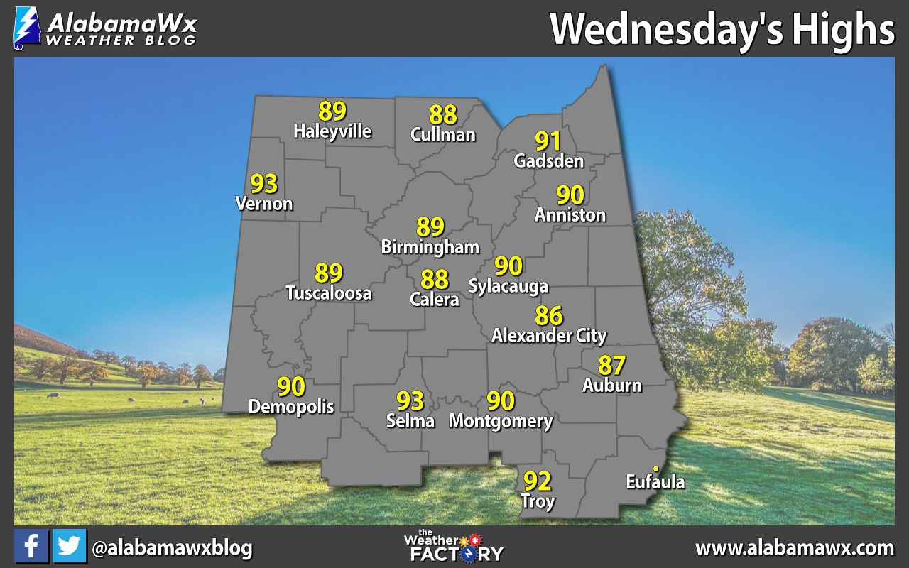
WEDNESDAY’S HIGHS: We’ll start off by taking a look at Wednesday’s highs in central Alabama. Selma and Vernon were the hot spots at 93 degrees. The cool spot was Alexander City at 86. The Birmingham Airport made it up to 89.
TODAY AND FRIDAY: Hot and humid will be the story as we’ll have mostly sunny skies with only a small chance of a few isolated showers. Highs will be in the lower to mid 90s.
Friday’s weather looks very similar, hot with mostly sunny skies. There is a small risk of a shower, but nearly everyone should remain dry. Highs will be in the lower to mid 90s.
THE ALABAMA WEEKEND: Rain chances will be a little higher Saturday, especially in the late afternoon through the evening as scattered showers and storms fire up. Highs will be in the lower to mid 90s.
Strong ridging over the Atlantic will bring an uptick to the scattered shower and thunderstorm chances from Sunday afternoon through predawn Monday; however, not everyone will see rain. Highs will be in the upper 80s to the mid 90s.
MONDAY THROUGH WEDNESDAY: Rain chances will stay elevated Monday as a frontal system starts to head in our direction, trapping moisture over Alabama. Scattered showers and storms will be possible, especially west of the I-65 corridor. Highs will be in the upper 80s to the lower 90s.
The front slowly creeps southeastward toward the state on Tuesday, but it will continue to hang out just to our northwest. Ahead of the front, a good chance of scattered showers and storms will be possible for northern and western Alabama, while the rest will have a smaller rain chance. Highs will be in the mid 80s to the lower 90s.
On Wednesday, the frontal boundary moves into northwestern Alabama. That will make showers and thunderstorms likely at times throughout the day, especially with the main heating of the day. A few strong storms may be possible, with gusty winds and some hail. It’s too early to know whether there will be a threat of severe storms. Highs will be in the mid 80s to the lower 90s.
TROPICS: All remains calm across the Gulf of Mexico, the Caribbean Sea and the tropical Atlantic Ocean, and no new tropical systems are expected to form over the next five days.
For more weather news and information from James Spann, Scott Martin and other members of the James Spann team, visit AlabamaWx.