James Spann: Warm weekend ahead for Alabama; much colder next week
SEVERE CLEAR: We have a cloudless sky across Alabama this afternoon with temperatures mostly in the mid to upper 70s; a few spots have reached 80 degrees. The weekend will be warm and dry; look for a good supply of sunshine Saturday and Sunday with highs between 80 and 85 degrees, about 7-10 degrees above average for mid-October in Alabama.
NEXT WEEK: We will mention the chance of a few isolated showers Sunday night and early Monday with a cold front, but moisture will be very limited, and most places will stay dry. The big story is the coldest air so far this season rolling into the state. By Tuesday expect a high between 54 and 59 degrees with a very cool north breeze. Temperatures will drop into the 25- to 35-degree range early Wednesday and Thursday mornings over the northern two-thirds of the state; for many places it will be the first freeze of the season. Frost will be widespread, even down into parts of south Alabama. Temperatures begin to warm up late in the week, with highs back in the low 70s by Friday, and the week will be rain-free.
 FOOTBALL WEATHER: Expect another perfect night for high school football games across Alabama tonight; the sky will be clear with temperatures falling from the mid 70s at kickoff into the 60s by the second half.
Saturday Auburn travels to Oxford to play Ole Miss (11 a.m. kickoff). The sky will be mostly sunny. Temperatures will rise from near 78 at kickoff into the low 80s by the second half.
Alabama will take on Tennessee in Knoxville (2:30 p.m. kickoff). The sky will be mostly sunny and the temperature about 77 degrees at kickoff, falling to near 70 by the final whistle.
UAB will host Charlotte at Protective Stadium in downtown Birmingham Saturday (2:30 p.m. kickoff). Expect a mostly sunny sky with temperatures about 82 at kickoff and upper 70s by the fourth quarter.
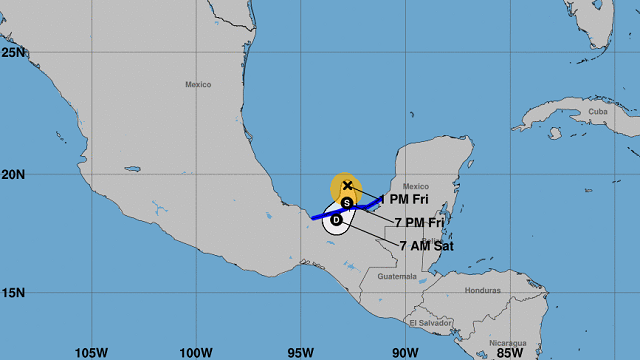
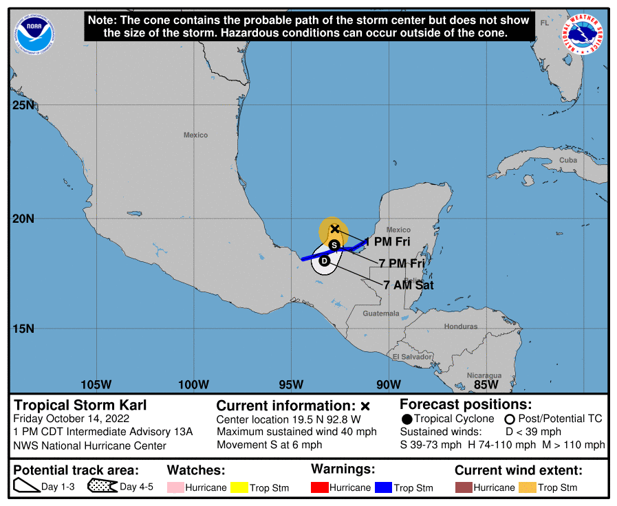
TROPICS: Tropical Storm Karl is a weak system in the far southwest Gulf of Mexico (the Bay of Campeche). Winds remain 40 mph, and landfall comes tonight on the southern coast of Mexico, far south of Texas.
 Showers and thunderstorms associated with a tropical wave several hundred miles southwest of the Cabo Verde Islands have decreased during the past several hours. Environmental conditions appear only marginally conducive for gradual development through the weekend while the wave moves generally westward at about 10 mph. Further development will become unlikely by early next week due to increasing upper-level winds.
The rest of the Atlantic basin is very quiet.
ON THIS DATE IN 1941: America’s first television weather forecast was broadcast on New York’s WNBT (later WNBC). There weren’t many televisions at that time, so viewers were limited to perhaps a few hundred people. The weathercast consisted of a sponsor’s message followed by a text screen containing the next day’s forecast.
ON THIS DATE IN 1984: Dense fog contributed to a 118-vehicle accident on I-94, just south of Milwaukee. At the time of the accident, the visibility was reportedly close to zero.
BEACH FORECAST: Click here to see the AlabamaWx Beach Forecast Center page.
For more weather news and information from James Spann and his team, visit AlabamaWx.


