James Spann: Strong to severe storms possible by Tuesday afternoon
SUNNY MONDAY AFTERNOON: Temperatures are generally between 75 and 80 degrees across Alabama this afternoon with a good supply of sunshine. Tonight will be mostly fair with a low around 60 degrees.
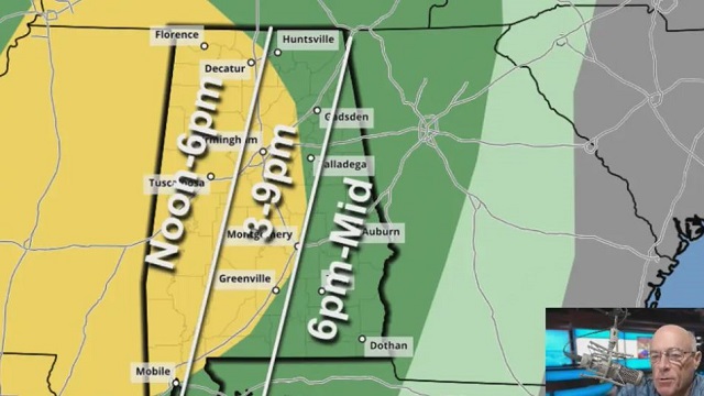
STORMY WEATHER RETURNS: A dynamic weather system will bring strong to possibly severe thunderstorms to Alabama Tuesday afternoon and night. The Storm Prediction Center maintains a slight risk (level 2 out of 5) of severe thunderstorms for areas west of a line from Huntsville to Talladega to Grove Hill. The rest of the state (the eastern and southern counties) are in a marginal risk (level 1).
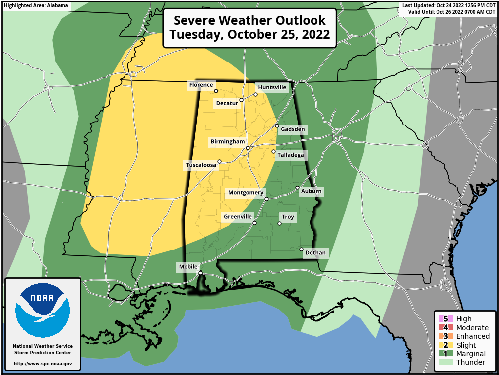 The main window for strong to severe thunderstorms is from around 1 until 10 p.m. Higher severe-weather probabilities are over the western half of the state; storms should weaken over east Alabama Tuesday night in a more stable air mass there.
Storms Tuesday afternoon and evening will be capable of producing large hail and strong winds. A few isolated tornadoes are possible over the western half of the state, in the level 2 risk area.
Rain amounts of around 1 inch are likely for west Alabama, with amounts of one-half to 1 inch for the eastern counties.
It has been a while since we have had a severe weather threat; be sure you can hear severe weather warnings if they are needed. A NOAA Weather Radio is the baseline and be sure Wireless Emergency Alerts are enabled on your phone. Install the free ABC 33/40 weather app.
Review your severe weather plan; know the safe place in your home, which is a small room on the lowest floor near the center of the house, away from windows. If you live in a mobile home be sure you know the location of the nearest shelter or site-built structure that is available, and the quickest way of getting there.
No need to be anxious; these setups are common in Alabama during our tornado season, which runs from November through May (this is a little pre-season action).
Dry weather returns to the state Wednesday and Thursday; the high will be in the upper 60s Wednesday, followed by mid 70s Thursday.
FRIDAY AND THE WEEKEND: The day Friday will be dry with a high in the 70s, but moisture will return late Friday night. The latest model guidance suggests the best chance of rain over the weekend will come Saturday night into Sunday. The weekend won’t be a total washout, but some rain from time to time is likely. There will be very little instability available, so there is no risk of severe storms, and we expect little thunder. Highs over the weekend will be between 65 and 70s for most communities.
NEXT WEEK: Showers could linger into Monday morning, but at this point it looks like the rain will be out of here by trick-or-treat time Monday night. New data suggests the next chance of rain will come Thursday; highs will be in the 70s through much of the week. TROPICS: The National Hurricane Center is monitoring a disturbance in the Atlantic about 100 miles east-southeast of Bermuda; it now has a well-defined center and is producing a relatively concentrated area of showers and thunderstorms. If the thunderstorm activity persists near the center, the disturbance will likely become a tropical depression later today or tonight while it moves west-northwestward and passes near Bermuda. After that time, the system is expected to turn northward and move toward cooler waters and into a region of unfavorable upper-level winds, which should limit additional development.
No systems will threaten the U.S. or the Gulf of Mexico this week.
ON THIS DATE IN 1878: The Gale of 1878 was an intense Category 2 hurricane that was active Oct. 18-25. It caused extensive damage from Cuba to New England. It is believed to be the strongest storm to hit the Washington-Baltimore region since hurricane records began in 1851.
ON THIS DATE IN 2005: Hurricane Wilma moved across the South Florida peninsula, causing $12 billion in damage. Hurricane-force winds affected all of southern Florida, with a damaging storm surge from Marco Island to Everglades City.
BEACH FORECAST: Click here to see the AlabamaWx Beach Forecast Center page.
For more weather news and information from James Spann and his team, visit AlabamaWx.


