Scott Martin: Arctic weather hangs around Alabama through the weekend
THE CHRISTMAS WEEKEND: While there will be plenty of sunshine across Alabama on Christmas Eve, conditions will be cold again. Lows will range from the single digits to the mid-teens, with nearly everyone in the area staying below freezing as highs top out only in the mid 20s to the lower 30s.
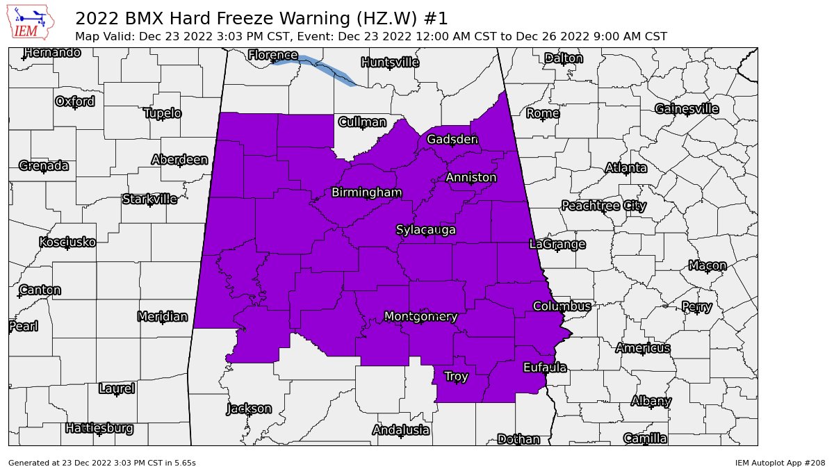
A wind chill warning continues until midday today for the Tennessee Valley counties, while a wind chill advisory continues for all of central Alabama until midday. A hard freeze warning continues for all of central Alabama until 9 a.m. Monday.
Christmas Day will be a little warmer as most locations finally make it above the freezing mark. However, early morning lows will start the day off in the teens. Afternoon highs will top out in the lower 30s to the lower 40s with sunny skies.
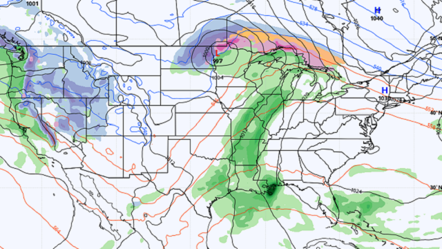
THE WORK WEEK AHEAD: A short wave will move across Kentucky, Tennessee and extreme northern Alabama on Monday that will bring the chance of some light snow to those states to our north. The southern end will be starved of moisture, and while a couple of flurries will be possible during the day, there will be no snow for central Alabama. Early mornings will be frigid, in the mid to upper teens, with afternoon highs in the 30s to the mid 40s.
A warming trend will start on Tuesday as we see ridging start to move in. Early-morning lows will be in the lower to mid 20s; highs reach the lower 40s to the lower 50s with sunny skies.
Humidity levels will begin to rise Wednesday as the flow will be coming from the south. Skies will be mostly sunny, and it will be warmer. Morning lows will be in the mid to upper 20s but will warm into the lower 50s to the lower 60s for the afternoon highs.
A short wave starts to organize to our west on Thursday, but models keep us dry at this point. A few clouds will begin to move in by afternoon, and I wouldn’t rule out a stray shower after midnight. The day will start off in the mid 30s to the mid 40s and top out in the upper 50s to the mid 60s by the afternoon.
On Friday, the short wave approaches and eventually moves into the state by the late afternoon. Rain chances will increase from the southwest and will be likely over the western half of Alabama by midnight. Morning lows will be in the 40s, with highs in the lower 60s to right around 70 degrees.
ON THIS DATE IN 1988: Early-morning thunderstorms developing along a cold front spawned a powerful tornado at Franklin, Tennessee, which killed one person, injured seven others and caused $8 million damage.
For more weather news and information from James Spann, Scott Martin and other members of the James Spann team, visit AlabamaWx.


