James Spann: Severe storms arrive in Alabama tonight
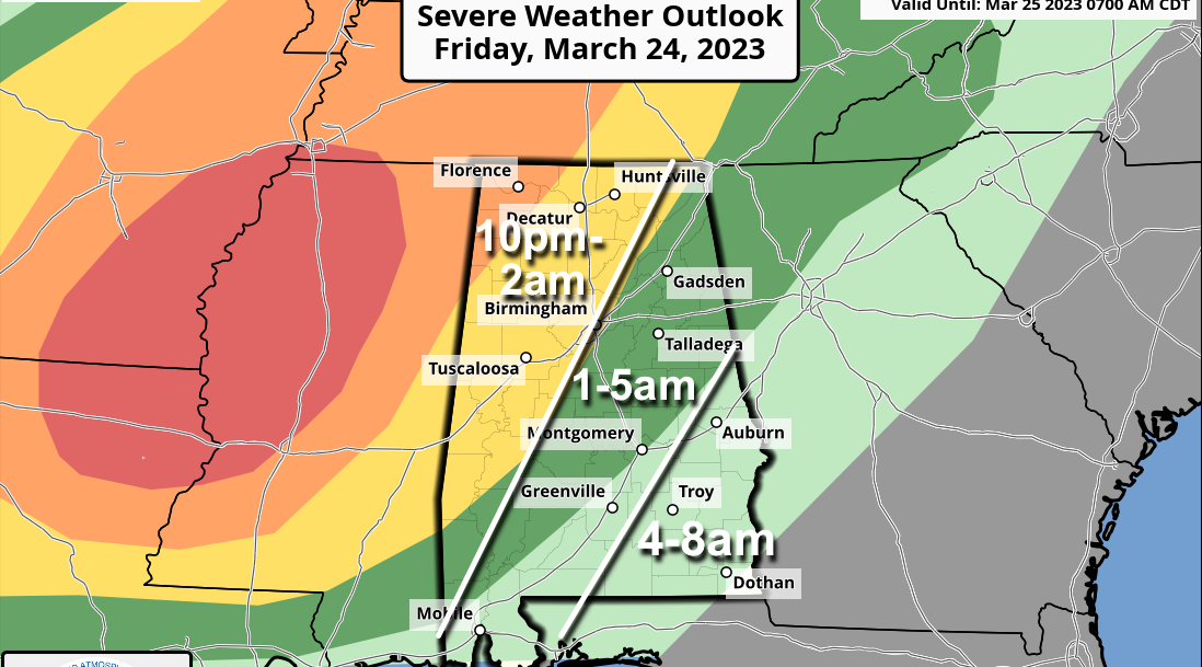
WARM, BREEZY AFTERNOON: Temperatures are close to 80 degrees across Alabama this afternoon with a mix of sun and clouds, and a gusty south wind. The weather gets active tonight as an organized band of showers and storms will push into the state ahead of a vigorous weather system. The Storm Prediction Center (SPC) maintains an enhanced risk (level 3 of 5) for the northwest corner of Alabama around the Shoals. A slight risk (level 2) extends down to Scottsboro, Birmingham and Sweetwater. A marginal risk (level 1) has been defined as far east and south as Alexander City, Montgomery and Jackson.
The higher tornado probabilities tonight are from Birmingham north and west, where the best combination of instability and shear will be found. Storms will also be capable of producing damaging winds and some hail. Gradient winds (not related to thunderstorms) could gust to 35 mph at times; a wind advisory is effect for much of north and west Alabama. Here are some notes concerning tonight’s weather:
- With events like this it is very important that you have a way of hearing weather warnings in the middle of the night. The baseline for every home and business is a NOAA Weather Radio. Those will wake you up.
- Be sure your phone has Wireless Emergency Alerts enabled, and “Do Not Disturb” and “Sleep Mode” are not active. Know the safe place in your home.
- Never, ever rely on an outdoor siren. Never.
- If you live in a mobile home, know the location of the nearest shelter (or business that is open 24/7 that can serve as a shelter), and the fastest way of getting there. Have transportation available. It sure isn’t convenient going to a shelter in the hours before dawn, but you can’t risk your life staying in a mobile home if you are in a tornado warning polygon.
- In your safe place, have helmets for everyone, not just children. Most serious injuries in tornadoes are related to blunt-force trauma above the shoulders.
- These type events are common here in March. Don’t get caught up in the TikTok/YouTube hyperbole. Just be prepared and we will get through the night together.
SATURDAY: The SPC maintains a marginal risk (level 1 out of 5) of severe thunderstorms for southeast Alabama Saturday morning for lingering showers and storms. The rest of the state will be dry and warm, with a partly sunny sky and a high at or just over 80 degrees.
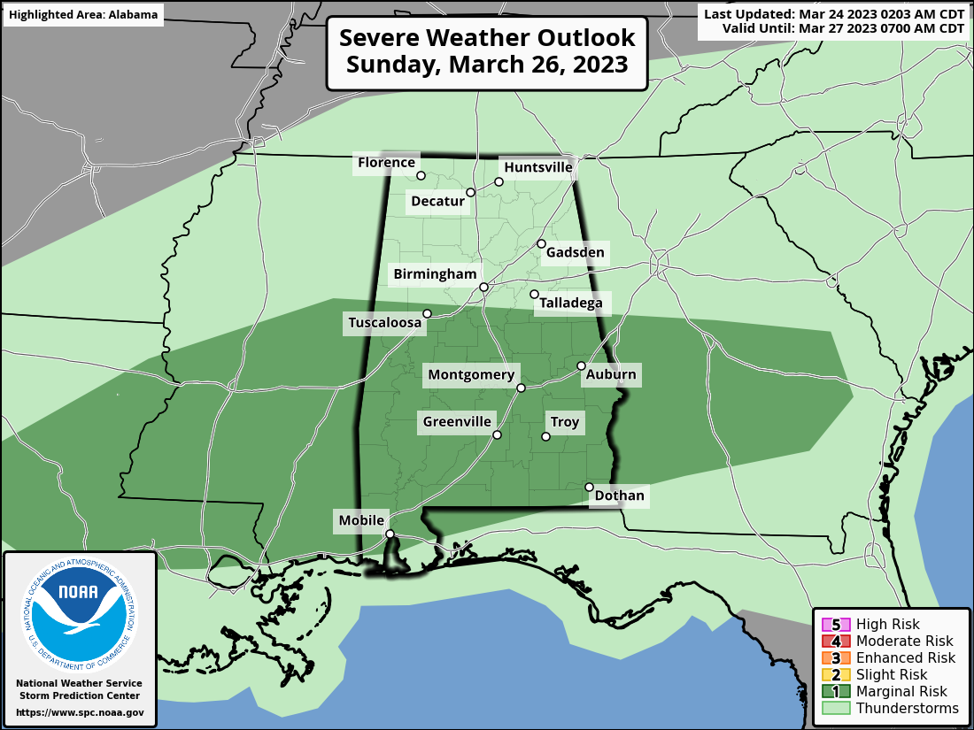
The front will stall out over south Alabama, drifting slowly northward Sunday. Showers and storms return, mainly over the southern two-thirds of the state (along and south of I-20). The air will be unstable and strong storms are possible Sunday afternoon, with the main threats coming from strong winds and hail; the SPC has defined a marginal risk (level 1). The high will be in the upper 70s.
NEXT WEEK: Showers and storms remain possible Monday and Tuesday, mainly over the southern two-thirds of the state. Dry, mild weather is expected Wednesday and Thursday before another round of showers and storms at the end of the week. Highs will be mostly in the 70s.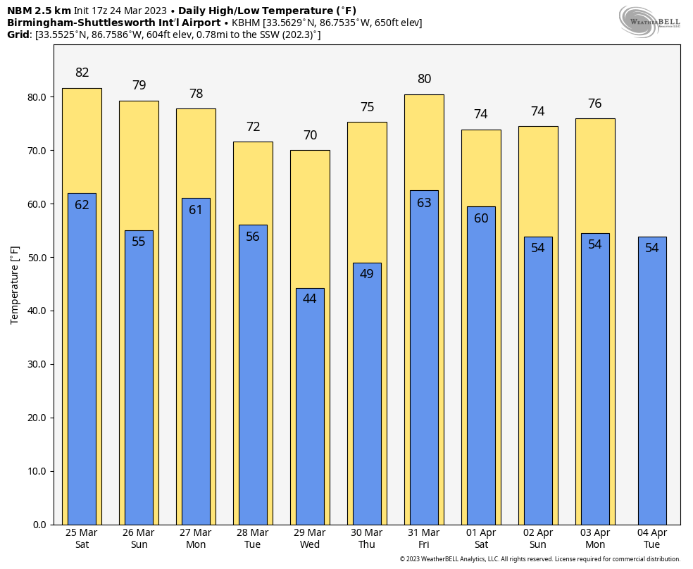 ON THIS DATE IN 1929: St. Louis, Missouri, soared to 92 degrees, its all-time record high for March.
ON THIS DATE IN 1975: “The Governor’s Tornado” hopscotched a 13-mile path across western Atlanta during the early morning, causing considerable damage to the Governor’s Mansion. Hundreds of expensive homes, businesses and apartment complexes were damaged. Total losses were estimated at $56 million. Three people lost their lives, and the F3 tornado injured another 152.
BEACH FORECAST: Click here to see the AlabamaWx Beach Forecast Center page.
For more weather news and information from James Spann and his team, visit AlabamaWx.


