James Spann: Big temperature contrast in Alabama today; showers form by afternoon
James Spann forecasts big range in temperatures for Alabama today from Alabama News Center on Vimeo.
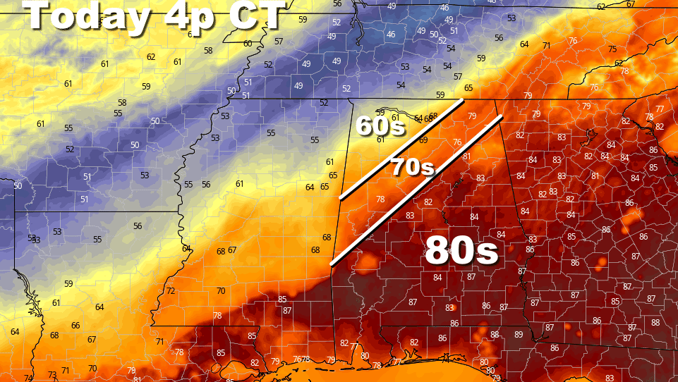
SLOW-MOVING FRONT: We will have a wide range of weather conditions across Alabama today thanks to a very slow-moving front near the northwest corner of the state early this morning. The most widespread rain today will be over the northwest counties near the front, but scattered showers and storms will form statewide this afternoon as the air becomes unstable with the daytime heating process. A flash flood watch is in effect for Franklin, Colbert, Lauderdale, Lawrence and Limestone counties, where heavy rain is possible. Rain amounts will be lighter and spotty over the rest of the state.
Some thunder is possible this afternoon, but there is no risk of severe thunderstorms. In fact, we see no risk of severe storms for at least the next seven days across Alabama and the Deep South — a welcome break.
Temperatures this afternoon will range from the low 60s around the Shoals to the low to mid 80s from Birmingham south and east.
FRIDAY AND THE WEEKEND: The front will sag slowly southward, and we expect occasional rain Friday and Saturday statewide. There will be some breaks in the rain along the way, but the chance of it raining at any one point each day will be 60-70%. Highs drop into the 60s over the northern third of the state Friday, with 70s for south Alabama. Many north Alabama communities won’t get out of the 50s Saturday, a good 15 degrees below average for mid-April.
Dry air returns Saturday night, and Easter looks very pleasant, with ample sunshine and highs between 65 and 75 degrees.
NEXT WEEK: The weather will be dry for the northern two-thirds of the state Monday through Wednesday; a few showers are possible near the coast. Global models suggest a chance of rain statewide by Wednesday night into Thursday, followed by dry air Friday. Highs through the week will be mostly in the 70s.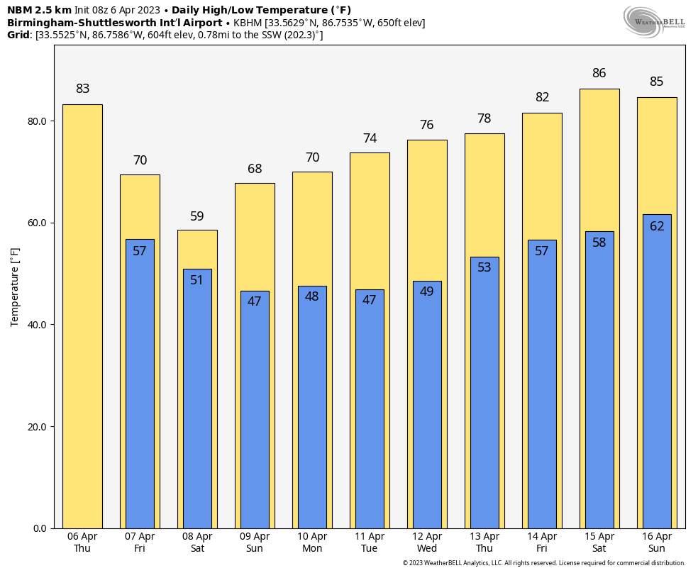 ON THIS DATE IN 1973: On April 6-8, a major spring snowstorm dumped 11.6 inches of snow across Denver. Most of the heavy, wet snow of 10.1 inches fell on April 7, when temperatures remained in the 20s. The low temperature of 5 degrees on April 8 was a new record low for the date and the lowest for so late in the season.
ON THIS DATE IN 2007: In Cleveland, Ohio, on April 6-9, the opening-season series between the Indians and Minnesota Twins was wiped out by a snowstorm and a cold snap. The Indians led 4-0 when umpires called off their April 6 home opener because of heavy snow. The grounds crew who tried to make the field playable with backpack blowers and brooms spent more time on the field than the players during nearly three hours of stoppages. About a foot of snow remained on the ground the afternoon of April 9.
BEACH FORECAST: Click here to see the AlabamaWx Beach Forecast Center page.
For more weather news and information from James Spann and his team, visit AlabamaWx.


