James Spann: Another dry day for most of Alabama; showers, storms return Thursday
James Spann has the Alabama forecast for midweek from Alabama News Center on Vimeo.
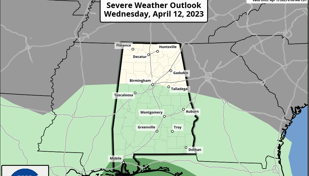
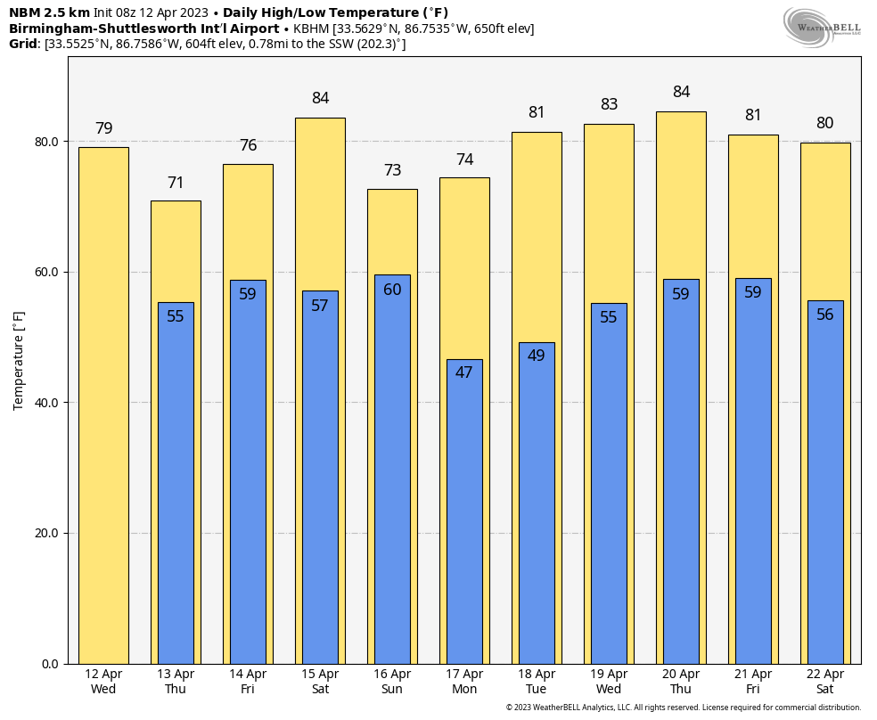
PLEASANT WEATHER CONTINUES: For most of Alabama this will be another spectacular spring day with ample sunshine and a high in the 70s. The exception will be near the Gulf Coast, where clouds will remain in place along with some risk of scattered showers and storms east of a broad surface low over south Louisiana. There is a marginal risk (level 1 out of 5) of severe storms along and south of I-10 this afternoon and early tonight; a few storms there could produce gusty winds. A brief waterspout or tornado can’t be ruled out.
THURSDAY/FRIDAY: The broad low will lift northward, along with moist air. Scattered showers and storms are possible statewide Thursday, and a few storms are possible during the afternoon and evening. The Storm Prediction Center has placed the southern three-quarters of the state in a low-end marginal risk (level 1) of severe thunderstorms.
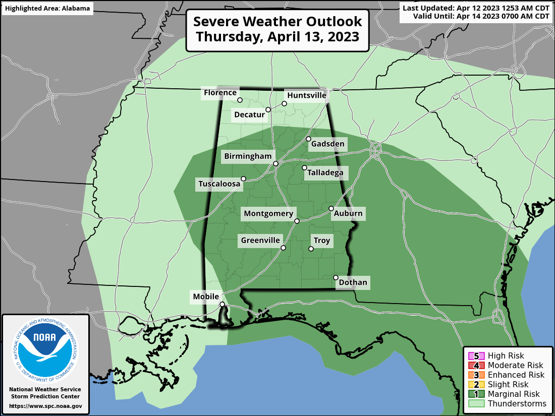
Buoyancy will be modest and wind dynamics not especially strong, but a few strong storms are possible during the peak of the daytime heating process, with potential for small hail and gusty winds. A brief, isolated tornado can’t be totally ruled out but isn’t likely. This won’t be an all-day rain, and highs will be between 68 and 76 degrees with a mostly cloudy sky.
A few lingering, scattered showers are possible Friday over the northern half of the state; otherwise, the day will be generally cloudy with a high in the 70s. A decent part of the day Friday will be dry.
THE ALABAMA WEEKEND: Saturday will be warm and dry. The sky will be partly to mostly sunny, and we expect afternoon temperatures to reach the low to mid 80s. A cold front will push a band of showers and thunderstorms into the state Saturday night into the hours before dawn Sunday. Initially storms could be strong as they push into the northwest corner of the state, with some potential for hail, but they should weaken quickly during the night and the overall severe weather threat for the rest of the state is very low.
Showers will end early Sunday (in most places by 8 a.m.) and the sky becomes partly sunny by afternoon with a high between 66 and 76 degrees.
NEXT WEEK: At this point the weather looks dry Monday through Wednesday with highs mostly in the 70s. Global models hint that moist air will return Thursday or Friday with some risk of showers on one or both days, but it is too early to be specific.
ON THIS DATE IN 1945: A series of significant tornadoes raked Oklahoma, Arkansas, Missouri and Illinois. Antlers, Oklahoma, was nearly obliterated by a massive F5 tornado that zigzagged from southwest to northeast across the town. Sixty-nine people died in the twister. Another tornado killed eight people in Oklahoma City.
ON THIS DATE IN 2020: A tornado outbreak was underway that lasted through April 13. Throughout the two-day outbreak, a total of 141 tornadoes touched down across 10 states, inflicting widespread and locally catastrophic damage. The outbreak ranks third for producing the most tornadoes in a 24-hour period, with 132 tornadoes; that tally is surpassed only by the 1974 Super Outbreak, with 148, and the 2011 Super Outbreak, with 219. The strongest tornado of the outbreak occurred in southern Mississippi and was given a high-end EF4 damage rating after producing estimated winds of 190 mph, reaching a width of 2.25 miles and causing eight deaths.
In Alabama, more than two dozen tornadoes touched down over the northern half of the state. This included a damaging rain-wrapped EF2 that struck a residential area at the southwestern outskirts of Boaz, injuring three people. Later, a high-end EF1 caused major damage and three injuries in Carbon Hill.
BEACH FORECAST: Click here to see the AlabamaWx Beach Forecast Center page.
For more news and information from James Spann and his team, visit AlabamaWx.


