James Spann: Strong storms over southeast Alabama; colder on Wednesday
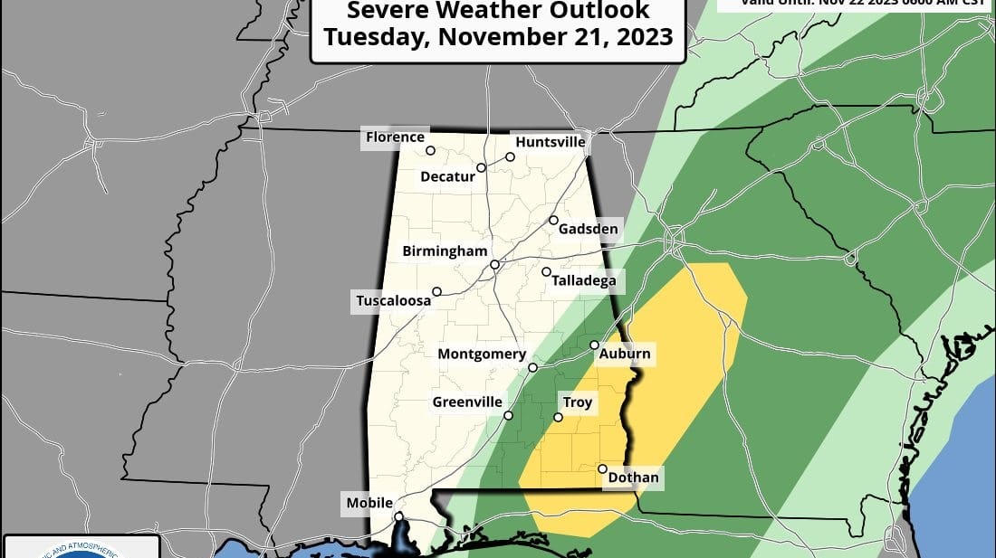
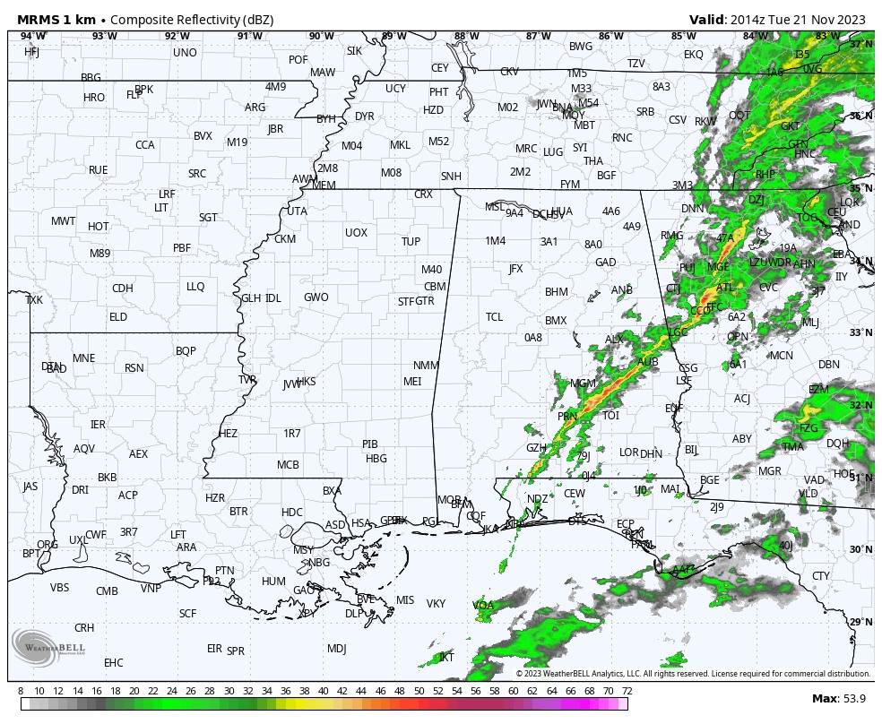
RADAR CHECK: A line of showers and thunderstorms is moving through southeast Alabama this afternoon. There is still a low-end severe weather threat with these storms; some of them could produce gusty winds as they pass through. A brief, isolated tornado can’t be ruled out but isn’t likely. Elsewhere, the sky is mostly cloudy over the northern two-thirds of the state with some sun peeking through at times. Temperatures are in the 60s and low 70s.
Storms clear the southeast corner of the state this evening, and tonight will be mostly cloudy and colder, with a low in the 40s.
WEDNESDAY/THURSDAY: An upper low will swing through north Alabama early Wednesday with clouds and perhaps a sprinkle or two, but nothing meaningful. The sky becomes mostly sunny Wednesday afternoon with a high between 55 and 65 degrees. For Thanksgiving Day, the sky will be partly to mostly sunny with highs in the 50s over the northern counties of the state and low to mid 60s for south Alabama. The low Thursday morning will be in the 30s for most communities.
FRIDAY AND THE WEEKEND: A weak low in the northern Gulf could bring some scattered light rain to the southern two-thirds of Alabama Thursday night into Friday morning, but with limited moisture rain amounts will be very light and spotty; many places won’t see a drop. The sky will be mostly cloudy Friday with highs around 60 degrees.
Then, expect a cool, dry weekend with a partly sunny sky both days. Highs will be between 58 and 63 degrees, with lows mostly in the upper 30s and low 40s.
NEXT WEEK: For now, the first half of the week looks dry; some rain could move into the state by Thursday and Friday with another low passing through the northern Gulf of Mexico.
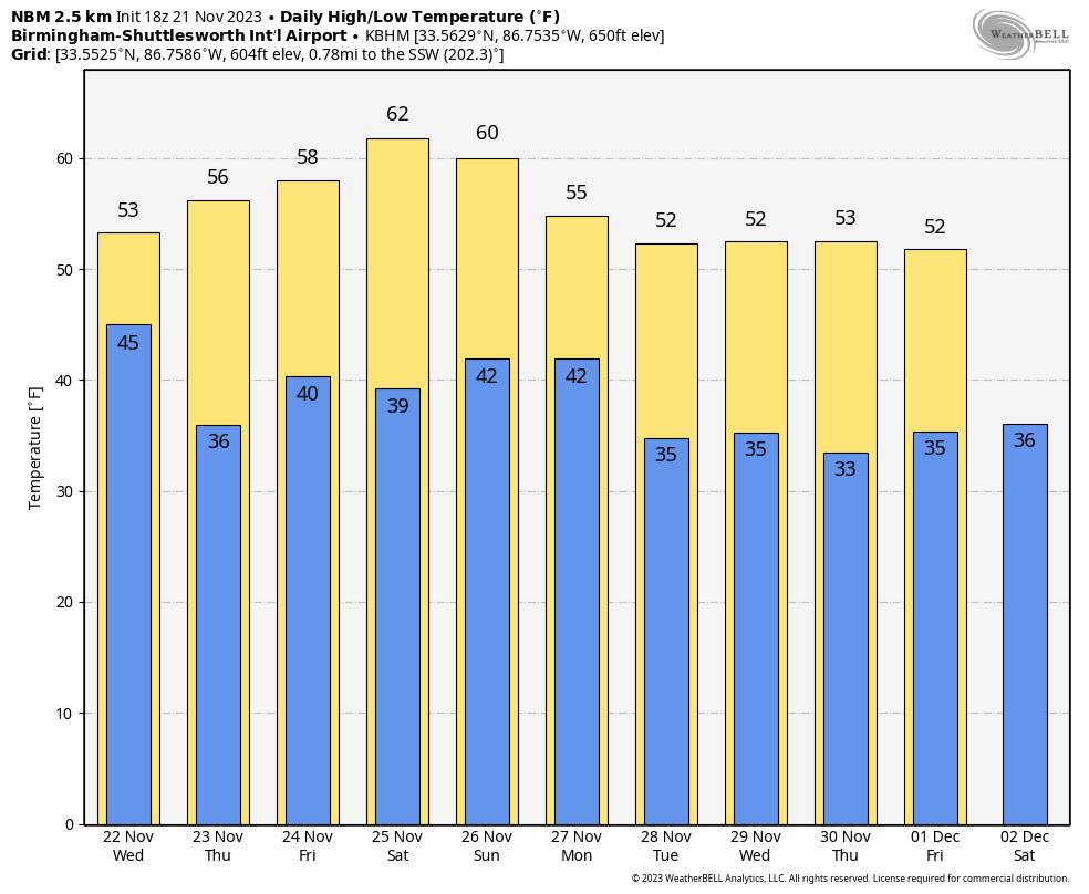
IRON BOWL: The weather looks delightful for Saturday’s Iron Bowl (Alabama at Auburn, 2:30 p.m. kickoff). The sky will be partly sunny with temperatures falling from near 62 degrees at kickoff into the 50s by the fourth quarter. There will be no risk of rain.
TROPICS: The National Hurricane Center is monitoring a disturbance in the Caribbean; it has only a 10% chance of development over the next seven days as it drifts westward. An area of low pressure is expected to develop along a frontal boundary over the central subtropical Atlantic later today or tonight. This nontropical low is forecast to move southeastward over warmer sea-surface temperatures during the next few days, and environmental conditions appear conducive for this system to gradually acquire tropical characteristics. A subtropical or tropical storm could form by the latter part of this week as the system continues moving eastward, followed by a turn northeastward by the weekend.
This feature has a 60% chance of development over the next seven days, but it will remain far from land. Hurricane season ends in nine days.
ON THIS DATE IN 1992: The Nov. 21-23 tornado outbreak was the third-largest outbreak in recorded history and one of the longest continuous outbreaks ever recorded. There was no break in tornado activity from 1:30 p.m. on Nov. 21, when the tornadoes started in Texas, until 7:30 a.m. on Nov. 23, when the last tornadoes lifted in North Carolina. On this date, severe thunderstorms spawned six tornadoes within 70 minutes in the Houston metro area in Texas. At one time, there were three on the ground in Harris County. The strongest, an F4, tracked 20 miles through the eastern suburbs of Houston, destroying 200 homes and damaging 1,000 more. In total, 23 tornadoes struck Mississippi and Alabama. The deadliest tornado of 1992, an F4, killed 12 people on a 128-mile track through seven Mississippi counties. One of the bodies was blown a quarter mile into a tree.
Alabama had 13 tornadoes touch down ranging in strength from F0 to F2, with no deaths and 53 injuries. The tornado with the most injuries occurred just outside Sardis City, where multiple structures were damaged and 12 people were injured.
For more weather news and information from James Spann and his team, visit AlabamaWx.


