Bill Murray: Some Christmas rain lingers for Alabama, with colder weather ahead
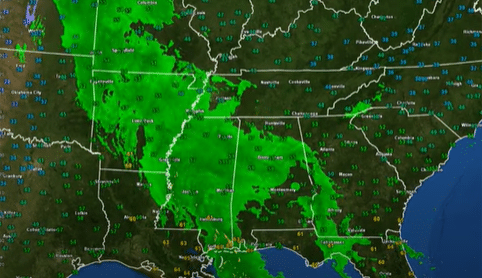
CHRISTMAS DAY: Rain moved into Alabama overnight. On the backside of that rain, we find a thin line of heavier rain and some lightning, the result of a little mesoscale convective vortex that is pushing northeastward. This activity should push through Birmingham by 8 a.m., and most of it should be east of I-65 by noon. We may not get the last showers out of Alabama and into Georgia until 6 p.m. Highs this afternoon will be in the 60s across all of north and central Alabama. Lows tonight will flirt with the 30s over northwest Alabama, with 40s for areas along and west of I-65 and lower 50s to the east.
WINDY: Winds picked up overnight as the surface lows intensified and have been gusting to more than 25 mph and occasionally approaching 40 mph. I hope you secured all those inflatable Christmas figures on your lawn. The winds will remain gusty until mid-afternoon.
THE SLOW WEEK: An upper low will take it slow, moving from Nebraska through the Midwest and into the Tennessee Valley between now and Thursday. The main change in Alabama’s weather will be a trend to colder. Tuesday’s and Wednesday’s highs will be in the middle and upper 50s. By Thursday, a secondary wave of colder air will drop readings back into the 40s. Only areas as far south as Montgomery will be able to reach 50 degrees both Thursday and Friday. Lows will be in the upper 30s and lower 40s all week.
CLOUDS: There could be a few peeks of sun this afternoon, but don’t count on it. Tuesday will be mostly cloudy, with the best chance of seeing the sun over the northwest corner of the state. Areas northwest of I-59 should see lots of sunshine Wednesday, with clouds hanging tough to the southeast. Thursday looks cloudy as well, as moisture works its way back in from the northwest. That upper low could trigger a little light rain or light snow across the Tennessee Valley, with just light rain as far south as I-20. It looks like the sun will return in time for Friday and the New Year’s weekend.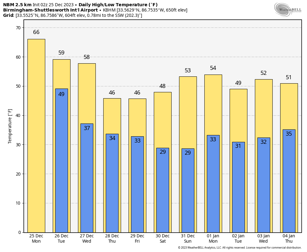
WEEKEND OUTLOOK: Saturday looks sunny and chilly, with highs in the 40s and lower 50s. Sunday will be about the same but with temperature readings about 5 degrees warmer. Morning lows will be in the upper 20s.
Sunday evening celebrations will feature dry, cool conditions, with lows in the lower and middle 30s. By the time you’re eating your black-eyed peas and greens, a few light showers may be popping up.
BOWL WEATHER: Weather looks dry and cool for the Music City Bowl in Nashville on Saturday, with Auburn taking on Maryland. Gameday highs will be in the 40s with lows in the upper 20s. Bama fans heading west will find warmer conditions for the Rose Bowl. Gameday highs will be in the middle 60s, with lows in the middle 40s.
VOODOO TERRITORY: Rain or snow for Thursday, Jan. 4? It’s still a long way off, but certainly something to watch.
ON THIS DATE IN 1989: Northeast Florida had a White Christmas, its first ever. A major cold wave affected all 67 counties of the Sunshine State with record-low temperatures. Temperatures plunged to 22 degrees in Orlando, with readings in the teens recorded in some of the normally colder locations. Citrus crops sustained major damage. Two to 3 inches of snow fell in the Florida Panhandle. Tallahassee had a trace of snow. Traffic accidents on icy roads resulted in fatalities. Airports and interstates were closed. Snow and sleet fell as far south as Sarasota and Melbourne.
For more weather news and information from James Spann, Bill Murray and other members of the James Spann team, visit AlabamaWx.


