Scott Martin: Mainly dry and definitely hot weekend for Alabama, with a few showers possible
THIS WEEKEND: Ridging over Alabama will create weak winds and hot conditions today, with temperatures reaching the mid to upper 90s. Southeasterly winds will increase moisture levels in our extreme southeastern counties, possibly leading to isolated showers and storms in the afternoon and evening south of I-85.
The ridge will shift westward on Sunday, allowing a trough to develop over the eastern U.S. This change will bring continental northwesterly winds at high altitudes and westerly winds at lower levels, making Sunday even hotter, with highs in the mid to upper 90s. I wouldn’t be surprised if a couple of locations hit 100 degrees. The rain chances will remain low on Sunday, but hot conditions will persist into the beginning of the work week as moisture continues to increase.
MONDAY THROUGH FRIDAY: Increasing humidity will make it muggy to start the work week. On Monday, it will be very hot and humid, with only a small chance of isolated to scattered showers and storms during the morning. Highs will be in the mid 90s under partly sunny skies.
Tuesday will be another very hot day, with partly to mostly sunny skies and a low chance of isolated to scattered afternoon showers and storms. Highs will be in the mid 90s to the lower 100s.
By Wednesday, a significant change in our weather pattern will happen. An increase in moisture levels combined with increasing instability will lead to widespread convection. This means you can expect more frequent showers and thunderstorms, especially during the afternoon and evening. The good news is that these storms will help reduce temperatures. Highs will be in the lower to mid 90s.
The weather will stay somewhat active on Thursday, with scattered showers and storms possible at times. While humidity will continue to be high, afternoon highs will be a little cooler, in the upper 80s to the lower 90s.
We go back to a more typical summer forecast on Friday. We’ll have partly to mostly sunny skies, with a very small chance of an isolated shower or two. Unfortunately, it will be hotter, with highs in the lower to mid 90s.
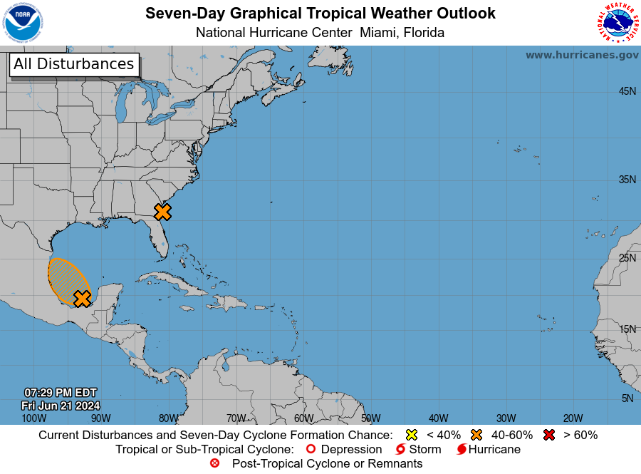
TROPICS: Over the southwestern Atlantic Ocean, there’s a well-defined low-pressure area about 40 miles southeast of Brunswick, Georgia. Right now, it’s only producing minimal showers and thunderstorms. This area is expected to move inland in the next few hours, and the chances of it becoming a tropical depression are decreasing. The chance of formation through the next seven days is 40%.
Over the southwestern Gulf of Mexico, a broad area of low pressure is forming over the Bay of Campeche. The environment looks good for gradual development as it moves slowly west-northwestward or northwestward. A tropical depression could form over the southwestern Gulf of Mexico this weekend.
ON THIS DATE IN 1947: A significant tornado outbreak affected parts of the Midwest, especially Ohio and Pennsylvania. The most devastating tornado was an F4 that struck Erie, Pennsylvania, causing extensive destruction, killing 20 people and injuring more than 300. The outbreak included multiple tornadoes and severe thunderstorms, resulting in widespread damage and highlighting the severe weather risks even outside the traditional tornado season.
For more weather news and information from James Spann, Scott Martin and other members of the James Spann team, visit AlabamaWx.


