James Spann: Highs hold in the 90s; mostly dry Tuesday for Alabama
James Spann forecasts a dry Tuesday for most of Alabama from Alabama News Center on Vimeo.
PLEASANT START: We are seeing some spots in the low to mid 60s across north Alabama early this morning for a nice, brief touch of fall. But temperatures rise quickly, and we expect highs in the mid 90s in most places again today. Any showers or storms will be confined to the southern third of the state, and even there most places will stay dry.
Moisture levels rise Wednesday, and we will mention the chance of an afternoon shower or thunderstorm in scattered spots. The high will be between 93 and 97 degrees.
THURSDAY THROUGH THE WEEKEND: We expect classic summer weather on these four days — hot and humid with a partly sunny sky and random, scattered showers and thunderstorms mostly during the afternoon and evening. The chance of any one spot getting wet each afternoon is 30-40% Thursday and 50-60% Friday through Sunday. You might get 1 inch of rain while your neighbor gets nothing. Highs will be in the low to mid 90s.
The summer pattern persists next week. Expect hot, muggy days with the daily chance of a pop-up shower or thunderstorm, mostly between 1 and 10 p.m.
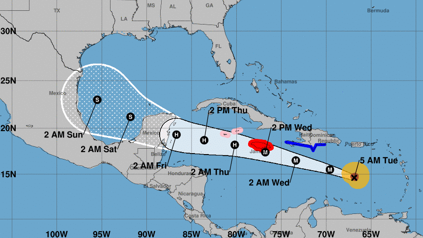
TROPICS: Beryl is a powerful Category 5 hurricane in the Caribbean this morning with sustained winds of 165 mph. It will be near Jamaica Wednesday, where a hurricane warning is in effect. Beryl should slowly weaken over the next few days. Factors such as the possible interaction with the Jamaican elevated terrain, dry air intrusions and the structure of the vertical wind shear will all play a role in the rate of weakening. The models show quite a wide range of solutions, with guidance between a strong tropical storm to a major hurricane while it nears the Yucatan Peninsula. The National Hurricane Center forecast lies in the middle, showing Beryl as a major hurricane near Jamaica, reaching Yucatan as a hurricane in about 72 hours before emerging as a tropical storm over the Gulf of Mexico. This is quite an uncertain forecast beyond a couple of days.
There is a chance a northward component of motion begins over the southwest Gulf of Mexico; models show final landfall anywhere from Mexico to Louisiana. Most global models suggest Beryl at that time will be a tropical storm, not the intense hurricane we see today. But there is much uncertainty in what happens in the three- to seven-day time frame. Odds are still high that there will be little to no direct weather impact on the central Gulf Coast (Gulf Shores to Panama City Beach).
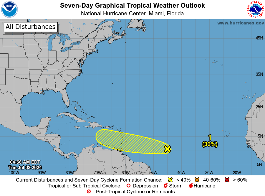
Another tropical wave is trailing Beryl in the Atlantic. The chance of development with this system has dropped to 30%; it remains just something to watch for now.
ON THIS DATE IN 1843: An alligator reportedly fell from the sky onto Anson Street in Charleston, South Carolina, during a thunderstorm.
ON THIS DATE IN 2001: In Michigan, frost and freezing temperatures were observed in some locations, with Grant dropping to 29 degrees. Muskegon reported its coldest July temperature on record at 39 degrees.
For more weather news and information from James Spann and his team, visit AlabamaWx.


