James Spann: Beneficial rain ahead for the southern half of Alabama
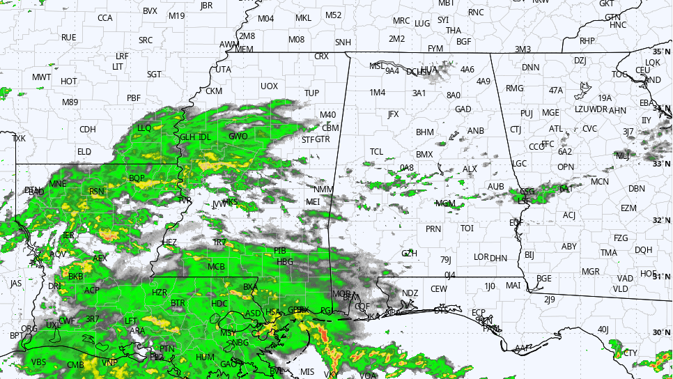
RADAR CHECK: Areas of light rain continue over the southern half of Alabama this afternoon near a stalled surface front near the Gulf Coast. Most of the state has a cloudy sky, but the sun is out over the Tennessee Valley with temperatures in the 80s.
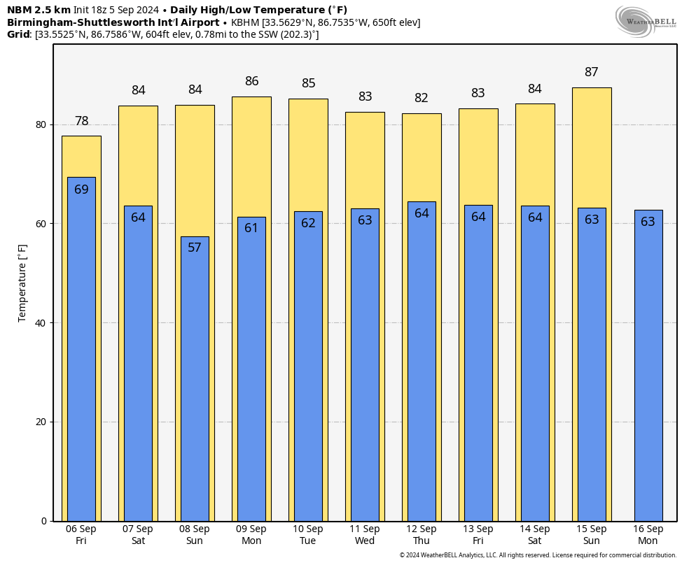
We expect periods of rain through Friday night as a weak surface low moves along the stalled front. The most widespread and beneficial rain will be over the southern half of the state, where amounts of 1-2 inches are likely. Amounts over the northern third will be light and spotty, unfortunately. Temperatures won’t get out of the 70s Friday because of clouds, rain and a cool easterly low-level flow.
THE ALABAMA WEEKEND: We will mention just a few isolated showers Saturday as a surface front passes through the state; the deeper moisture will be gone by then, so many places will be dry with a mix of sun and clouds. Saturday’s high will be in the mid 80s for most places. On Sunday, a dry air mass will cover most of the state; any showers will be confined to the far southeast corner. We start the day in the 50s, followed by a high in the 80s.
NEXT WEEK: Much of next week will be dry with highs mostly in the 80s and lows between 60 and 65 degrees. Cooler spots over north Alabama will drop into the 50s again early in the week. There will be some risk of widely scattered showers across far south Alabama Monday through Wednesday, but amounts will be light.
 FOOTBALL WEATHER: For high school games across the state Friday night, some rain is possible, if not likely, over the southern two-thirds of the state. We’re not expecting any lightning, however, and temperatures will be in the 70s.
On Saturday, Auburn will host California at Jordan-Hare Stadium (2:30 p.m. kickoff). The sky will be partly sunny, and a brief shower can’t be ruled out. Temperatures will hover in the low to mid 80s during the game.
Alabama will host South Florida Saturday in Tuscaloosa (6 p.m. kickoff). The sky will be mostly clear with temperatures falling from the low 80s at kickoff into the upper 60s by the final whistle.
UAB will be on the road, taking on Louisiana-Monroe Saturday (6 p.m. kickoff). The sky will be clear with about 83 degrees at kickoff; temperatures drop to near 70 degrees by the fourth quarter.
TROPICS: While the National Hurricane Center (NHC) is monitoring five areas across the Atlantic basin, they all have only a low chance of development. The two we are watching:
- A large area of showers and thunderstorms continue in association with a broad area of low pressure interacting with a weak frontal boundary over the northwestern Gulf of Mexico. Upper-level winds are expected to become less conducive for development by late Friday and Saturday as another frontal boundary approaches the system. Although development is unlikely, heavy rainfall is expected across portions of the western and central Gulf Coast during the next day or so. The NHC gives this system only a 10% chance of development.
- Shower and thunderstorm activity remains disorganized in association with a westward-moving tropical wave over the western Caribbean Sea. Development is not expected before the system reaches Belize and the Yucatan Peninsula by early Friday. Some gradual development is possible late in the weekend into early next week after the system emerges over the southwestern Gulf of Mexico. The chance of development has dropped to 20%.
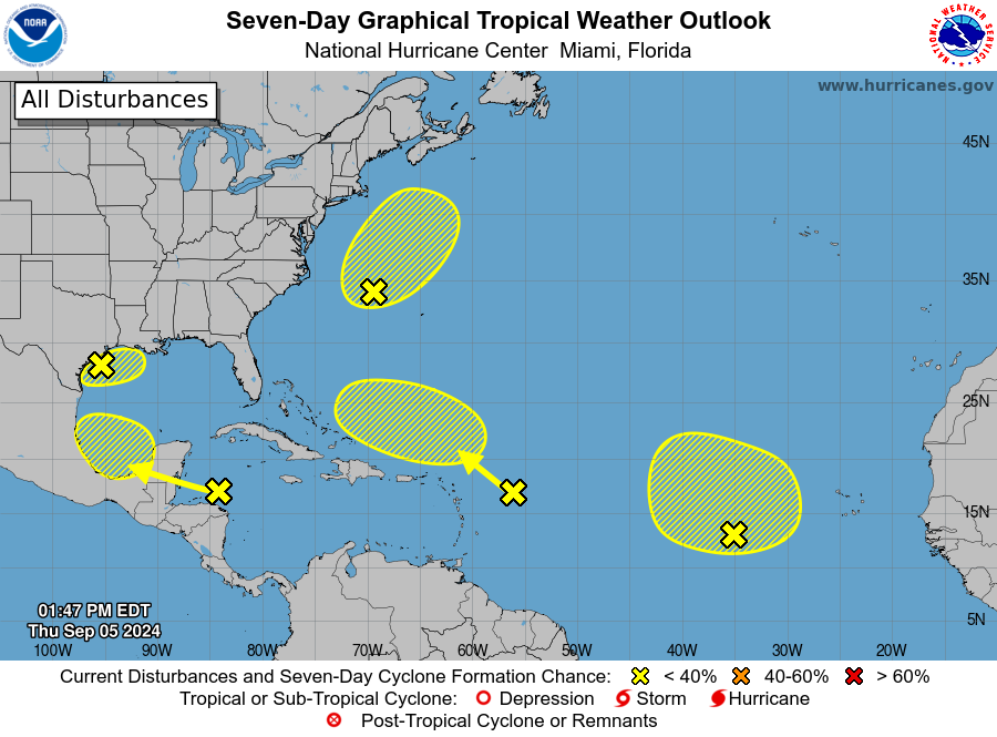 Bottom line: Despite the five areas of interest, the tropics remain remarkably quiet for September.
ON THIS DATE IN 1925: The temperature soared to 112 degrees at Centreville, the hottest temperature on record in Alabama. This was part of a brutal 1925 heat wave that cranked up in July, got meaner in August and peaked in September. There was no air conditioning, and human suffering was extreme. This was a true example of a heat emergency.
ON THIS DATE IN 1950: Hurricane Easy was an erratic and unpredictable hurricane that lingered over the Tampa Bay area for days, dropping torrential rains and causing damage especially in Cedar Key, Florida, where the storm eventually made landfall. This hurricane dumped 38.7 inches of rain in 24 hours in Yankeetown, a record for the U.S. at the time, and caused $3.3 million in damage. Total rainfall in Yankeetown was 45.2 inches.
ON THIS DATE IN 1996: Hurricane Fran made landfall near the tip of Cape Fear, North Carolina, with maximum sustained winds near 115 mph. Fran was responsible for 26 deaths and was at the time the most expensive natural disaster ever in North Carolina’s history.
For more weather news and information from James Spann and his team, visit AlabamaWx.


