Scott Martin: Mainly dry Saturday for Alabama; long stretch with showers possible starts Sunday
MAINLY DRY, MILD SATURDAY: I believe we can actually squeeze off a nice, dry day across Alabama for your Saturday. Much of the shower activity will be up in Tennessee, as we’ll have a ridge set up that will force those showers northward. There is a very tiny chance of a stray shower for northern Alabama, but those look unlikely at this point. We’ll have partly to mostly cloudy skies with highs reaching the lower 70s to the lower 80s.
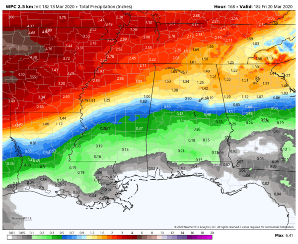
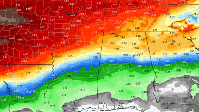
MANAGEABLE RAINFALL: Rainfall totals from today through midday Friday will be manageable, ranging from less than one-quarter inch in the southeast to as high as just over 1.5 inches in the northwest. So, no flooding is expected through this forecast period.
SHOWERS POSSIBLE SUNDAY: Skies will be mainly cloudy throughout the day Sunday and we’ll have showers possible at any time, but the higher chances will remain over the northern half of the state and during the morning. Cooler air will move into Alabama with a cold front. Highs across the state will range from the lower 60s in the northwest to the lower 80s in the southeast.
RAIN CHANCES FOR EVERY DAY OF THE WORK WEEK: Monday will start off dry, but showers look to creep in from the west during the afternoon. A few claps of thunder are possible, but that will be no big deal as strong to severe storms do not look likely. Highs will be in the upper 60s to the upper 70s.
Much of the morning looks dry on Tuesday, but showers move back in during the afternoon and evening. Again, a few claps of thunder are possible, but no severe weather is expected. Highs top out in the upper 60s to the mid-70s.
Expect almost the same story for Wednesday — mainly dry early with showers and a few embedded thunderstorms moving in during the afternoon and evening. Higher chances will remain over the northern half of the state. Highs range from the lower 70s in the northwest to around 80 degrees for the southeast.
Much of the shower activity moves out by daybreak Thursday, but a few lingering light showers will be possible during the remainder of the day. Highs will top out in the mid-70s to the lower 80s.
A surface low will move through the Midwest and up into the Great Lakes Region during the day Friday, pushing a cold front in our direction. Showers will become possible along and north of the I-59 corridor by midday but will eventually move southward during the late night and overnight. Highs will be in the mid-70s to the lower 80s.
BEACH FORECAST: Get the latest weather and rip current forecasts for the beaches from Bay St. Louis, Mississippi, to Panama City Beach, Florida, on our Beach Forecast Center page. There, you can select the forecast of the region you are interested in.
For more weather news and information from James Spann, Scott Martin and other members of the James Spann team, visit AlabamaWx.com.


