James Spann: Scattered storms for Alabama this evening, with large hail possible
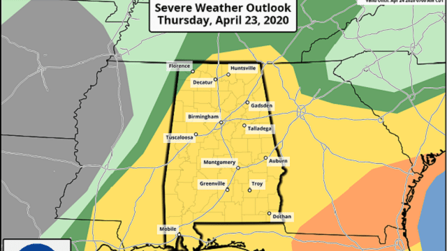
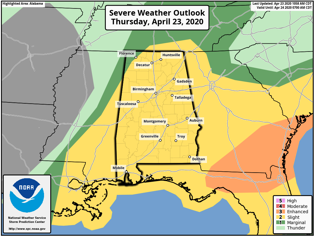
SCATTERED STORMS INCREASING: Thunderstorms are increasing through parts of central Alabama this afternoon; one storm has moved through parts of Sumter, Greene and Hale counties in west Alabama, producing large hail. Other storms that form will also be capable of large hail as they move northeast. The good news is that wind profiles do not support tornado activity over Alabama now. The Storm Prediction Center maintains a slight risk (level 2 out of 5) of severe thunderstorms for most of the state.
Storms will end from west to east early tonight as dry air moves into the state.
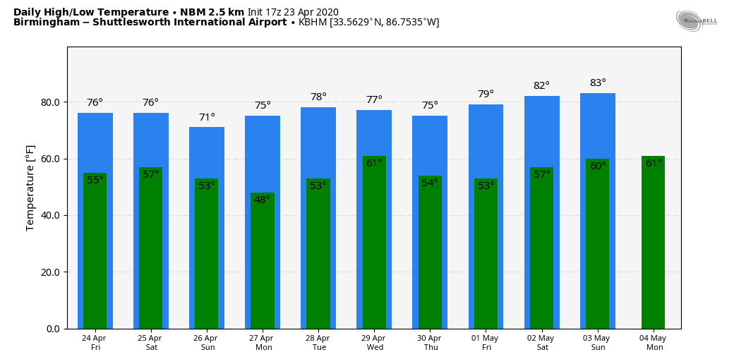
FRIDAY THROUGH THE WEEKEND: Friday will be a dry day with a partly to mostly sunny sky and a high in the mid 70s. Then, a fast-moving weather system will bring a few showers, and possibly a thunderstorm, to the northern third of the state late Friday night into early Saturday morning. It looks like the air will be stable, and odds of any severe weather look low. The sky becomes partly sunny Saturday afternoon with a high in the 72- to 75-degree range. And finally we’ll have a Sunday with no severe weather worries; the sky will feature a good supply of sunshine with a high in the low 70s.
NEXT WEEK: Monday and Tuesday look dry with a high in the 70s. The next weather system will bring periods of rain and possibly a thunderstorm to the state Tuesday night into Wednesday, but for now we are not expecting severe weather. Dry air returns for Thursday and Friday.
MORNING STORMS: Round one of rain and thunderstorms over Alabama this morning produced wind damage in parts of Tuscaloosa, Hale and Perry counties. A gravity wave/wake low on the back edge of the rain mass was responsible for knocking down hundreds of trees over the eastern half of the state. Winds were generally in the 40-45 mph range, but the saturated soil conditions helped the trees come down easily. Thankfully we have heard of no injuries.
ON THIS DATE IN 1999: A horrific hailstorm moved southeast from Pennsylvania across Garrett County, Maryland, and into the eastern panhandle of West Virginia. By the time it reached Capon Bridge in eastern Hampshire County, West Virginia, the size of the hail had grown from golf balls to baseballs. As it moved into Frederick County, Virginia, the hail storm continued to grow in a swath from north of Winchester south to Stephen City, about 10 miles. Hailstones grew to the size of grapefruit east of Winchester.
WEATHER BRAINS: You can listen to our weekly 90-minute show anytime on your favorite podcast app. This is the show all about weather featuring many familiar voices, including the meteorologists at ABC 33/40.
CONNECT: You can find me on the major social networks:
Facebook
Twitter
Instagram
Pinterest
Snapchat: spannwx
For more weather news and information from James Spann and his team, visit AlabamaWx.


