James Spann: Alabama quiet for now; another hurricane develops in the Gulf this week
James Spann forecasts a quiet beginning, rainy end to the Alabama work week from Alabama NewsCenter on Vimeo.
EYES ON THE TROPICS: Alabama’s weather will remain quiet through Wednesday, but our attention will be focused on tropical developments that will bring big changes late this week. We are seeing mostly 50s across the state early this morning; the high today will be in the upper 70s with a sunny sky. The average high for Birmingham on Oct. 5 is 79.
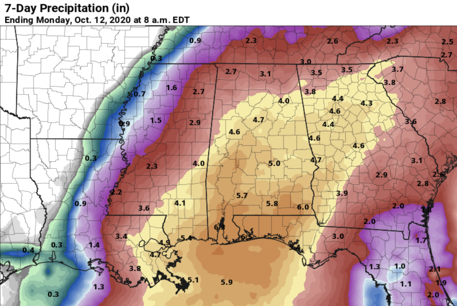
Tuesday and Wednesday will be warm and dry with a mostly sunny sky both days; the high will be in the low 80s Tuesday, followed by mid 80s Wednesday. Clouds will increase Thursday; rain is likely over south Alabama during the day, and then statewide Thursday night and Friday as Hurricane Delta moves into the Louisiana coast. Rain then should end across the state from southwest to northeast during the day Saturday as the remnant circulation moves away from the state.
Rain amounts of 3-5 inches look likely for much of Alabama; for now major flash flooding is not expected since the ground is not saturated, and the rain should be fairly steady and moderate in nature.
For now the tornado threat looks low since the air will be relatively stable across Alabama. But keep in mind all of this could change when the system develops and we get better upper-air data from hurricane hunters.
For now Sunday looks fairly quiet with a mix of sun and clouds and only isolated showers. Highs over the weekend will be in the 70s.

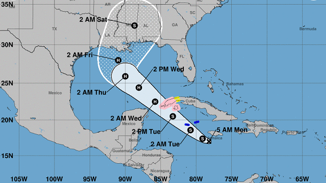
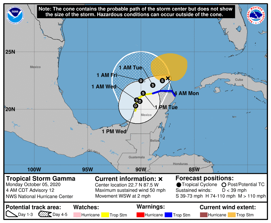
GAMMA: Tropical Storm Gamma is a highly sheared system near the northern tip of the Yucatan Peninsula; it won’t move much this week.
DELTA: Tropical Depression 26 is expected to become Tropical Storm Delta later today. Models are in good agreement, and the latest National Hurricane Center track brings the system to hurricane strength Tuesday night near the Yucatan channel. From there, it moves into the Gulf of Mexico and is forecast to make landfall on the Louisiana coast between Morgan City and Grand Isle late Thursday night or early Friday morning. The remnant circulation will move up through Mississippi and Alabama Friday and Saturday.
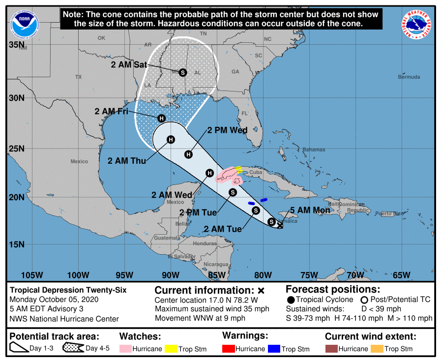
It is important to note that the average four- and five-day NHC track forecast errors are about 160 to 200 miles at those time periods, respectively. Meaning, of course, this forecast can change. If you are working with old information when it comes to a hurricane forecast, you are working with bad information.
Concerning the intensity forecast, the NHC expects peak intensity Wednesday night into Thursday morning, followed by weakening due to likely cold upwelling of shallow, cool shelf waters off the southwest coast of Louisiana and Mississippi. Delta most likely will be a Category 1 or 2 hurricane at the time of landfall, but, again, this could change.
COASTAL IMPACT: It is a little early for specific impact forecasts for any given point along the Gulf Coast. But rain becomes likely along the Alabama and northwest Florida coasts Thursday, with breezy, wet conditions continuing Friday and Friday night. The rain should end along the coast during the day Saturday, and for now Sunday looks mostly dry with only isolated showers.
A few isolated, brief waterspouts or tornadoes will be possible near the coast Thursday night and Friday, and rain amounts of 4-6 inches are likely from Thursday through Saturday morning.
For now the highest risk of wind and storm surge damage seems to be across southeast Louisiana and coastal Mississippi, but, again, this could change. We will be much more specific on the coastal impact tonight and Tuesday.
ON THIS DATE IN 1972: Tropical Storm Joanne, earlier a hurricane, moved across the Baja California peninsula and came ashore in western Mexico south of Ajo. The storm brought heavy rain and flooding to much of Arizona. This storm is the first documented tropical storm to reach Arizona with its cyclonic circulation intact. More than 5 inches of rain was reported on the Mogollon rim southeast of Flagstaff. Additional rainfall amounts included 4.44 at Flagstaff, 3.8 at Prescott, 2.21 at Yuma, 1.95 at Phoenix, 1.63 at Nogales and 1.63 at Tucson.
BEACH FORECAST: Click here to see the AlabamaWx Beach Forecast Center page.
WEATHER BRAINS: You can listen to our weekly 90-minute show anytime on your favorite podcast app. This is the show all about weather featuring many familiar voices, including the meteorologists at ABC 33/40.
CONNECT: You can find me on the major social networks:
Facebook
Twitter
Instagram
Pinterest
Snapchat: spannwx
For more weather news and information from James Spann and his team, visit AlabamaWx.


