Brian Peters: Heat keeps slowly rising in Alabama
Brian Peters: Temperatures in Alabama head for the mid 90s today from Alabama NewsCenter on Vimeo.
TODAY: The remnants of a couple of MCSs (Mesoscale Convective Systems) moving through Tennessee this morning are helping to produce cloudiness over the northern third of Alabama, mainly the Tennessee River Valley counties. These MCSs continue to dissipate but are leaving some mesoscale boundaries in place across North Alabama where we may see some scattered thunderstorms develop this afternoon. I’m expecting to see an isolated thunderstorm or two develop in the afternoon heat across Central Alabama, but most people will remain dry. If you were watching the radar carefully yesterday afternoon, being sure not to blink, two small showers developed and dissipated very quickly. And the heat continues to slowly increase, with highs mainly in the middle 90s expected this afternoon.
AT THE BEACH: This weekend promises to be beautiful along Alabama and Northwest Florida beaches. It will be seasonably hot, with highs near 90 and lows in the middle 70s. Rain chances will pick up by Monday afternoon and will be fairly high Monday afternoon through Wednesday. Water temperatures were in the middle 80s at the Dauphin Island Sea Lab.
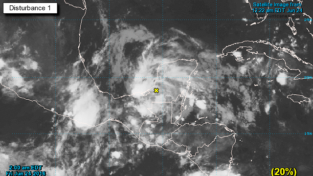
TROPICS: Tropics remain quiet with the exception of a cloudy area over the western Caribbean. Any development of this area will be slow to occur as it moves on a motion to the west-northwest.

THE ALABAMA WEEKEND: A big heat ridge moves over the eastern half of the country on Saturday, so I expect to see highs in the middle and upper 90s. Heat indices will be flirting with the 105 value, so a heat advisory may be required. Just be aware of the heat, slow down your outdoor activities and be sure to stay hydrated by drinking water.
The heat continues into Sunday, with highs in the middle and upper 90s. Again, a heat advisory may be necessary.

NEXT WEEK: Changes begin to occur on Monday as a strong closed low moves eastward into Southeast Canada with a cold front trailing southwestward into Tennessee and Arkansas. This helps to beat that big heat ridge back to the west. That, together with more clouds and the potential for scattered to numerous showers and thunderstorms, will help to keep the heat in check with highs mainly in the lower and middle 90s. Not much of a reduction, but it should be enough to get us away from the need for heat advisories.
Our better chances for rain will come Monday and into Tuesday with the cold front in our area. The GFS has trended a bit slower with the front, so Tuesday will probably be the best day for many people to get wet.
The overall upper air pattern from Wednesday through Friday will be a trough over the eastern U.S. with the ridge once again established over the Southwest U.S. in the vicinity of the Four Corners area. This pattern should offer us some additional heat relief with highs in the 90 to 93 range for the end of next week. This pattern also favors slightly lower humidity, with dew points falling back into the middle 60s. Again, not a big change, but just enough to keep it from feeling so oppressively hot.

The trough, though, establishes a northwesterly flow aloft, so the Southeast U.S. will need to be vigilant for the potential development of these MCSs over the Central U.S. that can travel hundreds of miles and bring stormy weather to the Southeast. There is no skill this far out in determining exactly when and where these may occur, so we’ll just have to be watchful and be prepared to adjust forecasts as we see them develop.
James Spann is on vacation. For more weather news and information from Brian Peters and the rest of the James Spann team, visit AlabamaWX.


