James Spann: Alabama has eyes on the Gulf this week
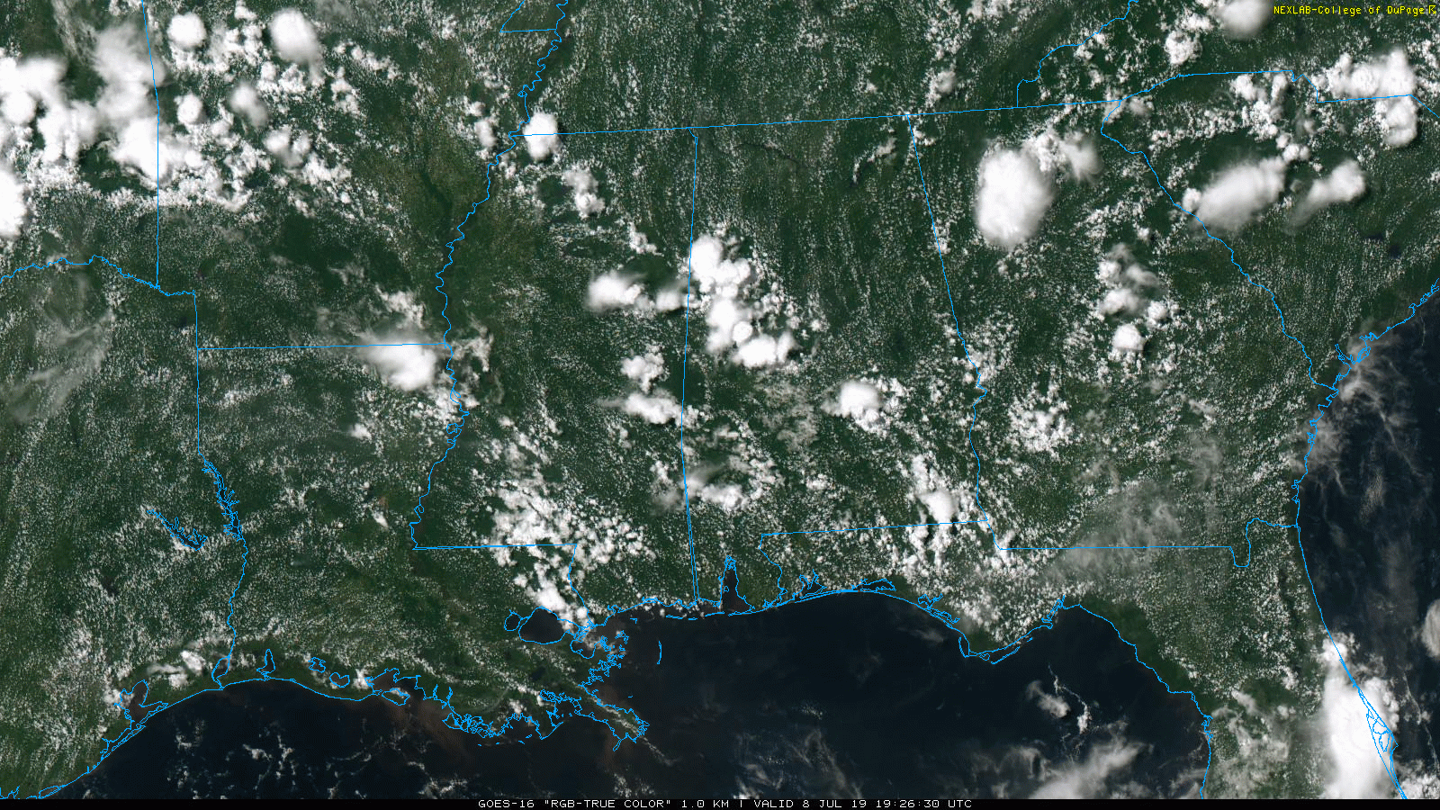
RADAR CHECK: Slow-moving thunderstorms are dumping heavy rain on parts of west and south Alabama this afternoon, but most of north and east Alabama is dry. The storms in progress are moving slowly to the southwest and will fade later tonight. Away from the showers, temperatures are mostly in the low to mid 90s, and humidity levels are pretty oppressive.
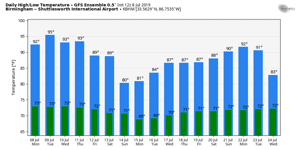
TUESDAY: A decent part of Alabama will be hot and dry Tuesday with only isolated showers and thunderstorms; temperatures will rise into the mid 90s.
REST OF THE WEEK AND THE WEEKEND: Our weather Wednesday through Friday will all depend on a developing tropical low in the northern Gulf of Mexico. Here is the latest.
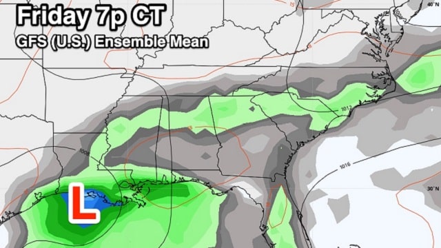
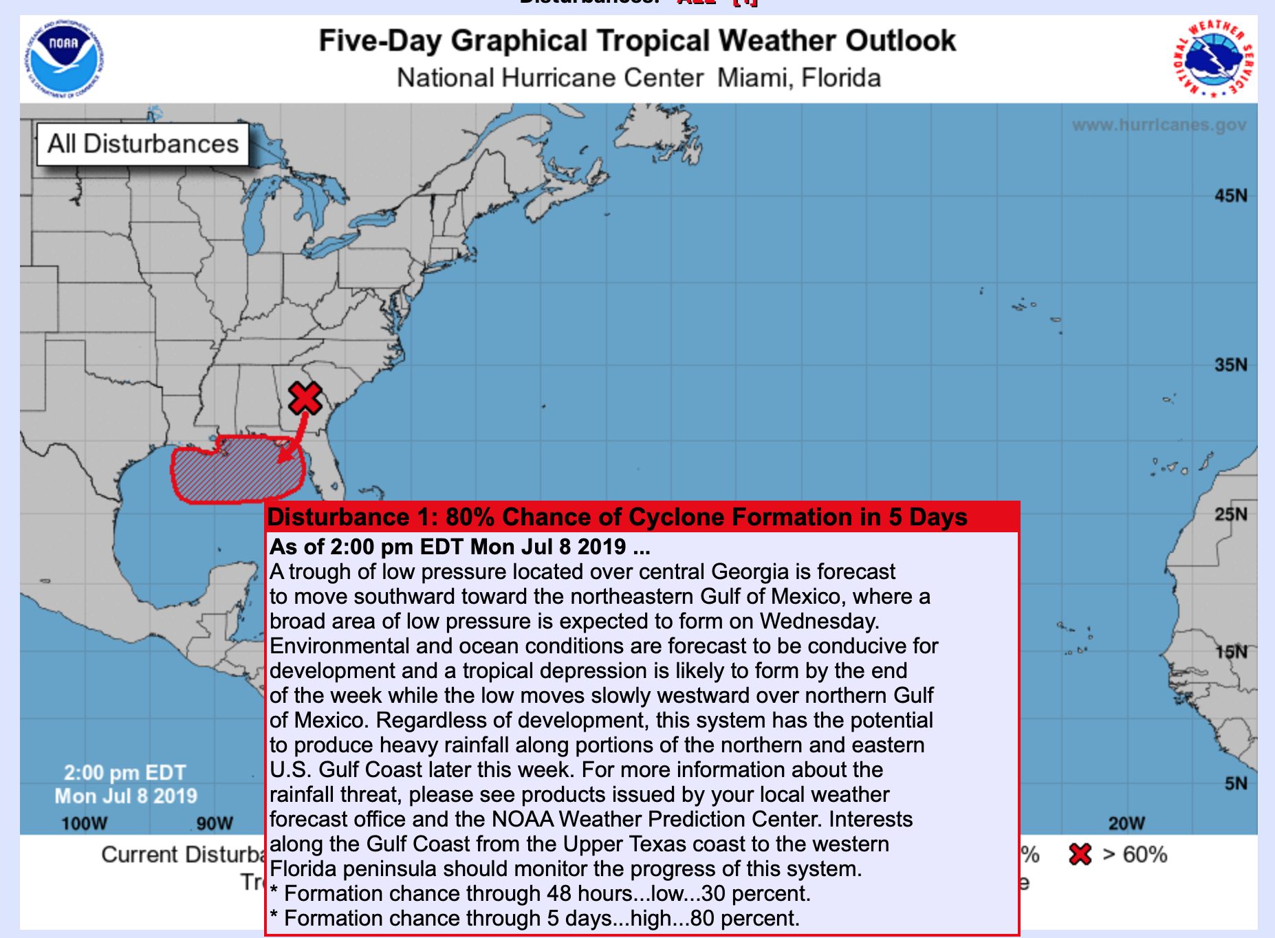
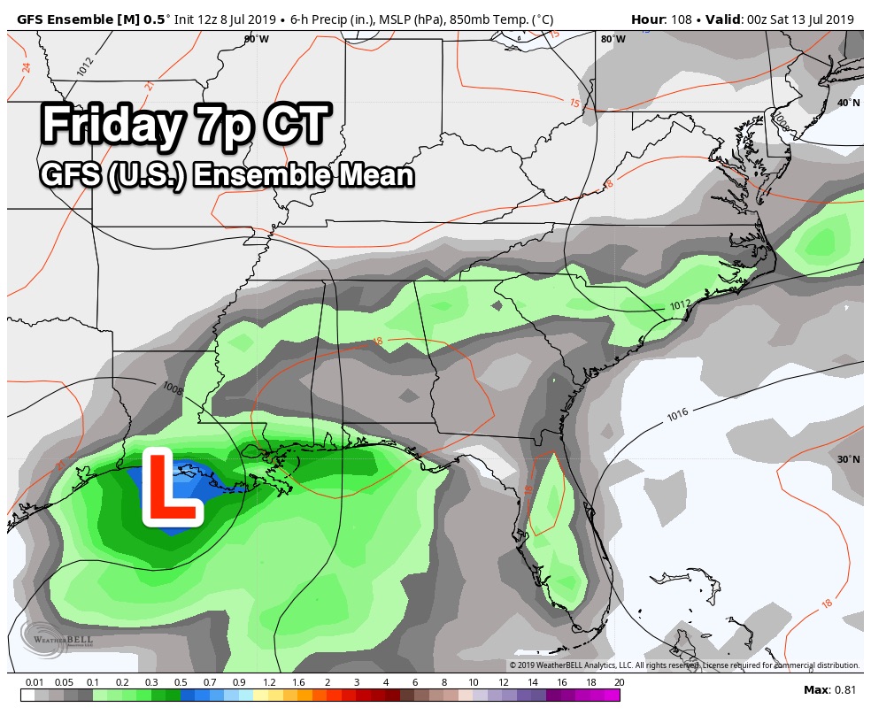
On its new afternoon update, the National Hurricane Center shows an 80% chance of a tropical depression forming over the northern Gulf of Mexico by Wednesday or Thursday. This will most likely drift westward, and new runs of the American (GFS) and European (ECMWF) global models show the system southwest of Morgan City, Louisiana, by Friday evening, then moving into the upper Texas coast over the weekend.
Here are some important notes:
- It is pretty much impossible to forecast the track and intensity of a tropical cyclone until it actually forms a central area of low pressure. The vorticity center that is helping to spin up the system is still over land.
- Odds are high that this will not become a hurricane, but it can’t be totally ruled out. If this becomes a tropical storm, the name will be Barry.
- The main impact, most likely, will be heavy rain, rough surf/rip tides and gusty winds. An isolated tornado/waterspout or two certainly can’t be ruled out.
- The heaviest rain will be along and east of the circulation center, on the onshore flow side. It remains to be seen whether or when the system will begin to move northward. It could continue to drift westward into Texas or turn northward into Louisiana. Accordingly, it is very challenging drawing quantitative precipitation forecast maps right now.
- Rain will likely increase along the central Gulf Coast Wednesday, with periods of rain and a few thunderstorms likely through the weekend. But there will be breaks in the rain, and the sun will peek through at times. It is still too early to define the impact for any given point on the coast. We can do that once we have an established center in the Gulf.
- Most likely, this system will be well inland in six to seven days and weather improves along the coast.
- For now it does look like Alabama will be on the wet, east side of the circulation, meaning deep tropical moisture will be pushed into the state, and we stand a chance of seeing beneficial rain Wednesday through the weekend. But again, there is uncertainty involved with the tropical system right now, and the forecast could change.
Afternoon temperatures will trend downward late this week and over the weekend because of clouds and showers; there’s a good chance we won’t get out of the 80s Friday and over the weekend.
NEXT WEEK: We will slowly trend back toward a more typical summer pattern next week, with partly sunny days and scattered, mostly afternoon and evening showers and thunderstorms. Highs will be in the 87- to 90-degree range Monday and Tuesday, and then back in the low 90s.
ON THIS DATE IN 2003: What may be the world’s highest dew point temperature was recorded at Dhahran, Saudi Arabia, in the Persian Gulf. A dew point of 95 degrees was recorded at 3 p.m. while the air temperature was 108 degrees. The apparent temperature at that time would have been 172 degrees.
BEACH FORECAST: Click here to see the AlabamaWx Beach Forecast Center page.
WEATHER BRAINS: You can listen to our weekly 90-minute show any time on your favorite podcast app. This is the show all about weather featuring many familiar voices, including the meteorologists at ABC 33/40.
CONNECT: You can find me on the major social networks:
Facebook
Twitter
Instagram
Pinterest
Snapchat: spannwx
For more weather news and information from James Spann and his team, visit AlabamaWx.


