Scott Martin: Alabama stays dry with a few more clouds today
- Alexander City — 68 degrees
- Anniston — 68
- Auburn — 69
- Birmingham — 70
- Calera — 69
- Gadsden — 67
- Haleyville — 67
- Marion — 70
- Montgomery — 74
- Pell City — 70
- Selma — 70
- Sylacauga — 70
- Troy — 72
DRY THROUGH THE WORK WEEK: A ridge of high pressure will keep us dry and in above-average temperatures throughout today. We’ll have some mid- to high-level clouds that may filter out the sun a little, but highs should still reach the mid-60s to the lower 70s. Just a little more sunshine, and temperatures could end up a degree or two warmer.
Ridging will be breaking down as moisture will begin to be pulled up from the Gulf of Mexico, but we will continue to stay dry for one more day. Skies will be mostly cloudy Friday with highs reaching the mid to upper 60s.
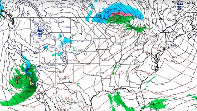
RAIN CHANCES RAMP UP: A surface low will start off the day Saturday over southwestern Kansas and will move northeast through the day. A cold front will trail down into the Southeast from the low, bringing rain chances into the forecast for late Saturday. The atmosphere will be capable of producing thunderstorms late in the evening through the overnight hours, so there may be a few scattered storms out ahead of the front. Highs will be in the upper 60s to the lower 70s.
The low will continue pushing northeast, starting Sunday morning in southern Minnesota and sliding into central Wisconsin by midnight. The main line of rain and thunderstorms will push into northwestern Alabama as early as Sunday morning and progress across the state throughout the day. A strong storm or two may be possible, but at this point the overall threat for severe storms looks marginal. Surface-based instability will be small, but it doesn’t take much with the higher amounts of shear that usually occur with these winter-type systems. Rain should be out of the state by midnight. Highs will be in the lower 60s to the lower 70s.
COOLER TO START NEXT WEEK: A cooler, dry air mass will dominate the Alabama weather to end 2019 and start 2020. We’ll have plenty of sunshine with very few clouds on Monday and New Year’s Eve, with more clouds pushing into the state on New Year’s Day. Highs will be in the 50s all three days.

VOODOO LAND: Highs through Friday, Jan. 10, will stay mostly in the 50s and 60s, but we could see a raw, blustery day on Monday, Jan. 6, as the high looks to be around 40 degrees. Lows throughout the period will mostly be in the 30s to the 50s, with a couple of 20s around Jan. 6-7. This can and probably will change, as this is out in Voodoo Land.
ON THIS DAY IN 1987: Freezing rain plagued parts of the south-central U.S., from northwest Texas to southwestern Missouri. Southwestern Missouri was turned into a huge skating rink as roads became sheets of ice. Damage to tree limbs and power lines compared to a hundred tornadoes, and half the city of Springfield was left without electricity for 24 hours. Snow, sleet and ice covered the northwest two-thirds of Oklahoma. In all, 75,000 homes were left without electricity as ice accumulated 1 to 2 inches in a 40-mile band from Duncan to Norman to Tulsa to Miami, and 25,000 of those homes were still without power a week later. The storm claimed the lives of seven people.
BEACH FORECAST: Get the latest weather and rip current forecasts for the beaches from Bay St. Louis, Mississippi, to Panama City Beach, Florida, on our Beach Forecast Center page. There, you can select the forecast of the region you are interested in.
CONNECT: You can find us on the major social media networks:
Facebook
Twitter
Instagram
For more weather information from James Spann, Scott Martin and other members of the James Spann team, visit AlabamaWx.