Scott Martin: Brief showers possible Saturday in Alabama
Temperatures at 2 p.m. were in the 40s for the most part. Montgomery was the only spot in the 50s at 50 degrees. Gadsden was the cold spot at 40 degrees. Birmingham nearly split the difference at 44 degrees.
Radar is free from any precipitation. We’ll continue to have mostly clear to sunny skies until sunset, with temperatures falling into the upper 30s to the mid-40s around 6 p.m. We’ll have some clouds move across the area tonight through overnight, but we’ll remain dry. Lows will be in the lower 30s to 40 degrees or just over.
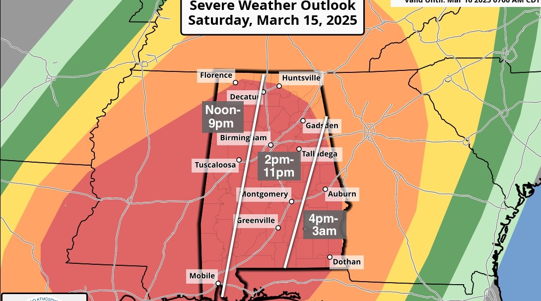
THE ALABAMA WEEKEND: On Saturday, a small, quick-moving disturbance may bring a few light showers, but the lower levels of the atmosphere will be dry, so most of that may evaporate before making it to the surface. Skies will be partly to mostly cloudy and highs will be in the lower 50s to the lower 60s. The chance of rain will be less than 20%.
Much of the day Sunday will be partly to mostly sunny, but clouds look to move in late. Rain chances will start to rise after midnight as the next cold front approaches, setting up a period of unsettled weather for the work week. Highs will be in the lower 60s to just below 70 degrees.

NEXT WEEK: Unfortunately, the rainfall amounts have trended upward for next week. The Weather Prediction Center is forecasting 4 to 7 inches of rain from now until midday next Friday. That is a 1-inch increase from this morning’s forecast. I guess it’s time to see if Noah is ready with the ark.
On Monday, a cold front will move into Alabama. Ahead of the front, the flow of moist air from the Gulf of Mexico will increase, which will set the stage for rain and a few thunderstorms, especially for the afternoon and evening. Rain could be heavy at times. Highs will be in the lower 60s to the lower 70s.
The front stalls out across Alabama Tuesday, which will keep rain and a few thunderstorms likely throughout the daylight hours. Rain chances will decrease a little during the evening, potentially letting some locations have a few hours of no rain. Highs will be in the upper 50s to the lower 70s from northwest to southeast.
The front will finally start moving Wednesday, but we’ll have another day with rain and a few thunderstorms likely at times. It may take a while for the heavier rain and thunderstorms to move in from the west as another impulse approaches. Highs will be in the upper 50s to the mid-60s.
The Global Forecast System has agreed with the European model that rain and thunderstorms will continue through Thursday, with some of those thunderstorms dropping heavy rain. Highs will be in the upper 50s to the upper 60s.
VOODOO LAND: It looks like we will be dry for Valentine’s Day and the following weekend. Temperatures look to be in the upper 50s for highs and lower to mid-40s for lows. Enjoy it while you can, as another system looks to move in by early Monday.
For more weather news and information from James Spann, Scott Martin and other members of the James Spann team, visit AlabamaWx.