Scott Martin: Showers with dropping temperatures for Alabama; sunny, very cool on Sunday

THE ALABAMA WEEKEND: We’ll start off the morning with showers moving eastward through Alabama, with the activity mainly out of the state by mid-afternoon. Skies will remain mostly cloudy. Today’s highs occurred around 12:01 a.m. for locations north of I-59, but everyone will experience dropping temperatures throughout the day. Highs will be in the upper 40s to the mid 70s from northwest to southeast.
Sunday will start off chilly, with early morning lows in the mid 20s to the mid 30s across the state; frost is likely. Even with plenty of sunshine, afternoon highs will make it only into the mid 40s to the mid 50s.
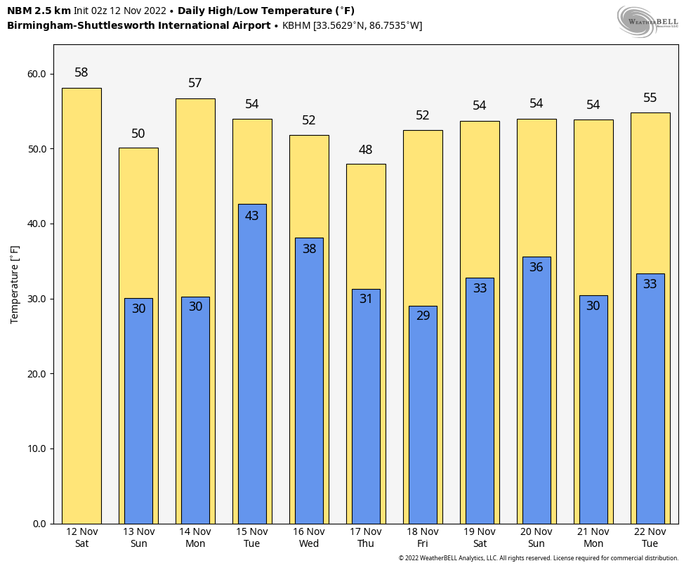
THE WORK WEEK AHEAD: Much of the day Monday will be mostly sunny, but clouds will begin to increase late ahead of our next disturbance. A few showers may be possible by the late evening and into the late night. Highs will be in the lower 50s to the lower 60s.
That disturbance will bring a reinforcing shot of cooler air behind the showers that we’ll see throughout the day Tuesday. Expect a stiff breeze at times that will drop wind chill factors a few degrees below actual temperatures. Highs will be in the lower 50s to the mid 60s.
Clouds will slowly decrease Wednesday, but afternoon highs will be well below normal, in the upper 40s to the upper 50s.
Clouds will be moving back on Thursday as another disturbance hits the state. We can expect a good coverage of showers during the entire day into overnight. Highs will be in the mid 40s to the mid 50s.
On Friday, we’ll continue to have plenty of showers through the morning and into the early afternoon before the activity starts to end from west to east. For now, the evening looks dry for the high school playoff games. Highs will be in the upper 40s to the mid 50s.
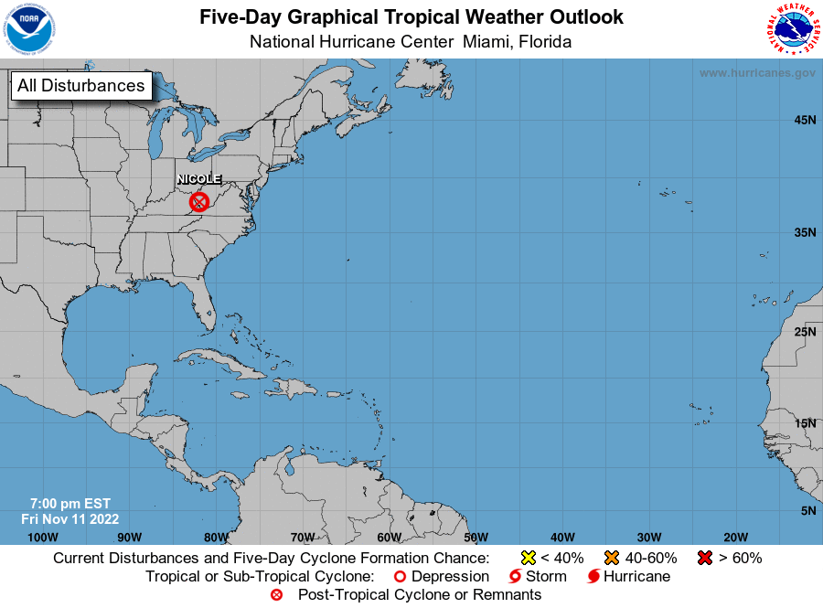
TROPICS: The remnants of Nicole continued to move northeastward and were in West Virginia at 8 p.m. Friday night. While winds may be quite breezy at times over the northeast throughout the weekend, the risk of excessive rainfall and localized flooding will continue to diminish. The rest of the tropics are quiet. The Atlantic Hurricane Season ends Nov. 30.
ON THIS DATE IN 1988: Thunderstorms developing ahead of a cold front produced severe weather in the lower Mississippi Valley during the afternoon and early evening. Thunderstorms produced wind gusts to 80 mph at Bovina, Mississippi. Morning thunderstorms drenched Atlanta, Texas, with more than 4 inches of rain.
For more weather news and information from James Spann, Scott Martin and other members of the James Spann team, visit AlabamaWx.


