James Spann: New day, old forecast for Alabama
James Spann says more heat warnings, advisories in effect for Alabama from Alabama News Center on Vimeo.
THE HEAT IS ON: The hottest week of the year rolls along for Alabama and the Deep South. A strong upper ridge will mean mostly sunny, hot days and fair nights through the weekend with highs between 96 and 100 degrees for the northern half of the state. Communities across southwest Alabama will top out in the 100- to 105-degree range. Heat indices will be well over 100; all 67 counties are in either a heat advisory or an excessive heat warning.
Sinking air associated with the upper high means no rain through Saturday; we will introduce a small risk of a shower or storm Sunday afternoon as the heat ridge begins to weaken.
NEXT WEEK: We get a break in the heat as the ridge continues to weaken and shift westward. Monday’s high will be in the low 90s, followed by mid to upper 80s through the rest of the week. A shower or storm is possible Monday, but some rain is more likely Tuesday as a surface front drifts into the state. Models are hinting that drier air could creep into the northern half of Alabama over the latter half of the week, with lower humidity and cooler nights.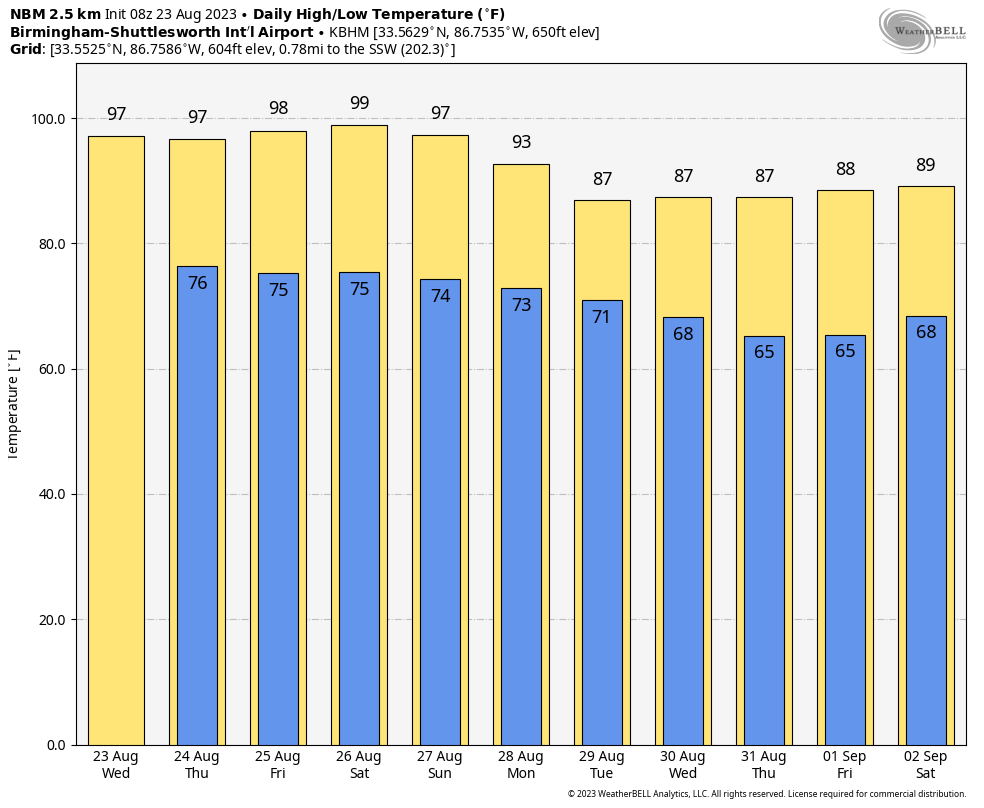 FOOTBALL WEATHER: For the first week of high school football, it will be very warm and humid across Alabama Friday night. The sky will be clear with temperatures falling through the 80s during the game.
Saturday, Jacksonville State hosts the University of Texas at El Paso (4:30 p.m. kickoff) at Burgess-Snow Field; the sky will be mostly clear, and the day will be very hot. Expect a kickoff temperature near 97 degrees, falling into the upper 80s by the final whistle.
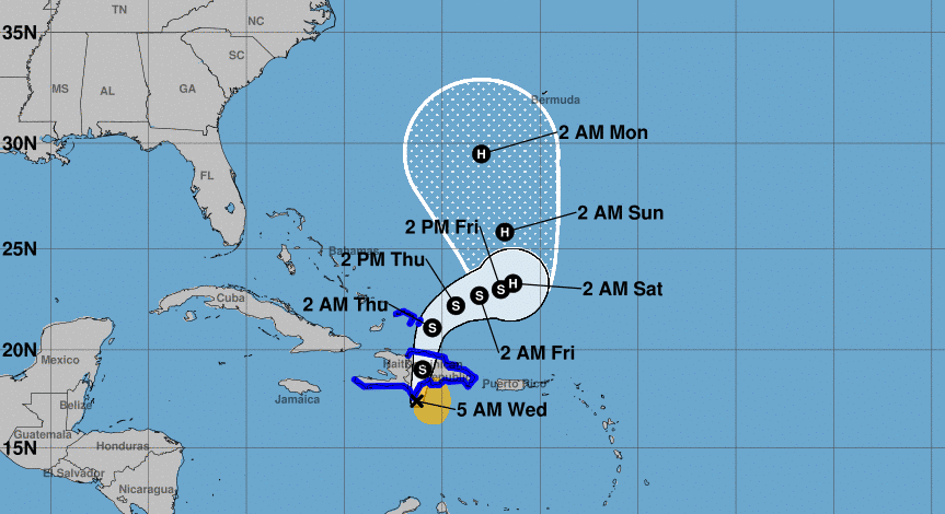
TROPICS: Former Tropical Storm Harold will dissipate this morning over west Texas. Tropical Storm Franklin is centered about 100 miles southwest of Santo Domingo, Dominican Republic, with winds of 50 mph. It will bring heavy rain and flooding potential to Hispaniola through tonight as the system moves slowly northward.
Franklin is forecast to reach hurricane strength this weekend between the Bahamas and Bermuda. From there it will move north/northeast and remain well east of the U.S.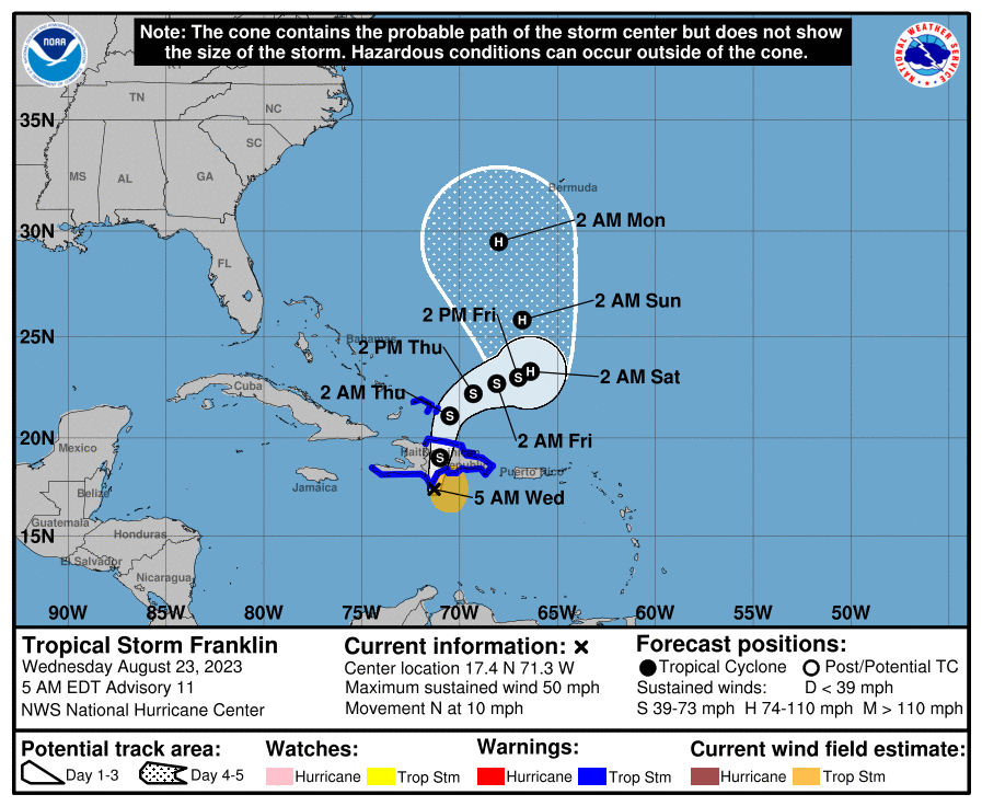 In the Central Atlantic, the remnants of former Tropical Storm Emily could regenerate into a depression or storm over the next few days, but it is moving northward and will remain far from land.
Another disturbance in the eastern Atlantic (Invest 92L) could blossom into a tropical depression by the weekend. This will likely gain latitude and will remain far from land as well.
No tropical systems are expected near the U.S. for at least the next seven days.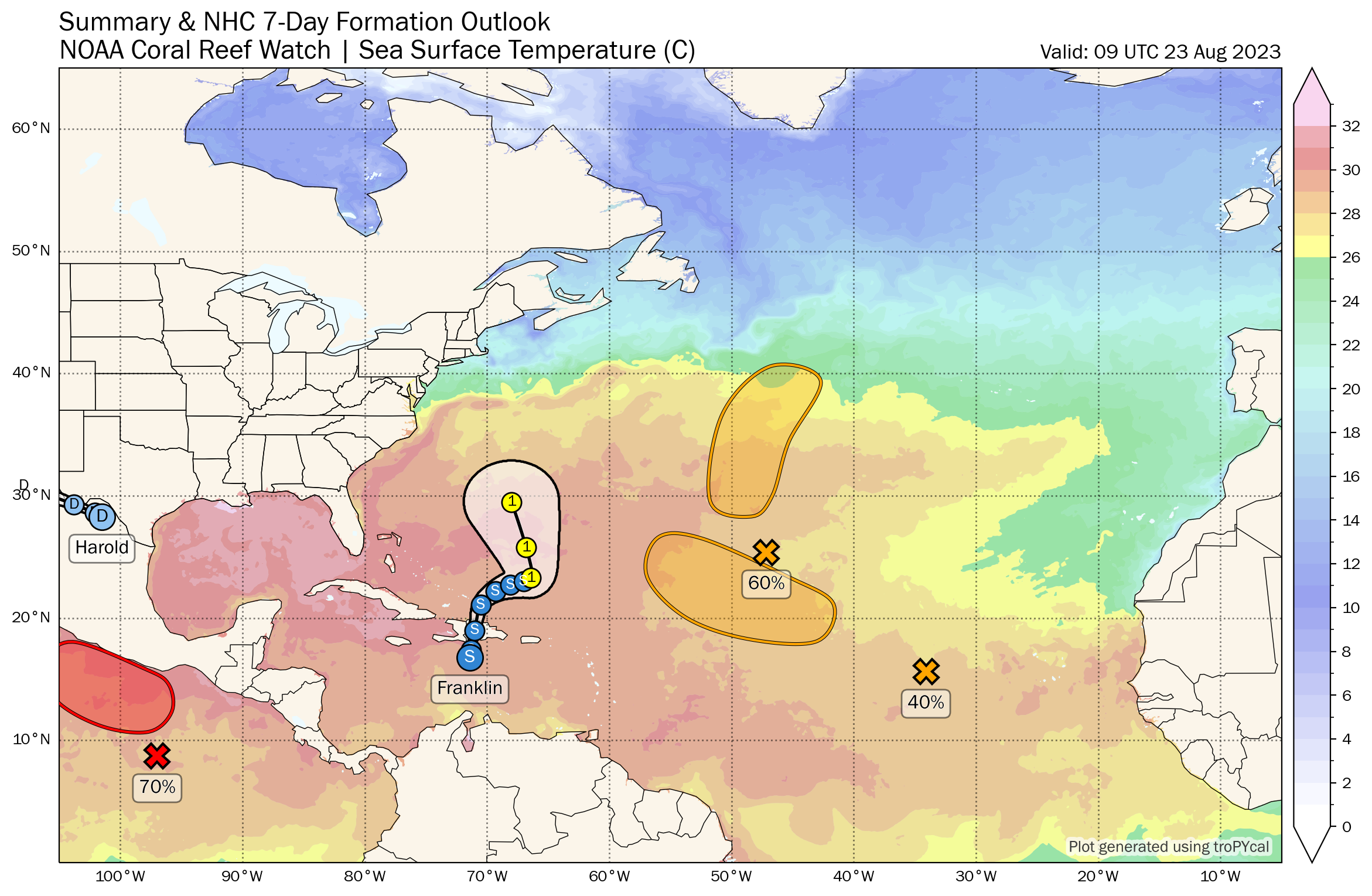 ON THIS DATE IN 1933: A hurricane made landfall near Nags Head, North Carolina, and tracked up the Chesapeake Bay. The Chesapeake-Potomac hurricane moved over Norfolk, Virginia, and Washington, D.C. A 7-foot tide flooded businesses in Norfolk. The hurricane was described in the American Meteorological Society’s August 1933 weather review as “one of the most severe storms that have ever visited the Middle Atlantic Coast.”
ON THIS DATE IN 1992: While south Florida residents were preparing for Hurricane Andrew, folks in western Montana were dealing with early-season snowfall. Amounts included 8.3 inches in Great Falls, 6.2 inches in Helena and 5.1 inches in Cut Bank. This was the first significant snowfall on record in western Montana in August.
For more weather news and information from James Spann and his team, visit AlabamaWx.


