James Spann: Cool, dry Saturday for Alabama; rain possible Sunday

James Spann forecasts more below-average temperatures, dry Saturday for Alabama from Alabama News Center on Vimeo.
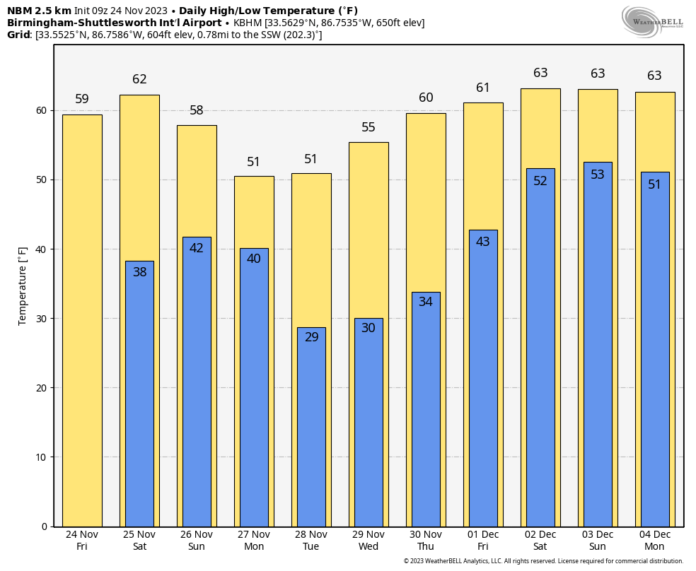
RADAR CHECK: We have a few sprinkles over the northern half of Alabama just before sunrise. Those will end soon, and the rest of the day will be dry. Clouds this morning will give way to gradual afternoon clearing with a high between 57 and 64 degrees across the state. Tonight will be mostly fair with lows in the 30s over the northern counties and 40s to the south.
THE ALABAMA WEEKEND: We are forecasting a partly to mostly sunny sky Saturday with a high between 58 and 65 degrees. On Sunday, the sky becomes mostly cloudy ahead of a weather disturbance that will bring a chance of some rain to the state. With limited moisture, rain amounts should be one-quarter inch or less for most places Sunday afternoon and Sunday night, certainly not a major rain event. Heavier totals will be over the southern quarter of the state.
NEXT WEEK: A new surge of colder air arrives Monday, and temperatures will be below freezing over the northern half of the state Tuesday and Wednesday mornings. Some communities across the Tennessee Valley won’t get out of the 40s Monday and Tuesday. The weather will be dry for much of the week, but we will bring in a chance of rain on Friday, Dec. 1. It’s way too early to know how much rain will fall.
 FOOTBALL WEATHER: For the high school playoff games tonight, the sky will be mostly clear with temperatures falling into the 40s.
For Saturday’s Iron Bowl (Alabama at Auburn, 2:30 p.m. kickoff), it will be sunny and about 63 degrees at kickoff, dropping into the 50s by the second half — a perfect day for the biggest football game of the year in Alabama.
TROPICS: A nontropical area of low pressure over the central subtropical Atlantic is producing disorganized shower and thunderstorm activity, and the associated winds have decreased below gale force. This system could acquire some subtropical or tropical characteristics during the next day or two while it moves northeastward at 15 to 20 mph. The chance for subtropical or tropical development is likely to end by Sunday as the low moves over much colder waters.
The National Hurricane Center gives it a 30% chance of development, and the feature is far from land. Hurricane season ends in six days.
ON THIS DATE IN 2001: Two dozen tornadoes touched down across Alabama; two people were killed at Sand Rock in Cherokee County and two others at Kennedy in Lamar County. The most violent tornado of the day was an F4 that moved through Blount and Etowah counties near Altoona; 22 were injured.
ON THIS DATE IN 2004: A total of 16 tornadoes touched down across Alabama, including F2 twisters at Lake Mitchell and Autaugaville. Another strong tornado touched down at approximately 7:09 a.m. on the property of Talladega Superspeedway, damaging concession stands and the Busch Series garage area, and destroying a digital leaderboard. Debris was strewn all throughout the infield and into Victory Lane before the tornado moved northeastward. This F2 tornado caused the only death in Alabama throughout the event. A few houses and outbuildings were damaged in the Eastaboga area before it moved into Bynum. Two mobile homes were heavily damaged by fallen trees, with one of those trees killing a 75-year-old woman. It continued into the Coldwater area and into the southwestern part of Anniston, damaging more buildings and knocking down numerous trees.
For more weather news and information from James Spann and his team, visit AlabamaWx.


