James Spann: Hot, mostly dry weekend for Alabama
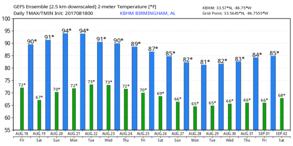
QUIET PATTERN: While we will hang on to the risk of a few isolated showers or storms today, it sure looks like most of north and central Alabama will be rain-free through early next week as drier air will slip into the state during the next 24 hours. The sky will be partly to mostly sunny today with a high at or just over 90 degrees.
Tomorrow and Sunday will feature a good supply of sunshine with hot afternoons; the high both days will be in the low to mid 90s. The chance of a shower or storm is not zero over the weekend, but it is less than 10 percent, and for now we won’t mention it in the forecast.
ECLIPSE MONDAY: Looks like a good day to watch a solar eclipse — partly to mostly sunny with only a scattered field of cumulus clouds during the eclipse Monday from noon to 3 p.m. The chance of a shower for any one spot is small, and the high will be in the low 90s. And, as we have been reminding you for weeks, do NOT look at the sun with the naked eye at any point during the eclipse. The peak will come at 1:31 p.m.
REST OF NEXT WEEK: Moisture returns, and we will bring back the chance of scattered showers and storms, but another dry air mass drops in here Thursday and Friday with generally dry conditions both days. Some of the cooler pockets could see a low around 60 degrees by Friday morning of next week.
TROPICS: As you might expect in mid-August, things are heating up:
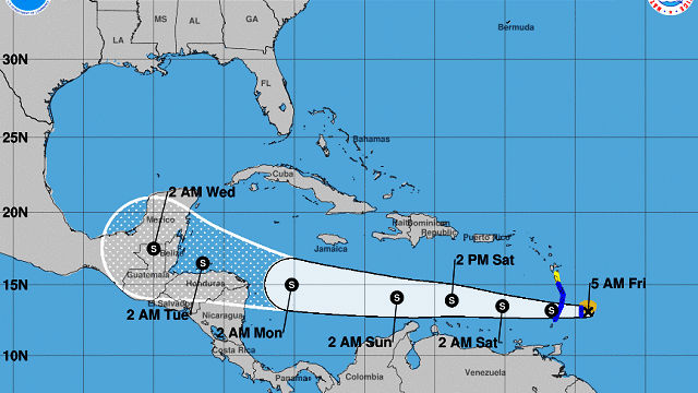
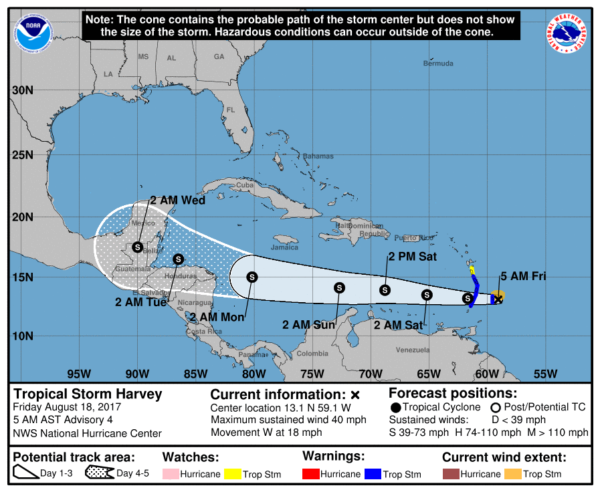
- TROPICAL STORM HARVEY: Harvey is bringing heavy rain to the Windward Islands this morning; it will cut across the Caribbean in coming days, and is expected to move into Belize and the Yucatan Peninsula toward the middle of next week. Environmental conditions are not favorable for strengthening, and the National Hurricane Center keeps the system below hurricane status in its forecast.
- INVEST 92L: This one is expected to become a tropical depression, Tropical Storm Irma, in the next 36 hours. Models bring this to the Bahamas in four to five days, but harsh winds aloft will be a big issue, and both the Global Forecast System and ECMWF models lose this before it reaches South Florida.
- EASTERN ATLANTIC: The easternmost disturbance will gain latitude. If anything develops there, most likely this will recurve and won’t be a threat to land.
ON THIS DATE IN 1969: Late in the evening on Aug. 17 and into the early morning of Aug. 18 in 1969, Hurricane Camille made landfall along the Mississippi Gulf Coast near Waveland. Camille is one of only three Category 5 hurricanes ever to make landfall in the United States, the other two being the 1935 Labor Day Hurricane in the Florida Keys and Hurricane Andrew, which hit the Miami area in 1992. Camille also ranks as the second most intense hurricane (ranked by pressure) to strike the continental U.S., with the two hurricanes listed above ranked 1 and 3, respectively. The actual maximum sustained winds are not known, as the hurricane destroyed all the wind-recording instruments in the landfall area. Re-analysis data showed peak winds of 175 mph along the coast. A devastating storm tide of 24.6 feet occurred west of our area in Pass Christian, Mississippi. In total, Camille killed 259 people and caused $1.42 billion in damages (in 1969 dollars, $9.27 billion in 2017 dollars).
BEACH FORECAST: Click here to see the AlabamaWx Beach Forecast Center page.
WEATHER BRAINS: You can listen to our weekly 90-minute netcast anytime on the web, or on iTunes. This is the show all about weather featuring many familiar voices, including meteorologists at ABC 33/40.
CONNECT: You can find me on all of the major social networks:
Facebook
Twitter
Google Plus
Instagram
Pinterest
Snapchat: spannwx
For more weather news and information, visit AlabamaWx.